Southern Manitoba has its first major snowstorm of Winter 2015/16 on the doorstep as a Colorado Low moves northeastwards through the American Plains and is poised to produce 10–20 cm of fresh snow through the Red River Valley.
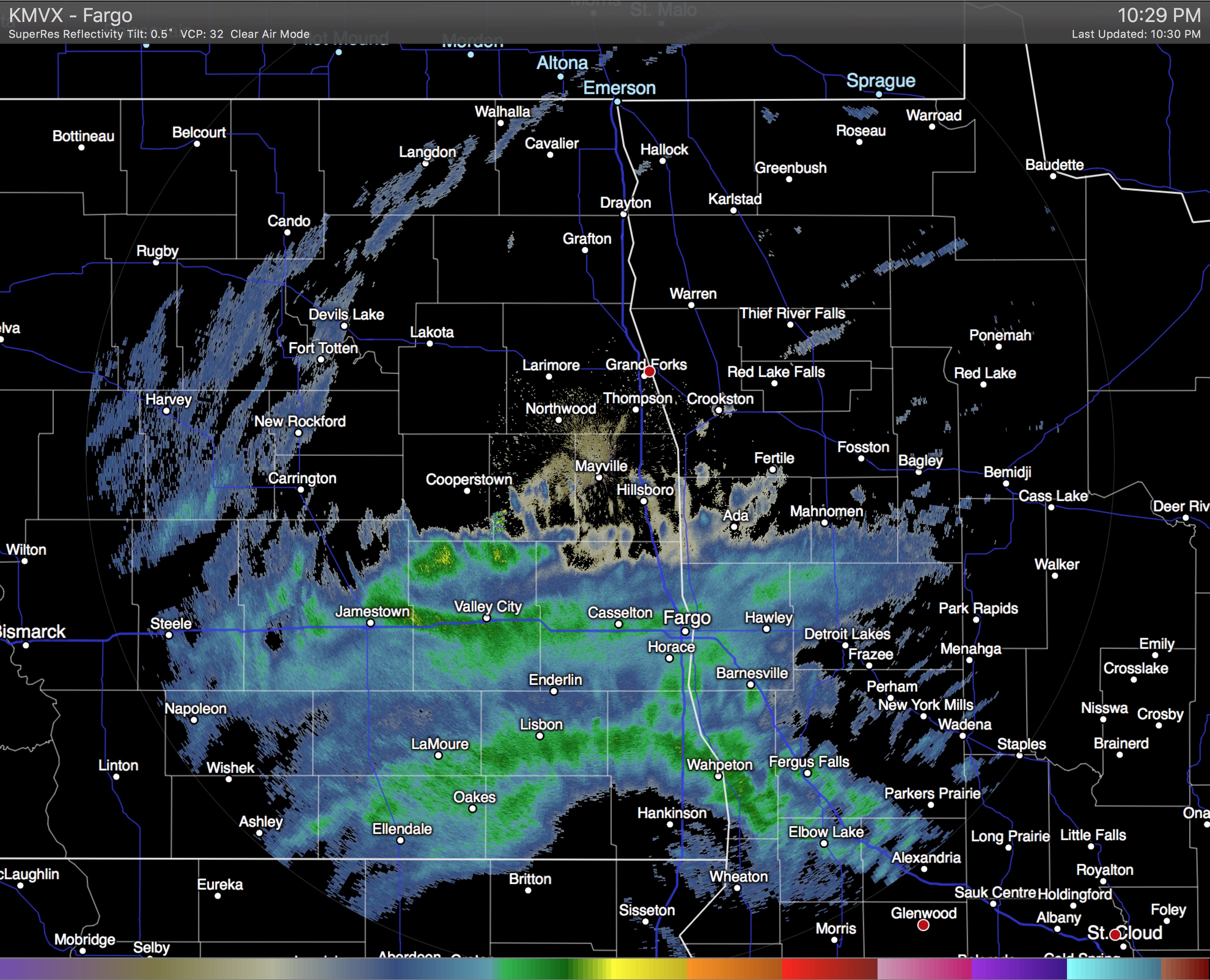
The incoming Colorado Low has spread snow across South Dakota this evening which is now pushing into North Dakota and Minnesota. This area of snow will intensify as it heads northwards courtesy a steadily organizing weather feature called an inverted trough. This trough of low pressure extends north/northwest out from the centre of the Colorado Low and will draw moisture into the Red River Valley and produce a swath of heavier snow through the region.
At this point, it looks like the snow will begin pushing across the U.S. border sometime between 2 and 4 A.M. and then spread into Winnipeg before 4 and 6 A.M.. The heavier snow will build into the Red River Valley between 6 and 9 A.M. and persist until near lunch time. Through the first half of the day, as much as 10 cm could fall; that’s a fairly intense snowfall rate and will undoubtedly have significant impacts on transportation. The snow will ease slightly for the afternoon, but still be fairly persistent, dropping another 2–5cm or so.
Heading into the evening and overnight hours, the snow will begin to become a little bit more disorganized save for one area known as the deformation zone. This feature will be the western-most extent of the snowfall and will typically have slightly more organized precipitation along it. Best indications at this point are that the deformation zone will line up through the Interlake and Red River Valley, meaning it’s fairly likely that more persistent light snow will last through the night. This snow could produce anywhere from 1–3cm more.
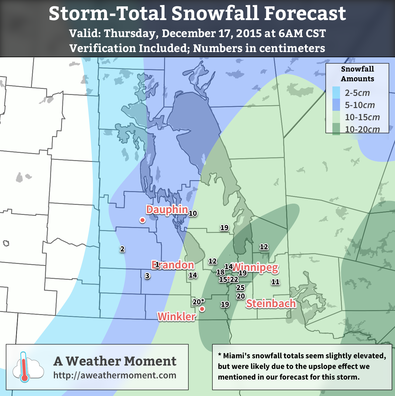
By Thursday morning, the snow should be tapering off to flurries and moving out of the region. When all is said and done, it’s likely that anywhere from 10 to 20cm of fresh snow will have fallen in the Red River Valley. Localized amounts could possibly exceed 20cm in a few particular locations, namely anywhere that may see upslope enhancement in the northerly winds: the western escarpment of the Red River Valley and north side of Turtle Mountain being to of the most likely places. These higher amounts would be very localized, though, and are not reflected in the above snowfall forecast, which is looking more at large-scale snowfall totals.
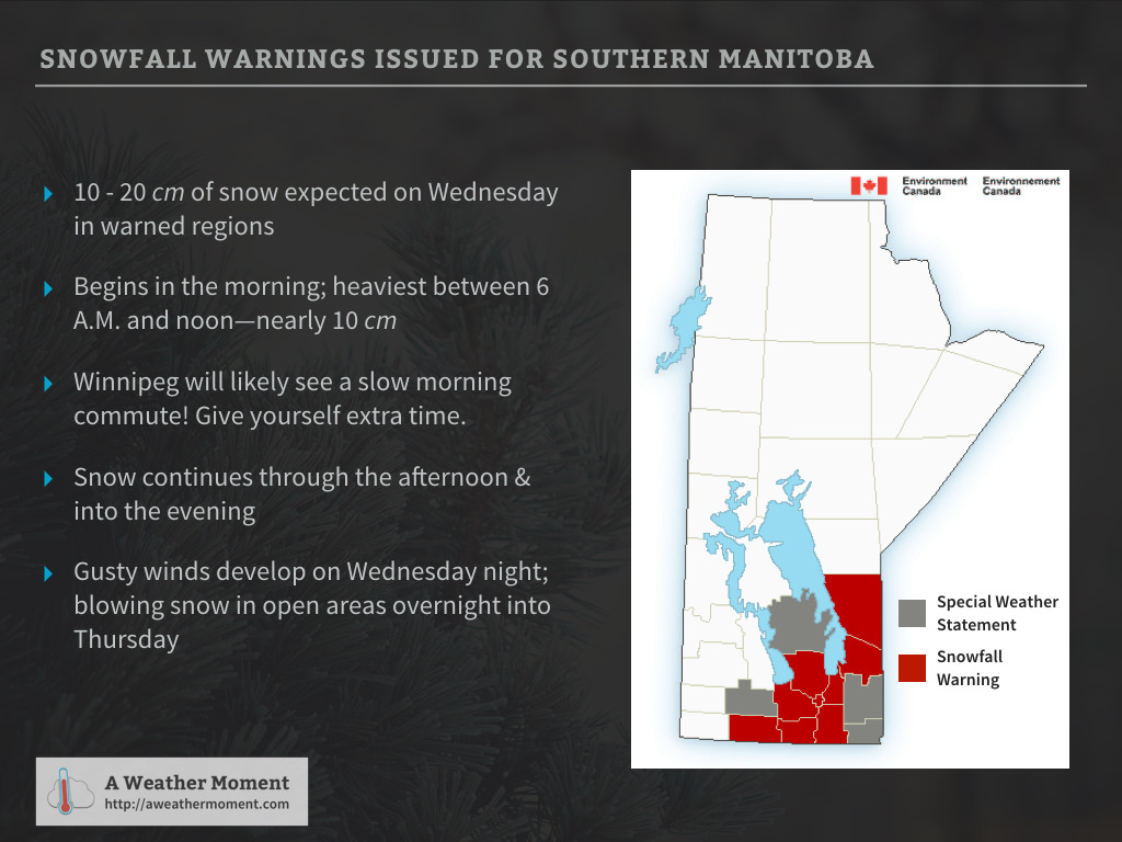
Environment Canada has issued a snowfall warning arcing across the Red River Valley with the discussion showing very similar thinking: 10–20cm of snow, heavy first thing Wednesday morning, then blowing snow and cooler temperatures heading into Thursday.
Cooler with Blowing Snow Behind the Colorado Low
Beginning Wednesday evening, northwesterly winds will begin moving into southern Manitoba. Despite the cooler temperatures pushing in and the relatively strong winds aloft, winds will likely only reach around 30 gusting to 50 km/h overnight.[1]
By Thursday morning, the wind will strengthen to 40 gusting 60 km/h, which when combined with the fresh snow, will almost undoubtedly produce fairly widespread blowing snow through the Red River Valley. These stronger northwesterly winds will also be ushering in a much cooler air mass that will drop temperatures to –20°C by Saturday morning.
This colder weather, while an abrupt change from what we’ve been seeing for the past month and a half, is actually not all that uncommon. Normal daytime highs for Winnipeg this time of year are around –10°C with normal overnight lows near –20°C. So while we’ll see temperatures dropping 10–15°C, they’ll be seasonal to just slightly below seasonal for this time of year.
Fortunately this cold snap will be brief. Early next week it looks like a weak system will move through bringing a chance for some light snow and a return to slightly above-seasonal temperatures.
- This is due to the cyclonic curvature of the surface pressure gradient which can act to diminish wind speeds. ↩
Anyone have accumulation totals yet?
Yes! Sorry I didn’t get back sooner, I was quite busy today. I’ve posted a new comment with a map included with snowfall totals and a verification of how our forecast did!
I’ve attached a verification of our forecast to this post as well as replaced our forecast image above with one that has verification numbers on it.
Overall, I’m quite happy with how the forecast turned out. The snow moved into Southern Manitoba about when expected and, generally, things progressed as we had thought. There are three particular points of interest to note with how things panned out:
1. We had said it would be heaviest in the morning then lighter in the afternoon, but there was a few hours of quite heavy snow in the afternoon. We were both right and wrong on this one. There are two aspects to snow, how much it piles up, and how much water it contains. If you were to melt all the snow that fell in the morning and compare it to al the snow that fell in the afternoon, it would show that the morning snowfall actually contained more water than the afternoon snowfall did.
The amount of water in snow relates to how much it piles up through something called the SLR—snow to liquid ratio—which essentially measures how fluffy it is. The snow in the morning, despite containing more water, wasn’t as fluffy as we expected, while the snow in the afternoon, containing less water, was fluffier than expected. That led to some rapid late-day snowfall accumulations. It’s always a difficult thing to forecast and while I’m overall happy with how the forecast as a whole turned out, I’ll confess the distribution of accumulation wasn’t quite what I was expecting.
2. Overall, the snowfall totals line up very well with what we were expecting. A few places crept over the 20 cm mark, the band of heaviest snow mostly occurred where we were expecting, save for the northern extent of it. Cross-checking with RADAR imagery, I think the band was aligned a little more north-south heading towards the lakes, which would help explain the slightly lower amounts in Pinawa compared to other areas in that heavy band and the higher amounts in Arborg. Amounts dropped off quickly to the west as expected, but we could have tightened up that gradient even more.
3. A few snowfall observations seem like they need a bit of a disclaimer attached to them. The first is Miami, which I’ve noted with an asterisk. The amounts are slightly higher than they seem like they should be when compared to surrounding sites and RADAR, however I believe that they likely had low-level enhancement due to upslope flow near the escarpment. Stony Mountain, just north of Winnipeg, seems low and I’m not entirely sure that report is correct. I included it, but wouldn’t be surprised if they had another inch or two more than was reported. Lastly is Arborg whose higher amounts I believe were a combination of the heaviest band ending up being closer to them than we forecast, combined with some snowfall enhancement from additional low-level moisture being fed into the region in the north/northeasterly winds from the still-open north basin of Lake Winnipeg.
All in all, I’m quite happy with how the event ended and the accuracy of the forecast. From bare grass to winter wonderland in a single day!
For the sake of posterity, here’s EC’s summary of the event. Also, worth noting, is that the forecasters at Environment Canada did a pretty good job with this event, from a Christmas-song infused SWS days in advance to almost 24 hours notice with the snowfall warning, they had it covered!
Weather summary
for Manitoba
issued by Environment Canada
at 10:35 a.m. CST Thursday 17 December 2015.
==Discussion==
The first major snowfall of the season occurred over portions of
southern Manitoba on Wednesday when a Colorado Low moving through
Minnesota spread a narrow band of snow, heavy at times, across the
border and into the region.
Light snow began in many locations between 3 and 6 AM on Wednesday
and then intensified through the morning hours. By midday, between 5
to 8 cm had fallen in many locations. In the afternoon, cooler
temperatures developing in the mid-levels of the atmosphere helped
produce significantly “fluffier” snow than fell in the morning and
rapid snowfall accumulations took place, with some locations seeing
snowfall rates as much as 2.5 cm per hour.
The heaviest snowfall occurred roughly through the central and
eastern Red River Valley and then extending northeastwards through
Winnipeg and onwards towards the south basin of Lake Winnipeg.
Heading west of the Red River Valley, snowfall accumulations
diminished fairly quickly.
The following is a summary of weather event information received by
Environment Canada.
Summary of storm-total snowfall in centimeters (to 9:00 AM CST
December 17, 2015):
Ste. Anne: 25
Winnipeg: 15-22
Steinbach: 20
Miami: 20
Pinawa: 19
Morris: 19
Oakbank: 19
Arborg: 19
Rosser: 18
Portage: 14
Stony Mountain: 14
Woodlands: 12
Great Falls: 12
Rennie: 11
Ashern: 10
Brandon: 3
Shoal Lake: 2
Neepawa: 1
Please note that this summary may contain preliminary or unofficial
information and does not constitute a complete or final report.
End/PASPC