Storm Chase Log – July 9th to 10th

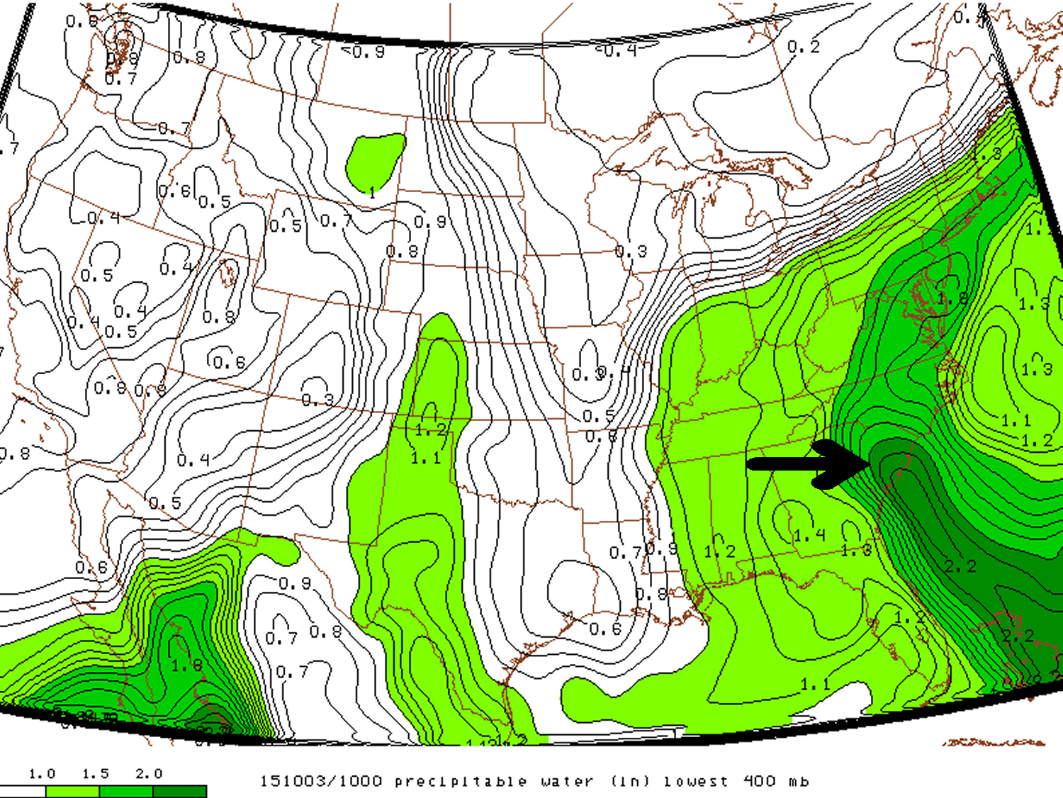
As Brad forecasted on his Friday post, severe storms were expected on Saturday across southwest Manitoba as a result of an upper level ridge that rounded the southern Canadian Prairies began breaking down. Scott and I decided on Friday night to head out from Winnipeg for a chase around noon on Saturday in expectation of the severe storms.

July 9th

We decided, as our general target area, to head south of Brandon and refine the area as the early afternoon wore on because elevated convection was ongoing in the region. As we headed down highway 2, conditions looked promising for surface based storms as there wasn’t much cloud cover near border regions.

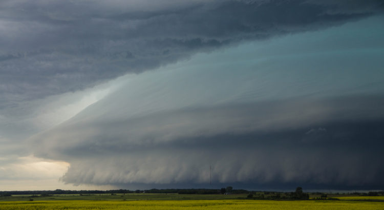
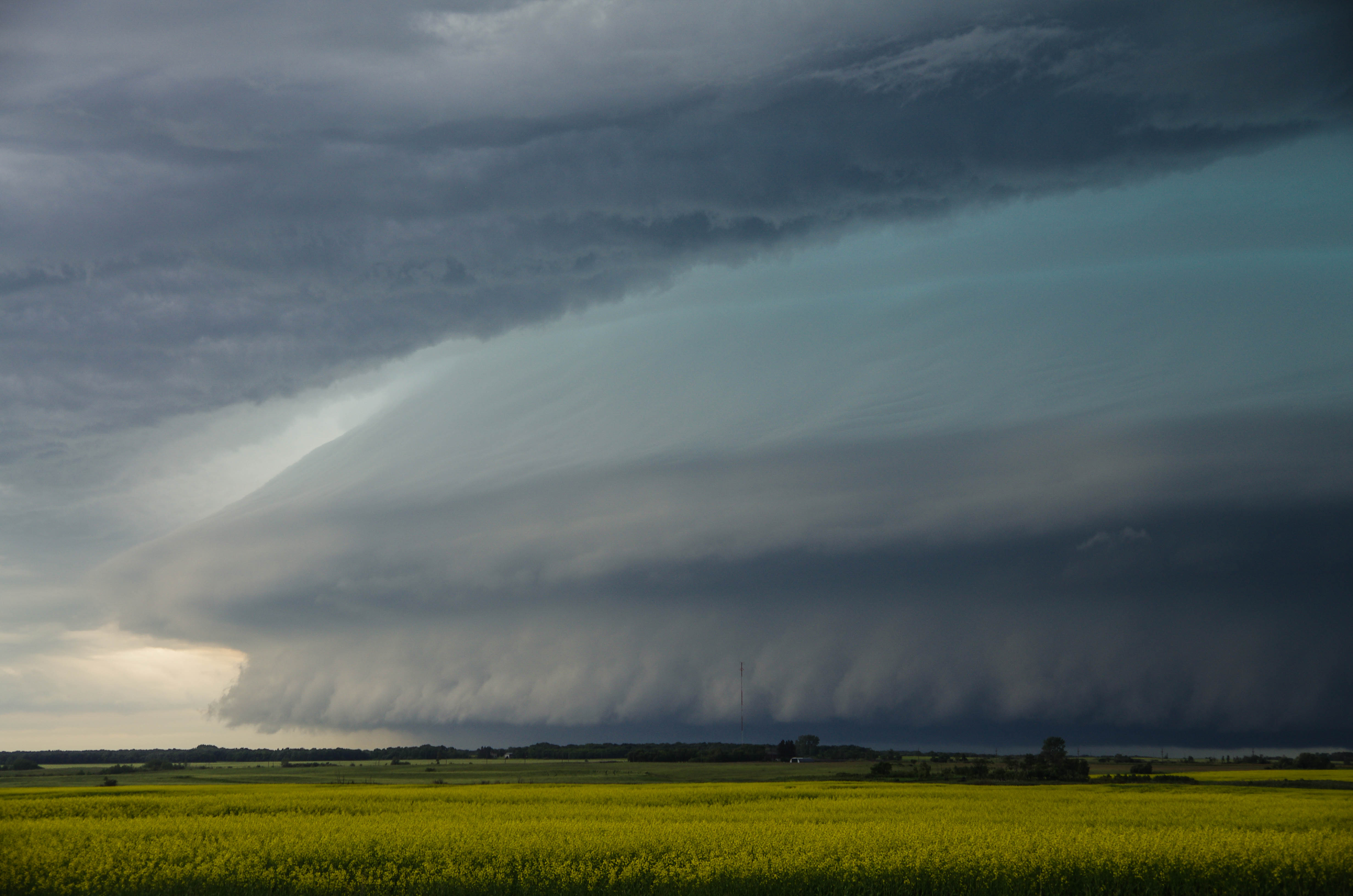
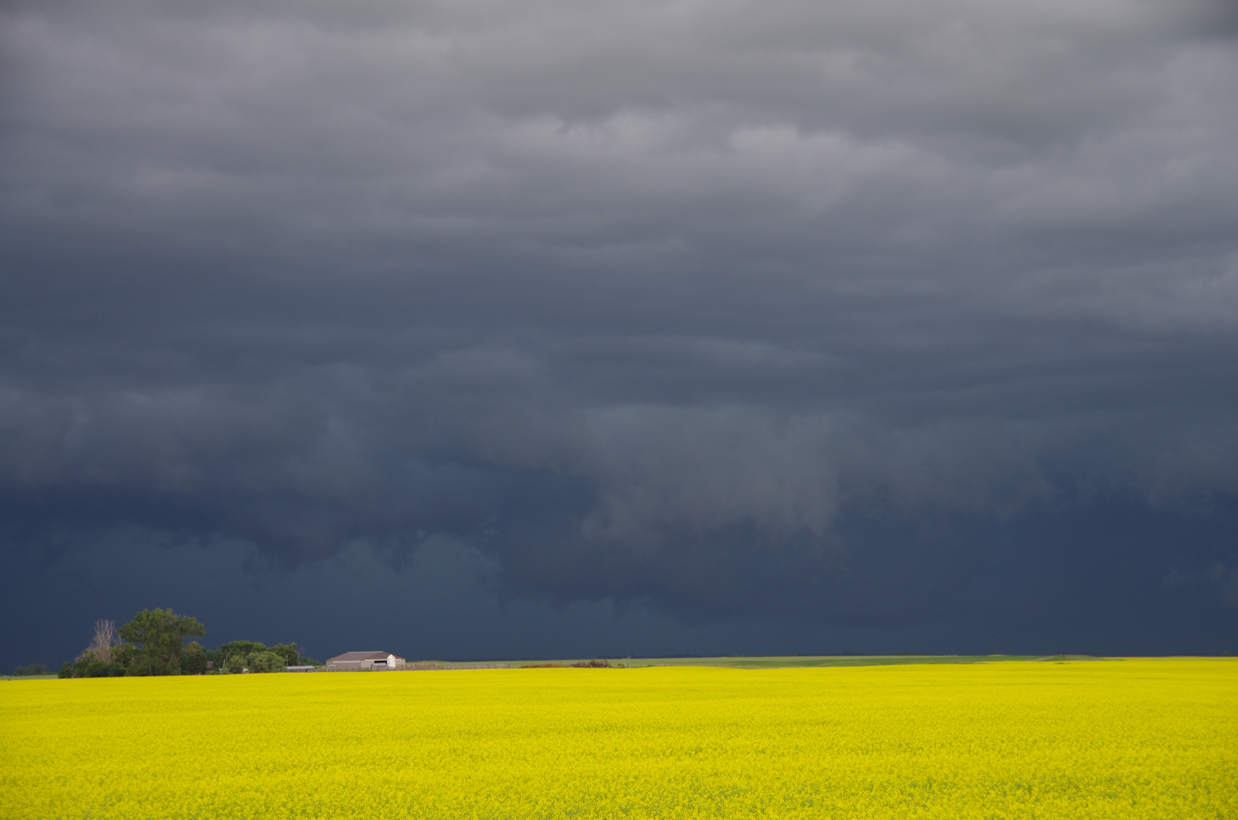
Initially we kept an eye on bubbling cumulus near Melita as we blasted west, however as we approached the so thought “elevated storms” near Souris it was evident that the storm had become surface based. Clear skies and warm temperatures south of the storm allowed the storm to ingest surface parcels as it dived southeastward. As we initially got close to the storm, we saw that the storm had a ground scraping shelf cloud – some of the best storm structure observed in southern Manitoba this year was observed west of Ninette. We continued to follow the storm in a southeasterly fashion and rotating wall clouds formed on a few occasions near Minto and Dunrea. It was also evident that the storm was producing damaging hail as the core had a greenish tinge of color.

Ground-scraping shelf cloud as we initially approached the storm north of Ninette.

Ongoing storms south of the border near Devils Lake spat out rain-cooled air and the supercell storm eventually began dying off near Cartright. Regardless, we continued to follow it south of the border until it eventually gusted out by late afternoon. We then looked at the weather models and saw that the next day could once again produce strong storms, this time in western North Dakota so we headed to Minot for the night.

A few rotating wall clouds were observed as the supercell dove southeasterly, northwest of Killarney.

July 10th

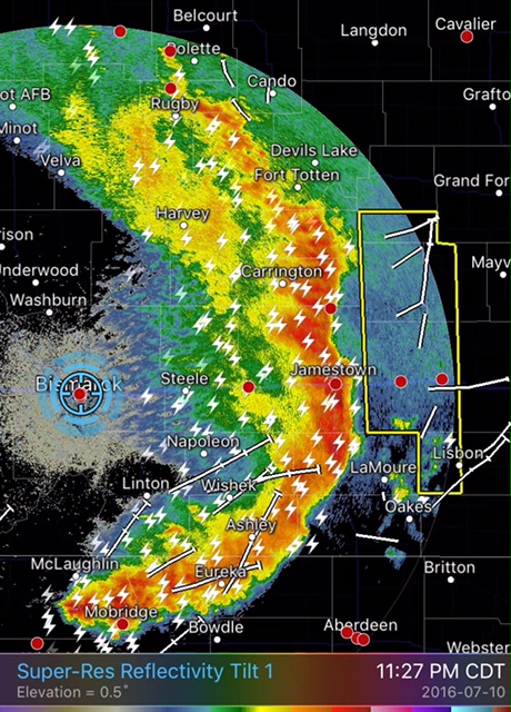
On the morning of the 10th we did our analysis and looked at short term convective models only to find that there was much disagreement as to what would happen during the afternoon. Most models did convect strong storms in the Dickinson area so we headed in that direction, from Minot. Unfortunately we forgot to check for construction delays before leaving and picked a highway that had construction for over 30 km. After a scenic route through the badlands of western North Dakota, we approached our target area. Simultaneously, storms began to form to our southwest near Baker, Montana – great timing!

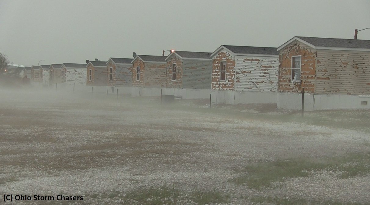
We passed through Killdeer, North Dakota and headed to Dickinson to orient ourselves south of the storm. By then the storm was a full-fledged supercell. Once again it was evident that the storm was chucking very large hail. Green skies were present and the radar depicted reflectivities of over 70 dBz, we had to make sure not to get caught in the core of the storm. We first took a peek at the storm just northwest of Dickinson – this is when the storm looked best. A rotating wall cloud was observed and the storm appeared to be close to producing a tornado. Only about a half-hour or so after the wall cloud was initially observed however, the rear flank downdraft (RFD) of the storm had a mighty surge, near Killdeer. The RFD undercut the updraft portion of the storm and formed a shelf cloud – it was then evident that the storm had little tornado threat so we abandoned it. It did however have a significant wind and hail threat – Killdeer took the brunt of the storm and significant damage was observed to cars and houses.

Picture taken right after the hailstorm in Killdeer shows the extensive damage that wind-driven baseball sized hail causes. Windshields of cars were blown out as well as windows and siding destroyed  in Killdeer. (Source: Ohio Storm Chasers//Aaron Rigsby)
Picture taken right after the hailstorm in Killdeer shows the extensive damage that wind-driven baseball sized hail causes. Windshields of cars were blown out as well as windows and siding destroyed in Killdeer. (Source: Ohio Storm Chasers//Aaron Rigsby)

We then bailed south to a secondary cell that had formed in extreme southwest ND. Lift along the front was too strong for any significant tornado potential and storm became linear. A bow echo was taking shape. We were, however, treated to an exceptional light show on the way back to Bismarck and 90km/h winds with torrential rains as were experienced as we cored the bow echo.

A bow echo raced across central ND as storms consolidated into a line by late evening.

(Un)fortunately the tornado potential did not pan out for our two day chase trip, but overall some great storm structure and lightning was observed!

Mild Start of Week but Change is Coming

The temperatures look to remain above average for the start of this week as the storm track remains well to our north, and the cold Arctic air remains locked up to our north….for now.

Although today will be fairly warm, with a high near -5°C, the wind will be a factor in making it feel cooler than it actually is. Sustained southerly winds could reach 40km/h, with gusts in the 60km/h range tomorrow, in the afternoon and evening. The overnight low will be a fairly mild one, with temperatures only dipping to around -12°C.

RDPS Forecast Winds for Monday Afternoon
The RDPS forecast shows a core of strong outflow winds running across the Northern Plains and through the Red River Valley into Manitoba on Monday afternoon.

Tomorrow looks to be more of the same temperature-wise, with temperatures reaching -6°C. The strong winds should ease up early in the morning – only reaching 10-15km/h on Tuesday. Skies should remain partly cloudy throughout the day, but overnight cloud cover will increase, associated with a system to our south.

On Wednesday cloud cover is expected to persist and even a few flakes are possible in the morning and early afternoon, but amounts won’t be significant. The high looks to be slightly cooler than previous days at around -8°C. North-easterly winds will be in place through the day but they won’t be very strong; only around 10km/h or so.

Long Range

Long range models are hinting at a possible snow event at the end of this week. Right now models show the bulk of the snow staying to the southeast of Winnipeg, into northwestern Ontario though. Unfortunately, cold Arctic air will be advected into our region behind this system, resulting in normal to below normal temperatures by the weekend.

Hurricane Patricia from the ISS. © Scott Kelly (Twitter: @StationCDRKelly)

Patricia Breaks Western Hemisphere Records, Makes Landfall in Mexico

On the 20th of October a tropical depression formed in the Eastern Pacific, well south of Mexico and began drifting slowly northwest into an area of warm sea surface temperatures (SST’s) of about 30°C with low shear.

[map type=”terrain” autofit=”1″ disable_scrollwheel=”1″] [pin]Cuixmala[/pin] [pin tooltip=”La Manzanilla”]Selva de Melaque[/pin] [pin]Puerto Vallarta[/pin] [/map]

Typically hurricanes of this strength are not seen this late in the Eastern Pacific, but very warm SST’s were still present in the area – perhaps influenced by the strong El Niño that is ongoing, provided the fuel necessary for a hurricane of this strength. After drifting northwest without significant intensification early in the week, Thursday is when Patricia began intensifying as it produced a large burst of convection. Patricia intensified to a rate the Western Hemisphere had not seen before – it dropped an incredible 100mb within 24 hours, and at the same time Patricia reached category five status which is the highest category on the Saffir-Simpson scale.

Enhanced IR image of Patricia early Friday morning. (Source: CIMSS)

As it neared its peak early Friday morning, the hurricane hunters flew through the hurricane to sample the environment. The data collected was astonishing; a drop sonde had measured a surface pressure of 883mb with a 45kt surface wind. From this they extrapolated that the central pressure of Patricia was about 879mb at the time of the drop sonde, breaking another Western Hemisphere record for lowest pressure observed. Winds also peaked in Patricia around the same time, where sustained winds were 325km/h, with possible gusts up to 400km/h. Thankfully Patricia’s wind field did not extend very far from its core because it was a fairly compact inner core with pinhole eye – hurricane force winds only extended about 40km from the centre of the storm.

Aircraft data collected Friday morning from the Hurricane Hunters. To note is the top left graph which measured a very low extrapolated MSLP as well as the extremely high winds at aircraft level. In the bottom left graph it's also to note the steep rise in temperature (of about 15C in the eye - the result of subsiding air warming. (Source: @tropicaltidbits)
Aircraft data collected Friday morning from the Hurricane Hunters. To note is the top left graph which measured a very low extrapolated MSLP as well as the extremely high winds at aircraft level. In the bottom left graph it’s also to note the steep rise in temperature (of about 15C in the eye – the result of subsiding air warming. (Source: @tropicaltidbits)

What’s it like flying into one of the strongest ever observed? Here’s a video of the Hurricane Hunters flying in Patricia:

Patricia made landfall as a category five hurricane southeast of Puerto Vallarta, near Cuixmala on Friday evening. Thankfully no deaths had been reported yet out of Mexico as of this morning but significant damage occurred along the coast near La Manzanilla which was both a result of storm surge and the strong winds. After encountering land and terrain Patricia’s inner core quickly collapsed and the system’s biggest threat has now shifted to heavy rainfall. Patricia’s moisture plume is expected to move northeast, helped by an upper level trough, across the Sierra Madres and into southeast Texas. A dangerous flash flooding event is ongoing this weekend in Texas with all the tropical moisture combined with a source of lift present.

South Carolina Floodwaters Recede; Leave Large Amounts of Damage

Over last weekend and the beginning of this week a dangerous flooding situation set up over most of South Carolina.

[map type=”satellite” autofit=”1″ disable_scrollwheel=”1″] [pin]Gills Creek, South Carolina[/pin] [pin]Millwood, South Carolina[/pin] [pin]Kingstree, South Carolina[/pin] [pin]Sumter, South Carolina[/pin] [pin]Columbia, South Carolina[/pin] [/map]

An upper level low which was in place across the southeast CONUS of the United States slowly drifted eastward, but at the same time drew in a tongue tropical moisture into South Carolina where PWATs exceeded 50mm. With much dynamic lift in place provided by the slow moving upper level low, rainfall, which at times very heavy, persisted between October 2nd and the 5th. By the 6th most of the rainfall had finally dissipated and the disturbance had moved out to sea.

A tongue of precipitable water over South Carolina exceeding 50mm Saturday last weekend.

The hardest hit areas comprised of an area along the South Carolina coast extending inland around Charleston and northwest from there. Here, it was common to see storm amounts exceed 500mm. This event broke numerous all time (one, two and three day) rainfall total records including in South Carolina’s capital Columbia which recorded 291mm from the event and a one day, all time, record of 175mm. With all things considered this was a historical event for South Carolina. Unfortunately widespread flash flooding occurred with this heavy rainfall and 17 people perished, it is also expected that this natural disaster will top $1 billion dollars in damages.

Church underwater in South Carolina. (Souce: Sean Rayford via Jeff Master's blog)
Church underwater in South Carolina. (Souce: Sean Rayford via Jeff Master’s blog)

Here are a few more notable amounts from the event (data from NWS):

  • Gills Creek, SC storm total of 546mm
  • Seven stations with over 50 years of data had their wettest October on record, only one week into the month (via weather.com)
  • Millwood, SC storm total 527mm
  • Kingstree, SC 24-hour total of 399mm, possibly beating the all-time South Carolina 24 hour precipitation record of 376mm from 1999 during Hurricane Floyd (via weather.com).
  • Sumter, SC storm total of 528mm

This weekend more soggy weather is in place for South Carolina and flood warnings/flash flood watches have already been issued by the NWS. Not as much rain is expected from this system as it is faster moving and PWATs are not quite as high as seen last week. The one bit of good news that has come out of this flooding is that all moderate drought that was in place has been wiped away from the state.