Dec 24-28th 2001 Lake Effect Event over Niagara/Buffalo
A look at an historic week of lake effect snowfall off Lake Erie
by Rob Paola
During a 5 day stretch in late
December 2001, an unprecedented amount of snow fell over portions of the Niagara Peninsula
and western New York due to persistent lake effect snow off Lake Erie. Snowsqualls
began early on Monday December 24th after a cold frontal passage, and for the next 5 days,
persistent southwest winds off Lake Erie would maintain heavy snowsqualls over southern
Niagara and western New York. Ironically, up to Dec 24th the month was being remembered
for its unusual warmth and lack of snow. This all changed quickly in a matter of 5 days
that Christmas week. Buffalo, NY recorded not only its snowiest December ever, but
also its snowiest month ever, all within 5 days! Quite a remarkable statistic
considering snowfall records in Buffalo go back to 1872. |
On the morning of Dec 24th, snowsqualls developed in a 230 orientation that remained stationary over Southern Niagara most of the day. By late afternoon the 230 snowband dropped 15-20 cm of snow over Welland and Niagara Falls with 30-35 cm over Grand Island and North Tonawanda. Snowfall dropped off dramatically north of Highway 20 in Niagara with little or no snow by the time you reached the escarpment. My brother was doing some shopping at the Pen Centre in south St Catharines and noted there was no snow there with sno
wfall dropping off rapidly north of Highway 20. (see radar accum image below)
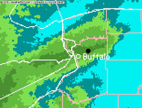 |
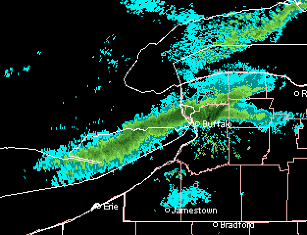
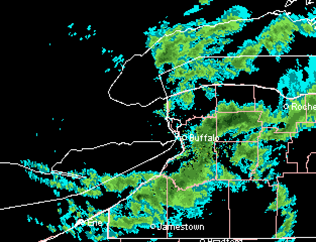
Radar precipitation accumulation
image as of 11 pm Dec 24th. Snowfall reports as of this time included: St Catharines.. nil |
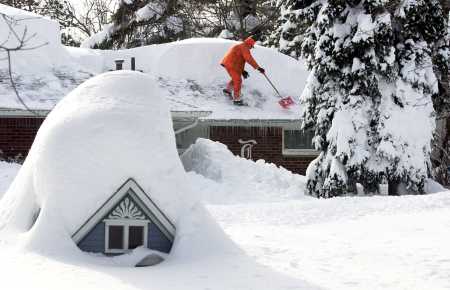
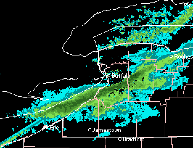
The band settled southward by late afternoon on Dec 24th as steering winds veered slightly to 250-260 degrees allowing the band to move into a more favoured orientation to pound Buffalo. And pound it did! The band settled over Buffalo and dropped 20 inches (50 cm) of snow between 5 pm and midnight for what was surely the snowiest Christmas Eve on record in the city. At one point, the snow was falling at a rate of 5" (13 cm) her hour! The 24 hr snowfall of 24.3 inches for Dec 24th was the 3rd heaviest 24 hr snowfall on record for Buffalo.. (but not for long!) The snow cover of 19" at Buffalo on Christmas morning established a new record for the deepest snow cover ever on Christmas Day...quite ironic considering up to this point, December 2001 was heading into the record books as the warmest and most snowfree December on record.
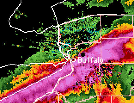
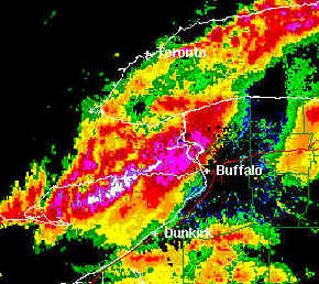
0430Z (1130 pm Dec 24th) NEXRAD radar image showing
250-260 snowsquall
band pounding Buffalo.
The band dropped 20 inches (50 cm) of snow in just 7 hours
between
5 pm and midnight Christmas Eve
Dec 25th - northern Niagara gets a taste
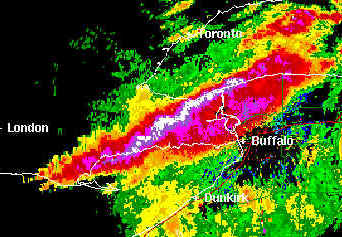 |
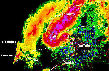
220 snowsquall affecting Niagara
3 pm Dec 25th At this point, Dunnville through Vineland
into |
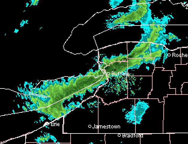
By the morning of the 25th, the snowband which had migrated over south Buffalo was on its way back north as steering winds began to back to a more southerly direction. The snowband moved over southern Niagara Christmas morning, reaching Welland by 10 am. The band continued slowly northward and locked into a 220 orientation through much of the day affecting mainly Dunnville through Fonthill and Thorold into St Catharines. A weather watcher near Simcoe reported 20 cm of snow for the day with 50 cm in Port Dover. It appears that about 10 cm fell in St Kitts and perhaps 15 cm in Vineland. Welland probably received another 5 to 10 cm from this event mainly during the morning as the snowsquall was heading north.
The snowsquall intensified again the night of Dec 25th and shifted into a 230 position, bringing more snow to Welland (see radar image below). About 15-20 cm of snow had accumulated in total by Wednesday morning over the city since Christmas morning.
 |
0500z (midnight Dec 26) radar image shows 230 band becoming organized over southeastern Niagara again including Welland, Niagara Falls and Port Colborne. |
Dec 26th - more snow for Niagara
 |
By the morning of the 26th, steering winds had backed into a 200-210 direction allowing the Lake Erie snowband to push over western Niagara and eastern Haldimand-Norfolk. Up to 40 cm of snow was reported just west of Simcoe with this activity. |
By the morning of the 26th, winds had backed into a 200-210 direction, allowing a couple of bands to affect western Niagara and eastern Haldimand-Norfolk. Unofficial totals of 40 cm were received just west of Simcoe Wednesday morning. Winds however would veer back into a 230 position for the afternoon bringing heavy snow back to southern and eastern Niagara. Snow began falling heavily in Welland around 3 pm as the band drifted in from the northwest. Another 15-20 cm of snow fell on the city between 3 and 8 pm before the band shifted out of the peninsula into Buffalo as winds veered into a 250-260 direction. This gave Buffalo another round of heavy lake effect snow the evening of the 26th when another 8 inches of snow fell on the city by 11 pm.
 |
 |
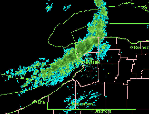
| 330 pm Dec 26th radar shows 230 squall hammering southeast Niagara once
again. Welland reported about 15 cm of snow between 3 and 6 pm with this band. |
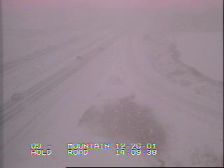
2 pm Dec 26th webcam shot from QEW at Mountain Rd (NW Niagara Falls)
gives a good idea about conditions associated with snowsquall radar image above. |
Dec 27th - Buffalo gets socked
By midnight of the 27th, the heavy snowsquall band slipped slightly southward
over the south towns of Buffalo as the squall locked in on a 260 orientation.
The band stayed there through the early morning hours of the 27th and dumped
heavy snow over West Seneca/Lackawanna areas. West Seneca reported 10 inches
(25 cm) of snow between midnight and 6 am and an incredible 30 inches in the 15
hours up to noon.
By daybreak on the 27th, the squall was pushing northward into the city of
Buffalo again as winds backed to 250 degrees. Buffalo airport picked up 16
inches of snow (40 cm) between 6 am and noon on the 27th.. giving them 36
inches on the ground. The NYS Thruway was closed by mid morning due to
numerous vehicles stranded by the heavy snow, and by noon a driving ban was
issued for most of Erie County including the city of Buffalo.
By 11 am the band was drifting northward over southern Niagara again
affecting the Port Colborne/Fort Erie areas with heavy snow as winds slowly
backed to a 240 direction. By 11.30 am the heavy snow band pushed up to
Welland as a meso-trof developed on the squall around Long Point, in effect
"whiplashing" the band north and pushing it into Welland through the noon
hour. (see image below)
 |
11.30 am Dec 27 - radar image showing snowsquall making northward push over southern Niagara |
By early afternoon the band began shifting southward again affecting extreme southeastern Niagara around Pt Colborne and Fort Erie into Buffalo and its northern suburbs as winds veered to a 240-250 direction. By mid afternoon the squall had shifted south out of Niagara, affecting mainly the south towns of Buffalo as winds locked into a 260 direction again behind the trof. The band stayed in the south towns of Buffalo Thursday evening giving heavy snow to Hamburg and Orchard Park before lifting northward again after midnight. (See Buffalo special weather statements on snow totals and snowfall records up to the evening of the 27th)
 |
4:30 pm Dec 27 - radar image showing 260 snowsquall south of Buffalo
|
Dec 28th - One last blast for everyone
Shortly after midnight on the 28th, the snowsquall band shifted back into
Buffalo and brought another round of heavy snow to the city. By 6 am another 15 inches of snow fell at the Buffalo airport, bringing the official snowdepth to
a record 44'' (112 cm).. surpassing the previous deepest snow cover of 42" set
back in early February 1977 after the Great Blizzard of '77.
The band continued northward early in the morning as winds veered to a 230
direction, pushing the snowsquall up to Welland, Niagara Falls and Thorold.
Heavy snow fell for a few hours in the morning giving another 20 to 30 cm of
snow to Welland before the band shifted southward again by 10 am back into
Port Colborne, Fort Erie and northern Buffalo.
 |
1045 am Dec 28: 240 snowsquall retreating southward after hitting central Niagara
|
By early afternoon, a trof line forming on the squall over eastern Lake Erie pushed one last band of heavy snow over southern Niagara up to Welland, before the band finally shifted out of the Peninsula by mid afternoon (see image below).
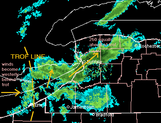 |
noon Dec 28: trof
over Lake Erie signalling shift of winds that would finally push squall activity south of
Buffalo/Niagara areas
|
By 2 pm the worst of the activity had slipped out of Niagara into western NY as winds shifted to a 260 direction behind the trof.. and the great lake effect storm of December 2001 was finally over in southern Niagara! In an incredible 5 days since Monday, anywhere from 90 to 150 cm of snow had fallen over southeastern Niagara.. one of the snowiest 5 day periods ever in this area. In Buffalo, the lake snows finally ended by 3 pm.. after an additional 10" (25 cm) of snow since morning. In total, an astounding 82" (200 cm) or almost 7 feet of snow fell on the city since Monday Dec 24th.. an unprecedented amount of snow in a city famous for its blizzards and snowdrifts.
 |
2pm Dec 28: It's
over! Westerly flow finally pushes squalls south of Niagara/Buffalo
|
Final snowfall totals
MAP OF ESTIMATED 5 DAY SNOWFALL OVER
NIAGARA**
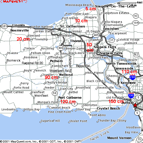
** snowfall estimated (based on radar/unofficial snow
reports)
Buffalo/Western NY Snowfall
In Buffalo, an incredible 82" (205 cm) fell over 5 days,
eclipsing the previous
snowiest month ever by over a foot!! (see below) For final snowfall totals from
the 5 day storm, see Buffalo's special snowfall statement.
RECORD REPORT
NATIONAL WEATHER SERVICE BUFFALO NY
557 PM EST FRI DEC 28 2001
...RECORDS CONTINUE TO BE BROKEN AT BUFFALO...
SNOWFALL TOTALS THROUGH 5PM TODAY HAVE REACHED HISTORIC VALUES AND
CONTINUE TO BREAK RECORDS. IN THE 5 DAY PERIOD SINCE CHRISTMAS
EVE...LAKE EFFECT SNOW BANDS HAVE DUMPED AN INCREDIBLE 82.3 INCHES AT
THE BUFFALO AIRPORT. TO PUT THAT TOTAL IN PERSPECTIVE...THE NORMAL
SNOWFALL FOR THE ENTIRE WINTER SEASON IN BUFFALO IS 93.5 INCHES.
TO UPDATE THE RECORDS:
GREATEST MONTHLY SNOWFALL - 83.5 INCHES DECEMEBER 2001
2ND GREATEST 24 HOUR SNOWFALL - 35.4 INCHES 6AM TO 6AM 12/27-12/28
GREATEST SNOW DEPTH - 44 INCHES AT 1PM DECEMBER 28TH
GREATEST DAILY SNOW FOR DEC 27TH - 21.9 INCHES
THE MONTHLY TOTAL FOR DECEMBER IS 83.5 INCHES WHICH MAKES IT THE
GREATEST MONTHLY SNOWFALL EVER IN BUFFALO. THE PREVIOUS RECORD WAS
68.4 INCHES IN DECEMBER 1985.
TODAY'S SNOWFALL AT THE NATIONAL WEATHER SERVICE MEASURED 26.2 INCHES
SINCE MIDNIGHT. AT ONE POINT TODAY...THE SNOW DEPTH AT THE AIRPORT
WAS 44 INCHES. THAT DEPTH SURPASSED THE PREVIOUS RECORD OF 42 INCHES
IN FEBRUARY 5-6, 1977. THE DIFFERENCE BETWEEN THE SNOW DEPTH AND
TOTAL SNOWFALL IS DUE TO SETTLING OF THE DRY AND FLUFFY LAKE EFFECT
SNOW.
IN THE 24 HOUR PERIOD ENDING AT 6 AM THIS MORNING, 35.4 INCHES OF
SNOW FELL AT THE AIRPORT. THIS IS THE 2ND GREATEST 24 HOUR SNOWFALL
ON RECORD. THE GREATEST 24 HOUR SNOWFALL REMAINS AT 37.9 INCHES
WHICH FELL DECEMBER 9-10, 1985.
HERE ARE THE TOP FIVE MONTHLY SNOWFALLS AT BUFFALO...
DECEMBER, 2001...83.5 INCHES
DECEMBER, 1985...68.4 INCHES
JANUARY, 1977....68.3 INCHES
JANUARY, 1985....65.9 INCHES
DECEMBER, 1995...61.2 INCHES
BY THE WAY...THE DAILY SNOWFALL FOR YESTERDAY, DEC 27TH WAS 21.9
INCHES...SHATTERING THE PREVIOUS RECORD OF 7.7 INCHES IN 1956.
NIZIOL/PFENDLER