Southern Manitoba will see a beautiful afternoon today with plenty of sunshine and highs approaching 0°C in southwest sections of the Red River Valley. This afternoon/evening would be a great time to get out and enjoy the warm weather; a cold front sweeping southwards is going to bring a drastic change on Thursday.
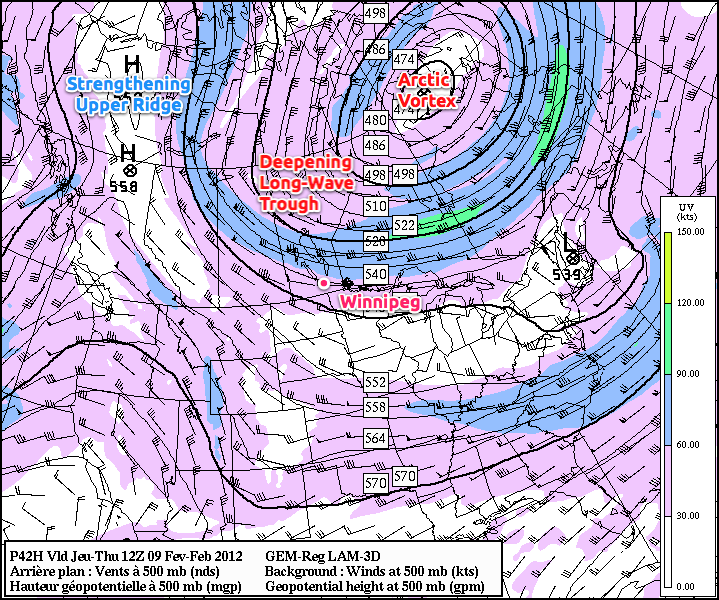
A strengthening upper ridge over the western portion of the continent will organize itself and amplify significantly today and tomorrow. By Thursday morning, it will stretch from Nevada northwards all the way to the Arctic Sea shoreline of the Yukon Territory. As a response, long-wave troughing will be enhanced over the central portions of the continent. Practically, this means that large-scale troughing will be induced in the arctic vortex and rotate around it.
In winter time, long-wave troughs are often associated with cold temperatures and incoming surface ridges of high pressure.
As this long-wave trough rotates from the Kivalliq region of Nunavut through Southern Manitoba, arctic air will be allowed to spill southwards. With this particular upper trough and associated cold front, there appears to be a significant push of cold air: temperatures on Thursday will only recover a degree or two from our overnight low of around -12°C, and temperatures will plummet on Thursday night. Currently, it looks like most areas in the Red River Valley will see overnight lows between -28°C and -32°C on Thursday night, with the colder temperatures east of the Red River and the warmer temperatures west of the Red River courtesy some light downslope winds over the escarpment. Like the previous cold front, very little precipitation is expected with it’s passage.
The normal daytime high for Winnipeg right now is -10°C. The normal overnight low is -20°C.
We’ll be under the influence of this bitterly cold air for a couple days before some warmer air advects into our region from the north again and we return to more seasonal values for Sunday and the start of the new week.