A fairly calm and uneventful week is in store weatherwise. Temperatures this week will be much warmer than the values experienced late last week.
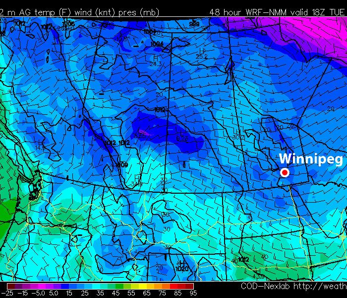
Weather conditions for the first half of this week will be pleasant. High temperatures on Monday and Tuesday will generally remain in the -2 to -6C range in Southern Manitoba with light wind speeds. However, those parts of Southern Manitoba that are mostly snow-free will see temperatures around zero during this time period. The stronger February sun will heat these darker, snow-free areas more easily than white snow-covered regions resulting in warmer temperatures. Regions west of the Red River Valley and south of the Trans-Canada highway are the most snow-free parts of Manitoba and therefore will be noticeably warmer than areas around Winnipeg (that have more snow cover). By Wednesday it appears that all of Southern Manitoba will get up close to the 0C mark as a light southerly flow brings in some warmer air.
The weather outlook for the end of the week is just a little bit cooler from that of the beginning of the week. Temperatures on Thursday and Friday look to remain around or slightly warmer than seasonal values (normal high is -9C). Models are currently showing the potential for some light flurries on Friday into Saturday, but other than that it doesn’t look like we have any chance of seeing snow this week.
Seven weeks of winter down, six to go.
Elsewhere in Weather News
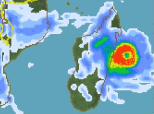
Super Cyclone Giovanna Threatens Madagascar
A very strong and dangerous cyclone named Giovanna has spun up in the western Indian Ocean this past Friday.
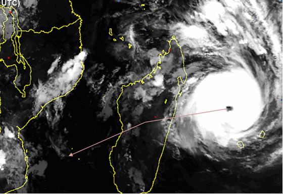
Giovanna is currently categorized as a category three cyclone (wind speeds of 160km/h) and is forecast to sustain its wind speed as it barrels towards the island of Madagascar. The combination of low wind shear and relatively warm waters of the western Indian Ocean is what has contributed to the rapid intensification of Giovanna. With the storm moving slowly towards the southwest, the landfall will take place on the Tuesday the 13th, bringing with it: torrential rains, a high storm surge and powerful sustained winds. The areas taking a direct hit with this cyclone will have a shot at receiving 250mm of rainfall (more than half of what Winnipeg receives yearly), wave heights reaching 24 feet and not to mention the sustained winds of about 190km/h. The storm may slowly intensify into category four, depending on whether or not an eyewall replacement cycle will occur before Giovanna makes landfall. This occurs when the cyclone’s thunderstorm bands circling around the eyewall use up some of the eyewall’s moisture and subsequently collapses the eyewall. Eventually, a new eyewall forms, strengthening the cyclone further and the cycle restarts.
The remnants of Giovanna will emerge into the Mozambique Channel and may re-intensify into a tropical storm. Unfortunately, this would bring heavy rains to Mozambique again, as they have already been plagued with torrential rains this season, more notably cyclone Funso (blogged about three weeks ago) which dumped significant rainfall on Mozambique’s coast not too long ago.
Elsewhere in Weather News has been provided by Matt