Colorado and Wyoming Battered by Storm System
A low pressure system that has brought tornadoes, hail and large amounts of rain to the western half of the United States this week has caused significant damage in Colorado and Wyoming. The warm, moist, air rushing north from the Gulf of Mexico made for a volatile atmosphere Wednesday and Thursday afternoon as it clashed with the Rocky Mountain range.

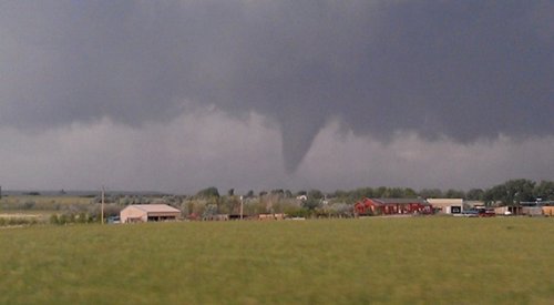
On Wednesday, storms dumped huge amounts of rain and hail in many parts of Colorado and Wyoming, prompting the National Weather Service to issue flash flood warnings in areas where storm cells were nearly stationary. Colorado Springs had a very intense thunderstorm pass through it where over 20cm of hail fell in the area and snow plows had to be used to clear roads and parking lots. Fire and rescue were also kept busy, saving people from submerged cars that had water up to their roofs. On Thursday morning residents there were surprised to see what one man described as a “scene that you’d only see in the winter”. A little further north, on Wednesday, was where most of the tornadic action was happening. In total five tornadoes were sighted touching down in the northern tier of Colorado, however only minor damage occurred and thankfully no injuries were reported. One tornado, reported as a landspout, even scooted to the north of Denver’s international airport, causing a scare to many passengers, but no damage was done to aircraft.

The harsh weather didn’t end there however. On Thursday the 7th, another round struck the same area spawning more tornadoes, dropping huge hailstones and more significant rainfall. On Thursday the heaviest of the rain occurred in extreme northern Colorado and south-eastern Wyoming, where it was greatly appreciated to help combat a moderate drought and wildfires present in the region. In total, the SPC received another 10 tornado reports, some being more serious, ranging from roofs being blown off to windows being blown out. Only one non life-threatening injury was reported with that round of tornadoes thanks to the great work of the National Weather Service who provided early warning.

As the trough spawning the severe weather shifts west, the region will experience cooler weather, thus, giving way to a stable atmosphere and calmer weather.
This system that that the western half of the United States experienced this week is expected to spawn severe thunderstorms in North Dakota and in southern Manitoba today.
