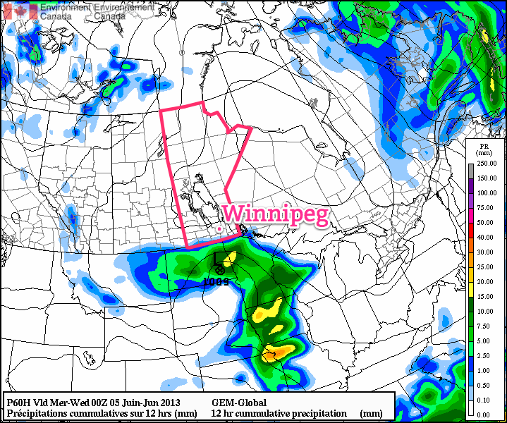
Below-seasonal temperatures will persist through the beginning of this week but that gloomy news will be offset by the fact that we should see plenty of sunshine over the next couple days. A disturbance tracking through the Dakotas will bring a chance of showers for the Red River Valley on Wednesday as it pushes the coldest air out of the Red River Valley and pushes us back towards seasonal temperatures.
19°C / 6°C
Sunny. Increasing cloud overnight.
18°C / 7°C
Mainly cloudy. Chance of showers near the U.S. border.
16°C / 7°C
Clearing in the afternoon. Channce of showers near U.S. border.
Monday
We’ll see nothing but sun today as a ridge of high pressure dominates the weather over the Red River Valley. Daytime highs will sit near 18 or 19°C. We’ll have another cool evening tonight with lows dipping to around 5°C.
Tuesday & Wednesday
Cloud will begin to push in on Tuesday as a low pressure system begins to work it’s way into North Dakota. The chance for precipitation in Winnipeg is very minimal, but closer to the international border it’s more likely that a shower or two will be seen. A sharp cutoff is expected from accumulating rain to nothing, and while the models have been trending towards keeping all the rain on the US side of the border, it’s important to note that around 10mm of rain is forecast for areas only 75–100km south of the Canadian border.

While just a few spits of rain is most likely for soaked communities in the southern Red River Valley, we’ll definitely be keeping our eyes on it. If the system ends up just a bit further north than forecast, areas such as Treherne, Morden, Gretna, Altona, Letellier & Emerson could see some light rain. For now, though, I’m expecting just a chance for a shower or two.
Rest of the Week
Heading through the rest of the week it looks like we’ll see couple of mainly sunny days on Thursday & Friday with temperatures climbing back to seasonal[1]. The weekend is worth keeping an eye on as another strong upper low is forecast to move into the region bringing showers and the potential for a few thunderstorms.
- The normal daytime high for Winnipeg at this time of year is around 22°C. ↩
