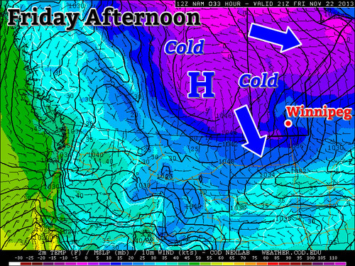
The chilly, below normal, temperatures are set to continue through the beginning of this weekend. There is a glimmer of hope though as a clipper system is expected to bring a bit of reprieve from the bone-chilling temperatures towards the end of the weekend, but this “warmer” weather will be short-lived.

Friday
-12°C / -22°C
Winds gusty, clouds clearing in the evening.
The day will start off as overcast, if not for lingering flurries still affecting Winnipeg from a weak system that passed last night. Winds will be stiff today coming from the north-west in the 25-30km/h range as the high pressure pushes south. Tonight you will want to make sure to crank the heat up as the low temperatures will bottom out around -22°C in Southern Manitoba, and even colder in the southwest corner of the province as the Arctic high slides down.
Saturday
-15°C / -18°C
Winds around 10km/h and mainly sunny skies. Cloud moving in overnight.
Saturday will be cold again. The Arctic high that pushed down will now be centered near the international border, which should keep us mainly cloud-free throughout the day but brisk temperatures will remain in place. Winds won’t be too strong from the west, perhaps 10km/h switching to southerly overnight. Lows won’t be dropping to levels as low as Friday night thanks to some cloud cover moving in associated with an approaching system.
Sunday
-4°C / -11°C
Could be a few flurries, winds south becoming west in the evening.
For Sunday there is a chance for some flurry activity as a clipper system slides by. Accumulations shouldn’t be higher than a few centimeters for the Red River Valley, but higher accumulations to the northeast of Winnipeg are possible. High temperatures for Sunday won’t be as cold as Saturday thanks to some warmer air aloft associated with the clipper but don’t be deceived, winds will be quite gusty, especially in the afternoon.
Looking ahead into the next work week there does not appear to be too much significant weather, once again – both the CPC (Climate Prediction Center) and the NAEFS point towards near average temperatures. In addition to that he models don’t show any significant systems, at least for the beginning of next week.
