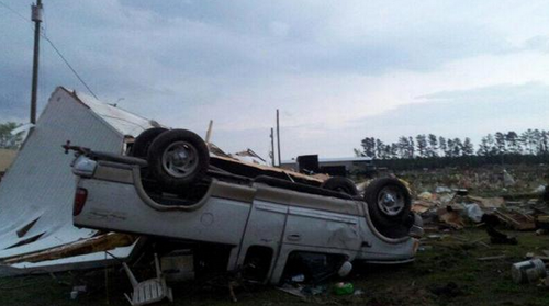
Tornadoes Tear through North Carolina
It was an active day severe weather-wise for parts of East Coast yesterday, where tornadoes, large hail and strong winds were all experienced. These severe storms were triggered by a shortwave racing across the mid-section of the US and approaching the East Coast. Moisture was plentiful streaming up from the tropics which promoted low cloud bases and sufficient amounts of Convective Available Potential Energy (CAPE). In addition to this, wind shear was significant enough to support supercells as well as an approaching cold front from the west acting as a trigger mechanism. Considering all of these, conditions were primed for supercells in North Carolina and Virginia.

Supercells quickly formed Friday afternoon across eastern parts of North Carolina and Virginia as the atmosphere destabilized. Elizabeth City appeared to be the hardest hit, likely by straight line winds and not a tornado. As of Friday evening, several injuries were reported because of the strong winds downing trees and power lines in the city. According to the SPC there were 10 different tornado reports which appeared to account for three different tornadoes. Fortunately, no injuries or deaths were reported to be associated with any of the tornadoes.
This event comes at the same time a significant negatively-tilted trough arrives ashore on the west coast. The trough is expected to bring severe weather from the US plains this weekend, to the East coast for the beginning of next week. Sunday through Tuesday look to be the most dangerous days where numerous tornadoes could touch down across Dixie Alley and the Midwest. As of Friday evening, the SPC had already issued a Moderate Risk, mentioning strong tornadoes in their discussion and suggesting a high risk (highest tier) upgrade could be in order in future updates.
With only 89 tornadoes reported in the US as of April 13th, that number could easily double within the next few days.
