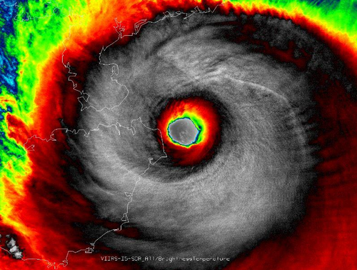
Another Super Typhoon Spins Up in the Western Pacific
The Western Pacific Ocean has been very active in the past few weeks, churning up numerous typhoons including its most recent – super typhoon Rammasun. Rammasun made landfall at least twice; once in the Philippines and China, respectively, during its trek across the Western Pacific.
The first landfall occurred southeast of Manila, Philippines, where it brought with it winds of 185km/h. Many precautions were taken ahead of this storm in the Philippines as it was the first typhoon to hit the country since super typhoon Haiyan. Over 500,000 people decided to ride out the storm in evacuation centres and plenty of warning (3 days) was given to residents before the typhoon made landfall. Despite the warnings, many homes could not be saved – as many as 7,000 as reported by authorities. Unfortunately 38 people died due to the typhoon in the Philippines.
After making landfall in the Philippines, Rammasun quickly strengthened with help from the very warm sea surface temperatures (SSTs) that approached 30°C in the South China Sea. With these warm SSTs conditions were primed for the storm to reorganize. Rammasun quickly developed a well-defined eye and became a super typhoon (category 4) as it approached China for a second landfall. The typhoon made landfall on Friday morning with sustained winds of 250km/h gusting to 280km/h on one of China’s southern provinces; Hainan. All modes of damage were possible with a storm of this intensity; including flooding rains, landslides and severe storm surge. It is still unclear how the region is doing in the aftermath of the storm as of Friday night. A report of 178mm of rain in the coastal city of Haikou (pop. 900,000) in 6 hours on Friday combined with expected storm surges of 20 feet in the general area made for big flooding/landslide concerns. Rammasun is expected make a turn for China’s mainland and die off this weekend, but not before bringing widespread torrential rains to the region.

More tropical storms are expected to spin up this week with possibilities in both the Atlantic and Western Pacific as depicted by some models. The strength or paths of these are uncertain.
