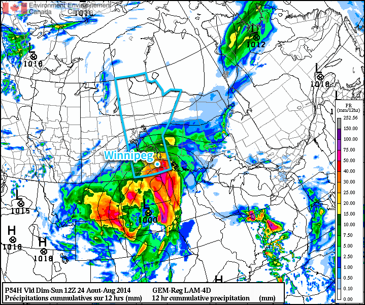
A major low pressure system developing in the United States and forecast to lift northwards into the Eastern Prairies through the weekend will bring generally unsettled weather ahead of a more cohesive area of precipitation that will move through on Saturday night.
Perhaps the single most important thing to keep in mind with today’s forecast is the fact that weather models have little consensus on what’s going to happen over the next few days other than the fact that there will be a large low pressure system that will impact an area somewhere between the Rocky Mountains and the Great Lakes.
That being said, it looks like the next several days will bring mixed weather to Winnipeg. Today will see a chance for scattered shower activity as a weak shortwave rolls across the Red River Valley, but nothing nearly as bad as what hit the city last night, where up to 80mm of rain fell in a rapid deluge through portions of the city that resulted in wide-spread flooding through the hardest hit areas.
Temperatures will climb to around 21 or 22°C this afternoon with a light wind out of the north. Tonight will be mainly cloudy with fairly light winds and a low near 15°C.
Saturday: The Low Approaches
Tomorrow will see mainly cloudy skies with a high of just 19 or 20°C. Winds will pick up out of the northeast to 30-40km/h as the main low pressure system for the weekend strengthens and lifts northwards through the Dakotas. By supper time, rain with the chance for embedded thunderstorms will spread through North Dakota into Southern Manitoba, reaching Winnipeg later in the evening.

The rest of Saturday night will be quite rainy with 10-20mm of rain likely across most of Southern Manitoba with localized amounts in excess of 30-40mm due to embedded convection in the precipitation shield. Some models, such as the RDPS pictured above, want to produce upwards of 50-75mm of rain, although at this point that’s likely overdone and a symptom of what’s known as “convective feedback” in the model, something that ends up causing the model to produce too much precipitation when there is widespread convection occurring. Temperatures will drop to around 15°C again with winds out of the northeast at around 30km/h.
More Unsettled Weather on Sunday
The weather on Sunday will likely improve as the low pressure system lifts through the Red River Valley and pushes off to our northeast. Rain will taper off in the morning and Winnipeg will be left under mostly cloudy skies in what’s known as the “dry slot” — the area behind the cold front located between the frontal precipitation and wrap-around precipitation denoted by descending dry air aloft. The high will climb to around 22°C with some strong northeasterly winds becoming light in the afternoon.
Significant instability associated with the low pressure system will be in place, and even with temperatures climbing only into the low 20’s, it will be enough when coupled with the significant moisture in place to present a risk for strong-to-severe thunderstorms. We’ll have more information in the comments on Sunday.
Things will begin to clear out on Sunday night as the temperature drops to around 13°C.
Into next week looks fairly benign with temperatures gradually returning towards normal by week’s end. There will be a couple cool nights in the coming week with overnight lows dipping into the single-digits.
We’ll be keeping an eye on this system as it develops; slight alterations in the track of the system could dramatically impact forecasts, so if any changes are needed we’ll note them below in the comments. All in all it will be a mediocre weekend followed by an improving week.
