The shot of cool air that worked its way into Winnipeg in a somewhat unwelcome fashion yesterday will remain entrenched over the region for the next few days, resulting in seasonal to just below seasonal temperatures heading towards Halloween. Fortunately, the weather looks to be drier, and it’s unlikely that we’ll see much more of the white stuff.
Today will remain mainly cloudy but, unlike yesterday, our temperatures should manage to sneak just a little bit higher, to around 4 or 5°C[1] with substantially calmer winds. A weak low pressure system skirting along the U.S. border will bring a slight chance of showers to areas in the vicinity, but it looks like rain will likely remain States-side. A chilly night ahead tonight as some of the cloud starts clearing out and we head to a low of around -1°C.
Thursday will be a cool day as an Arctic ridge builds southeastwards into the province. Skies will be partly cloudy with no real chance of precipitation and it will be quite cool as temperatures are only expected to climb to 1 or 2°C. The overnight low will dip down to a very chilly -6 or -7°C under mainly clear skies. Thursday night looks like the low point for our temperatures over the next while.
A Chilly Halloween
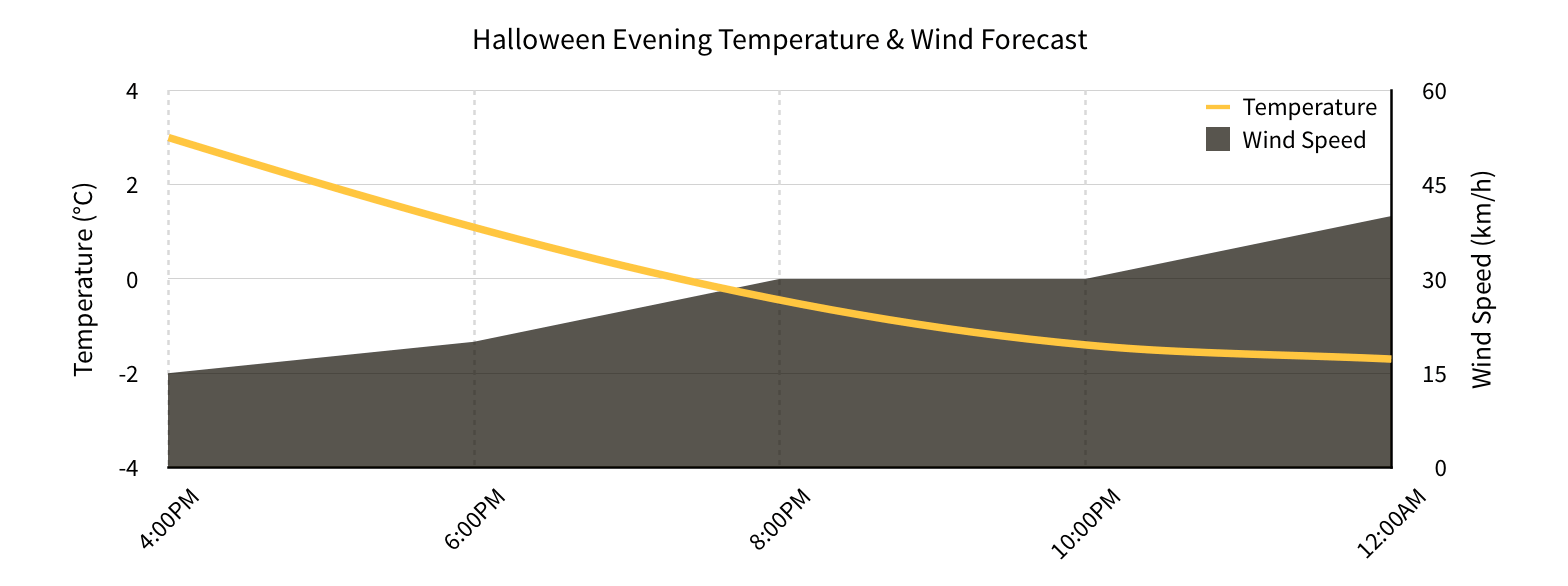
Temperatures will begin to moderate on Friday but it will still be a chilly Halloween evening. The day will start off mainly sunny, but as the Arctic ridge slides off to our east and another low pressure system begins approaching from the west, more cloud will begin pushing in from the west. The temperature will climb to around 4°C by the afternoon and, thanks to the increasing cloud, gradually cool off through the evening.

Alongside the increasing cloud coverage will come gradually increasing winds. While early in the evening they’ll be only around 15-20km/h, the wind will gradually increase to 30 gusting 50km/h by mid-evening and then further increasing to 40 gusting 60km/h by late in the evening. The temperature will drop to around -2°C overnight. The wind will make it feel rather cool, despite the fairly seasonal temperatures expected.
Unsettled Weekend
The weekend looks somewhat unpleasant as warmer air tries to work its way back into the province. Saturday looks quite windy and fairly cloudy as temperatures climb into the upper single-digits. Sunday brings some uncertainty as a larger system develops in the northern United States and lifts northeastwards. Temperatures will remain slightly above normal, however it is possible that it ends up being a fairly rainy day. There’s significant disagreement with the models on the timing of this system, though; some bring rain in early on Sunday while others delay the rain until Monday. We’ll be sure to keep an eye on this system as it develops and we’ll take a closer look at it in Friday’s post!
- Seasonal highs for late October in Winnipeg sit near 5°C. ↩
