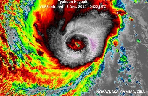
Super Typhoon Hagupit Heads towards the Philippines
The Philippines are bracing for a very strong typhoon that is expected to make landfall this weekend. Hagupit, which was formerly known as a super typhoon (with winds exceeding 240km/h) has lowered in intensity but is still considered dangerous. The slight weakening was due to an eye wall replacement that took place. As of Friday afternoon, the typhoon was located in the West Pacific and heading west towards the central islands as well as the main islands where Manila is located.
This region has seen numerous strong typhoons in the last five years including super typhoon Haiyan, which made landfall in the Philippines 13 months ago just south of where Hagupit is expected to make landfall.

Yesterday, Hagupit had already begun lashing the islands with its outer rain bands. Evacuations were underway this past week where around 500,000 people have already been evacuated from areas most at risk including along small coastal fishing villages and in unsafe structures. The typhoon is expected to make landfall tonight near Sorsogon City, and will likely reach a high end category three or low end category four equivalent storm, bearing sustained winds of around 200km/h. Storm surges are sure to be a problem, especially along the front right quadrant of the typhoon, where surges could exceed 10 feet. Rainfall will also be of concern since Hagupit is fairly slow moving and will be able to drop copious amounts of rain. It is expected that the hardest hit areas, around where Hagupit makes landfall, could see around 500mm of rainfall.
After Hagupit emerges back over waters, the waters of the South China Sea, it is unclear as to where it will go and what its strength will be. A few of the forecast models show it holding together and continuing straight west with at least tropical storm force winds but sea-surface temperatures are not ideal for intensification in the region.
