Winnipeg, and many other regions in the Red River Valley, received the most significant rainfall so far this year yesterday as an area of moderate rain moved into the province from North Dakota and stalled out for much of the day. Rainfall totals in most places were near 20–30mm with slightly higher amounts in the southwestern Red River Valley:
| Location | Rainfall Total (mm) |
|---|---|
| Letellier | 41 |
| Altona | 37.6 |
| Morris | 34.2 |
| Winkler | 29.8 |
| Steinbach | 27.8 |
| Winnipeg | 24 |
| Dugald | 22 |
| Elm Creek | 12.6 |
| Portage la Prairie | 9.6 |
The Altona/Letellier areas seem to be the winners for total rainfall with almost 1.5” of rain in total. Unfortunately for farmers who are still working at getting seed into the ground, there won’t be much of a reprieve from wet weather before more rain is on the way as another major low pressure system is hot on the heels of the previous one and is set to bring a whole host of unsettled, pleasant and stormy weather for the May long weekend.
Pleasant Friday, then Downhill
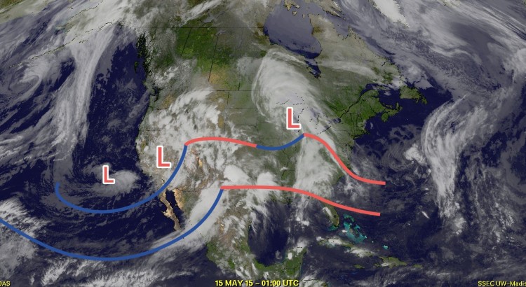
Today will be a very pleasant day across the Red River Valley with mainly sunny skies and temperatures climbing into the high teens under partly cloudy skies. Winds will be fairly light out of the northwest. Friday night will see temperatures drop to around 7°C under clear skies. The nice weather won’t last too long, though, as a potent low pressure system moving into the Northern Plains of the United States tonight will result in cloud and some light rain spreading across Southern Manitoba early on Saturday. The heaviest rainfall will hold off until much later in the day, however, as this system will end up being strongly driven by convection.

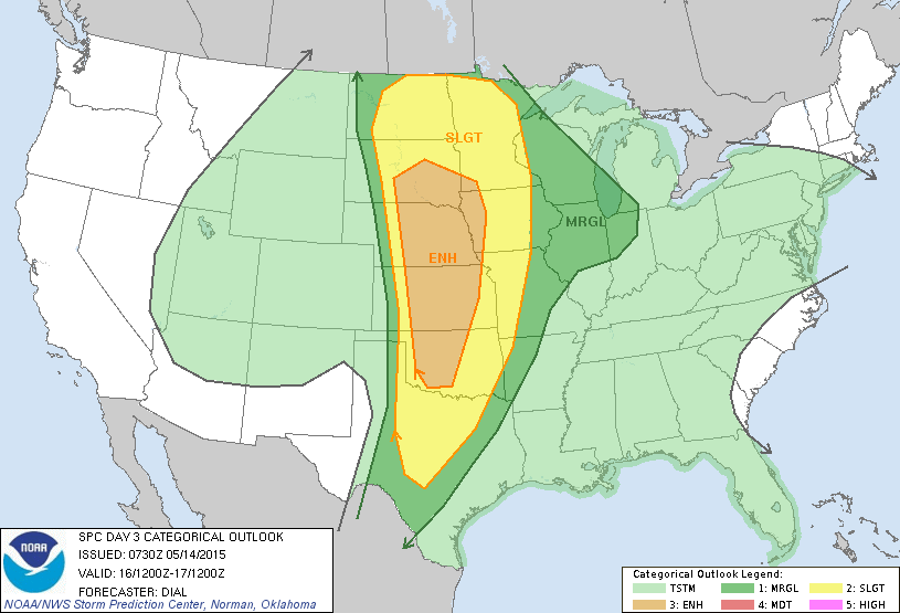
The SPC[1] in the US currently has a slight risk of severe thunderstorms in their outlook for Saturday scrunched right up the Canadian border. Further north in our area, it looks like an initial shot of some showers associated with elevated convection will lift through the region early in the day. Temperatures will warm towards the 20°C mark with an increasing risk of showers or thunderstorms.
Later in the afternoon, best indications at this point are that an area of thunderstorms will initiate in North Dakota and push northeastwards through the Red River Valley. It looks like precipitation will most likely be showers or weak thunderstorms, however the outside chance exists that an isolated severe thunderstorm may be seen. A thunderstorm outlook later will be issued later today covering all of Southern Manitoba.
A few showers will be likely through the overnight hours as the temperature drops to 9°C or so.
Sunday will be the most significant precipitation day with rainfall intensifying through the morning into the afternoon. There’s some uncertainty as to where the western cut-off will be for the rain, but general consensus at this point is that the entirety of the Red River Valley will see rain on Sunday.[2] Total accumulations are hard to nail down at this point, but look to be in the 25–50mm range.
Things take an unwelcome turn on Sunday evening as colder air works its way into Southern Manitoba on the back-side of the system. Rain may become mixed with or switch over to snow as it begins tapering off. No significant snow accumulations are expected. Temperatures will drop off to around –3°C on Sunday night with winds gradually tapering off.
Holiday Monday A Cool Improvement
Looking ahead to the start of next week, it looks like Monday will mark the transition out of this active pattern we’ve been in. Sunny skies and exceptionally cool weather look to be on tap with highs struggling to get to even 10°C[3]. Conditions will improve over the subsequent days with drier weather and temperatures returning to the seasonal mark.


For our first update regarding this system, attached is the preliminary convective outlook for Saturday. In general, best chance of severe thunderstorms exist south of the border with a fairly wide area of non-severe thunderstorm activity possible south of a line extending from SE Saskatchewan through the Interlake and into NW Ontario. These storms will likely be later in the day or in the evening and be elevated. There’s a chance for some surface-based thunderstorm activity through the southern Red River Valley into the Whiteshell, but the storms pose just a marginal threat of being severe as much of the energy available from this system will be intercepted by the more vigorous convection in North Dakota and Minnesota.
The thunderstorm activity from the US will lift northwards in the evening and weaken, providing rain with the chance of some thunderstorm activity across Southern Manitoba into the overnight period.
For our second update regarding this system, I have to apologize for not having any graphics available. I’m having some technical problems I can’t quite figure out and my outlooks are being corrupted when uploading them to the web. So text will have to do…
System is rapidly developing this evening with rain blossoming in the Dakotas and spreading northwards. Portions of southwest Manitoba has already seen 2″ of rain thanks to convection this evening with more on the way yet. Rain is spreading eastwards and we’ll see anywhere from 5-20mm through the RRV overnight.
Precipitation will be generally lighter across most regions tomorrow morning, driven more by a cold front pushing southeastwards than systems coming up from the south. A very potent low will advance through North Dakota and spread heavy rain into the Red River Valley. At the same time, the advancing cold front will change precipitation over to snow for areas to the west and north of the RRV. The snow will slowly advance SE with the cold front, arriving in Winnipeg in the evening. Total rain for the day will likely be 20-30mm with 2-4cm of snow most likely for Winnipeg Sunday night. Some solutions draw more snow into Winnipeg, but I’m going to hold out faith that we’ll stay warm enough to not get too much. Snow amounts will decrease to the SE of Winnipeg.
The heaviest snow will occur along an arc from east of Melita through Brandon, Gimli & Bissett. Snowfall totals will likely fall in the 10-20cm range by the late evening. Along the transition from rain to snow, there will be a chance for some freezing rain or ice pellets as it pushes southeastwards through the day.
Everything tapers off to some light snow Sunday night that will move out of the province on Monday.
By the time all is said and done, Winnipeg will likely see around 2″ of rain followed by a light dusting of snow.
Very Strong Winds for Sunday
A big story tomorrow will also be the very strong northeasterly winds expected to develop. A very tight pressure gradient on the northwest flank of the low pressure system is expected to bring widespread 50 gusting 70km/h to 60G80km/h winds with the potential for some 70G90km/h winds along a line through Brandon and Gimli. The strong winds will produce significant wave action on the lakes as well as produce blowing snow in areas that see falling snow. The strong winds will ease slightly Sunday night and taper off on Monday.
All in all, a pretty terrible day tomorrow. Bundle up and get the warm drinks ready!