Unsettled Ride Towards Summer Temperatures
Winnipeg is set to see summer-like heat slowly build into the region over the coming week, however the unsettled weather brought about by the zonal flow that’s been in place over the past several days will continue doing its thing for another few days yet before more stable conditions build into Manitoba.
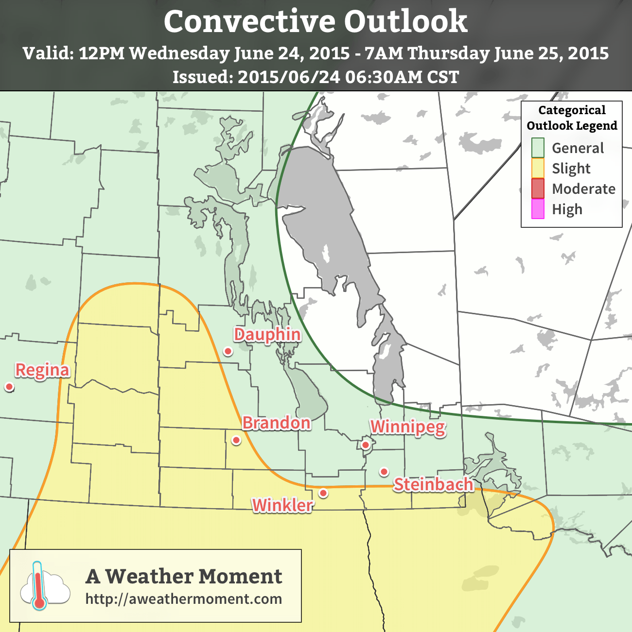
Today will be a similar day to yesterday with daytime highs in the low 20’s through the Red River Valley and fairly light winds. Dew point values are expected to climb to around 16 or 17°C today, which when combined with a bit of daytime heating will provide some fuel for scattered thunderstorm mid-day through the afternoon. Applying the MIST principles:
- Moisture: As mentioned, dew point values are expected to rise to around 16 or 17°C thanks to some pooling along a weak trough through the region coupled with an easterly to southeasterly flow tapping into higher dew points to the southeast.
- Instability: Moderate mid-level instability will be in place thanks to a shortwave moving through the region. CAPE values, driven largely by the favourable thermodynamics in place, will be in the 1000–1500 J/kg range.
- Shear: Bulk shear of 25–35 kt will be marginally supportive of organized thunderstorms. Directional profiles will be somewhat anomalous, with easterly low-level winds backing to the northwest/west thanks to the approach of an inverted trough. End result is that, particularly through western Manitoba, storm motion will likely be quite slow, making rainfall accumulations a potential hazard with today’s storms.
- Trigger: This may be the weakest aspect of today’s storms. A very weak frontal trough will be in place, alongside a weak upper-level shortwave and impinging inverted trough. Lack of any strong focus will likely be biggest inhibitor to widespread storm organization and will diminish the severe storm potential for the day.
With those factors taken into account, we’ll likely see scattered thunderstorms across much of Southern Manitoba today, however the threat for severe thunderstorms will be quite low with just an isolated marginal severe storm risk. The exception to the rule will be in the southwest portion of the province closer to the inverted trough. Shear profiles have strongly backed surface winds with a backing profile, making slow-moving storms more likely there. With adequate bulk shear to support & ventilate the storms, heavy rainfall is a heightened risk in that area due to slower storm motion.

That said, we’ll see mixed skies today alongside our chance for thunderstorms. Expect the storms to taper off this evening as we head to a low near 13°C.
Thursday will be off to an unsettled start as another disturbance rolls through the region and brings a chance for showers or thunderstorms through the morning hours. After that, we should see some clearing skies as the temperature heads on its way to a high in the mid–20’s. Expect clear skies Thursday night with a low near 14 or 15°C.
Friday looks gorgeous with sunny skies and a high near 27°C. Mainly clear skies should prevail Friday night with a low 12°C.
A Look Ahead to the Weekend
The weekend is looking like a bit of a mixed bag. The warmth will continue to build into the Prairies, particularly in the Western Prairies as the upper ridge begins building in. Here, Saturday looks potentially wet with the possibility of a low pressure system riding down the upper ridge through Southern Manitoba which would bring another batch of rain to the region. Sunday looks nice by all accounts with a fair amount of sun and highs climbing into the upper 20’s!
