True summer warmth is on the way for Winnipeg with temperatures soaring into the upper 20’s and overnight lows in the mid- to upper-teens. However, alongside the warmer weather, multiple threats for severe thunderstorms will return to the region.
Friday
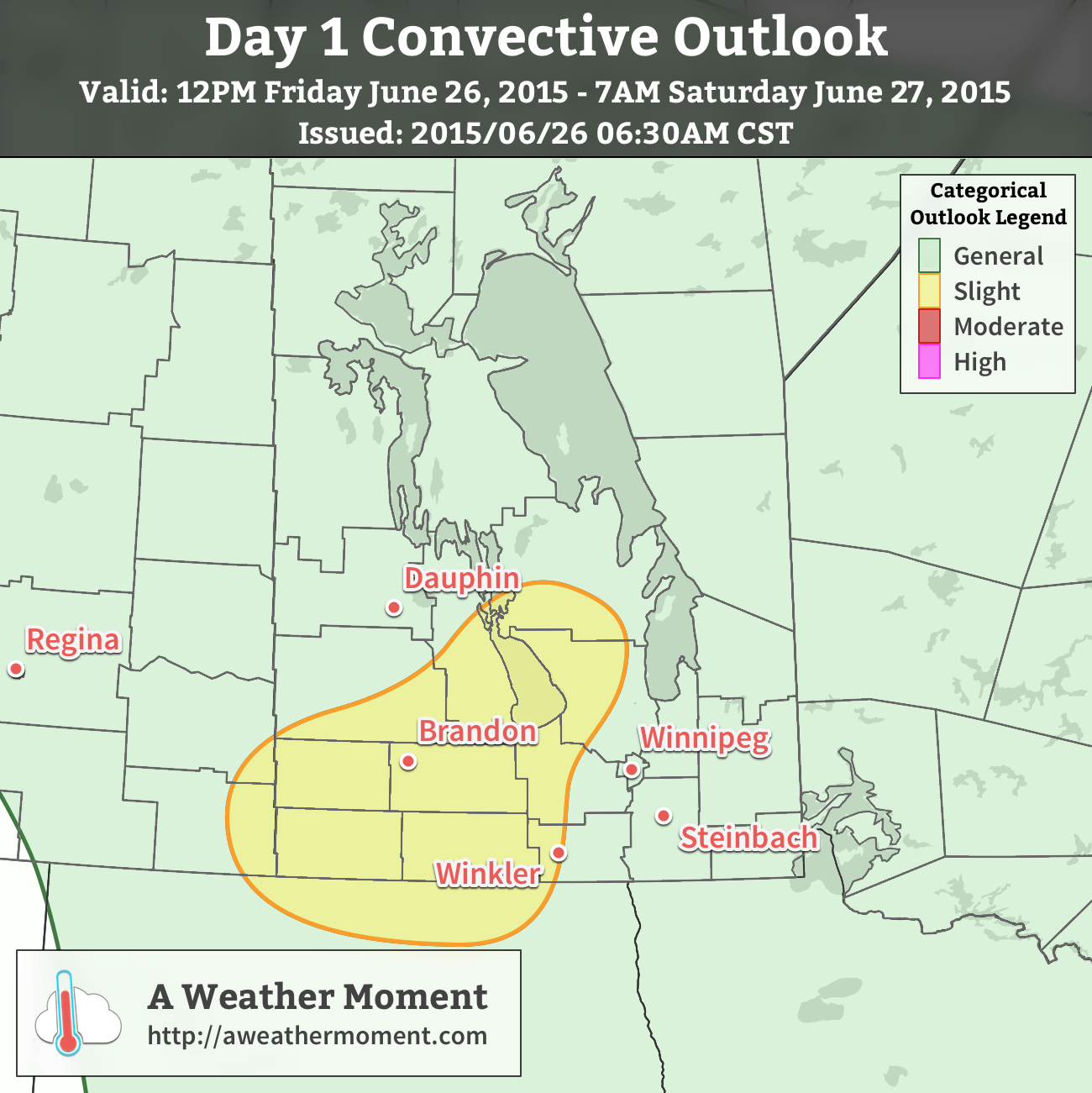
Today will be a very warm day with temperatures climbing into the upper 20’s and light winds. Skies will start off sunny, and then we’ll see some afternoon cloudiness develop over the valley alongside some scattered thunderstorms. There’s little organizational feature, so it will be rather hit and miss as to whether you see a thunderstorm where you are or not.
Further north and west, there will be a slight risk of severe thunderstorms. MUCAPE (a measure of instability) values of 1000–1500 J/kg coupled with 25 kt of bulk shear will be substantial enough to support the organization of severe thunderstorms. A mid-level disturbance will slump to the southeast into Parkland Manitoba and the Interlake by early- to mid-afternoon and provide a focus and trigger for thunderstorm initiation.

Severe thunderstorms are not expected widespread, but isolated severe cells are possible. Over the western sections of the slight risk area, large hail and heavy rain will be the primary threats. Those threats also exist further east in the slight risk area – mainly along the Red River Valley escarpment into the Interlake – there will also be a slight chance for funnel clouds or weak landspout tornadoes due to the additional “spin” provided by a shortwave moving through.
Temperatures will remain quite warm overnight with lows dipping to just around 16 or 17°C.
Saturday
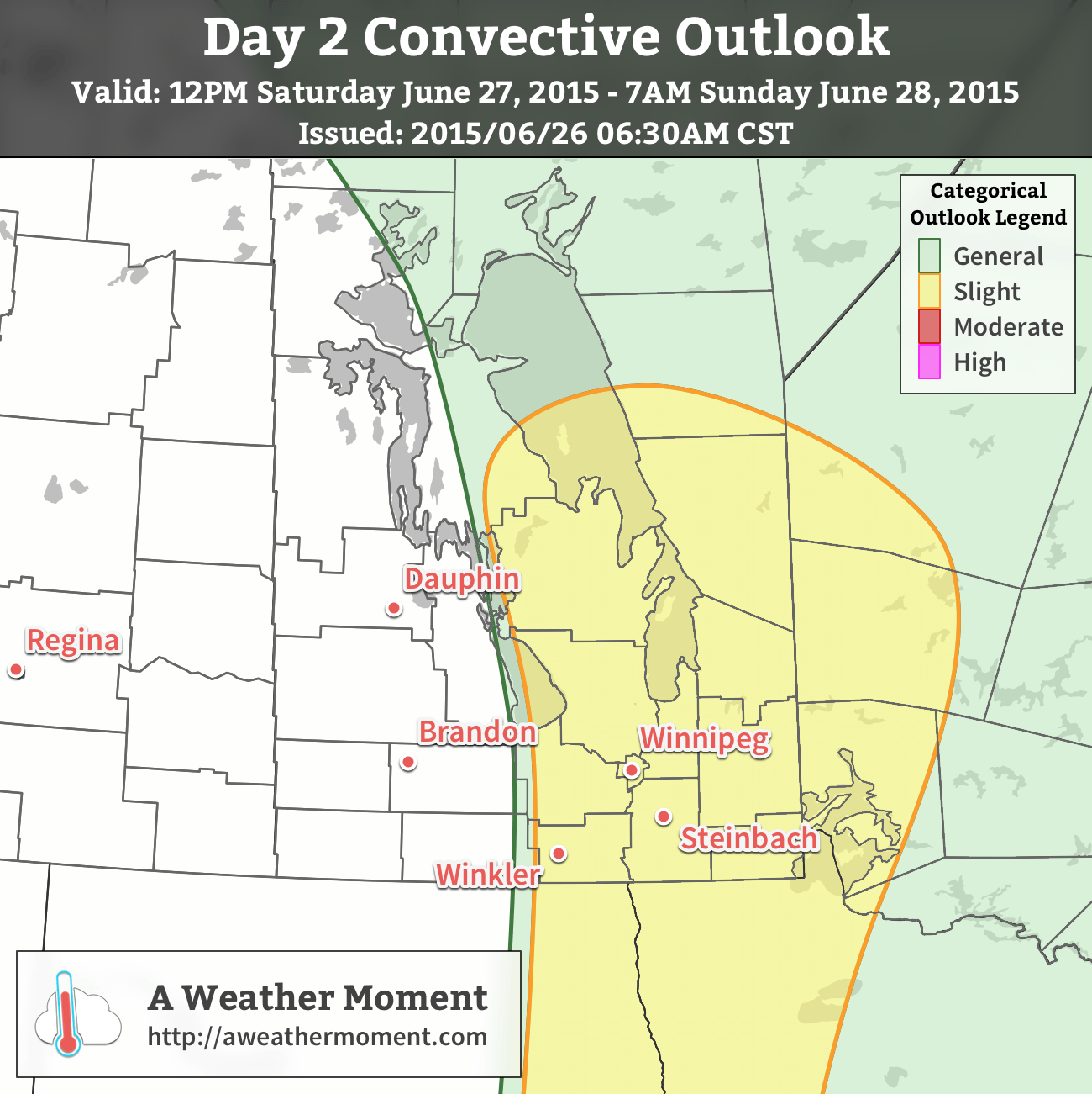
Saturday will see a severe thunderstorm threat return to Winnipeg as more humidity pushes northwards ahead of a significant shortwave and associated trough line approaching from Saskatchewan. Dew point values are expected to climb into the upper teens producing MLCAPE values over 2000 J/kg. Strongly veering wind profiles coupled with over 40 kt of bulk shear will result in a moderate severe thunderstorm threat. While some models show surefire convection, there may be issues with a capping inversion depending on exactly how warm it’s able to get.

Given the uncertainty, a slight risk for severe thunderstorms exists on Saturday through the Interlake into the Red River Valley. As the issues with the capping inversion become clearer, the threat may be upgraded to a moderate risk.
The primary threat with storms on Saturday would be damaging hail, strong winds and torrential downpours. Shear profiles are supportive of supercells, and while it’s not considered a significant likelihood, it’s important to remember that supercell thunderstorms can produce tornadoes.
Regarding non-thunderstorm weather on Saturday, temperatures will climb into the upper 20’s which will feel more like the low- to mid–30’s with the increased humidity. The winds will be out of the south at around 20km/h. Skies should clear on Saturday night as temperatures drop to the mid-teens.
Sunday
Sunday will finally see both warm temperatures and quiet weather. Temperatures will climb back into the upper 20’s with winds out of the north at around 15–25km/h. With those northerly winds, the humidity will be quite a bit more comfortable than on Saturday.
Some thunderstorm activity will occur in Manitoba on Sunday, but it will most likely be constrained east of Lake Winnipeg & down into the northern Whiteshell. The thunderstorm activity does not look like it has an organized severe threat.
Expect temperatures to dip back to the mid-teens on Sunday night.

Here’s our updated convective outlook for today. Little change from the Day 2 outlook issued yesterday morning. Main difference has been a slight shifting of the slight risk area westwards to include portions of the western Red River Valley escarpment and elimination of a bit of area in Northern Ontario.
Discussion is the same as before (see: http://aweathermoment.com/…/warm-weekend-brings-severe-th…/…). Primary threats today are supercell thunderstorms produing large hail, strong winds and potential flash flooding from heavy rain. Tornado threat is non-zero, but low-level shear is less favourable. Remember, though: any supercell thunderstorm is capable of producing a tornado.
We’ve also merged our slight risk with the NOAA NWS Storm Prediction Center’s slight risk area. It’s worth noting that they have upgraded the threat to enhanced in North Dakota; while I think the heightened risk is perfectly valid for areas south of the border, the number of storms/coverage of the storms later today may not warrant that high a threat north of the border.
Even if there are not numerous storms, remember that these thunderstorms today have the potential to be powerful, dangerous thunderstorms. Stay sky aware and stay alert for any warnings issued by Environment Canada.