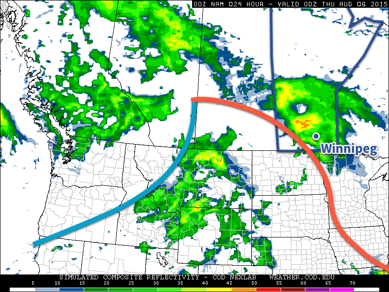
The pleasant spell of cooler, drier weather is coming to an end today as a warm front pushing eastwards across the Prairies brings unsettled weather today and then a deeper southerly flow which will help the heat and humidity slowly build up through the region into the end of the week.
Wednesday
Today will be the first active day of the week as a warm front approaches from the west and pushes through the Red River Valley later this afternoon & into the evening hours. This system will spread showers and thunderstorms across southwestern Manitoba this morning and gradually push them towards the valley through the day. The rain will likely hold off until late in the afternoon or early this evening here in Winnipeg. Temperatures will climb into the low 20’s across the valley with winds picking up out of the south-southeast to 20–30km/h with some gustiness on top of that by mid-to-late afternoon.

With the showers there will be a slight chance of an embedded thunderstorm…if we can manage some heating through the day with a bit of sunshine. If it ends up being overcast for a large area ahead of the front, the thunderstorm activity will likely be fairly mild with little-to-no chance of severe weather. On the other hand, if some sunshine manages to heat things up a bit, there will be a very borderline risk of some marginally severe wind or hail with some of the storms. That said, it doesn’t look particularly likely that we’ll see too much thunderstorm activity and, rather, we’ll see more moderate shower activity. The exception to this rule will be over southwestern Manitoba where there will be a slight risk of severe thunderstorms with main threats of large hail and damaging winds.
By the time things clear out late in the evening, most places will likely have seen around 5–10mm, but localized amounts of 10–20mm are possible. Temperatures will drop to lows in the mid-teens tonight.
Thursday
Thursday will be a muggier day with temperatures climbing into the mid–20’s. There will be some sunny breaks, but skies look to be trending towards the cloudier side of things. Another disturbance begins pushing into our region later in the day, which will bring another chance for showers or thunderstorms mid-afternoon into the evening hours. Temperatures will dip to the mid-teens again on Thursday night with a continued chance of shower activity.
Friday
Friday will see a more organized thunderstorm threat return to Winnipeg & the Red River Valley as the main upper-level disturbance swings through the province. Temperatures will climb to around 26°C or so with any leftover humidity getting flushed out by drier westerlies at around 30km/h. We may see some pop-up thunderstorms through the day, but at this point they don’t look like they’ll bring any severe weather. Friday night will see temperatures dip back to the mid-teens with a chance of some wrap-around shower activity pushing into the Red River Valley form the north on the back-side of the departing upper low.
Weekend Looks Pleasant
Looking ahead, the weekend looks great with high temperatures in the upper 20’s, relatively comfortable humidity, and little in the way of precipitation expected thanks to a ridge of high pressure working its way across the Prairies. Finally, rainy weather during the work week turning beautiful for the weekend!
