
Winnipeg will see seasonal weather for Christmas Day with a slight chance elf some flurries as some cloud works its way across the region. Temperatures will plummet this weekend, however, as the first large Arctic ridge of the winter builds over the Prairies.
Merry Christmas from the crew here at A Weather Moment! We hope that you have a great few days however you spend them! Shift workers, thank you for continuing to do your work through the holidays so we can continue having the services we rely on!
Today will be a fairly unremarkable day with seasonal weather through Winnipeg and the Red River Valley. A weak disturbance moving across the province will bring mixed skies with just a very slight chance of some scattered light flurry activity as temperatures recover to around -12°C by early in the afternoon. It’s downhill after that, though, courtesy a building Arctic ridge that will push the cloud out of the region and bring colder air across the Prairies.
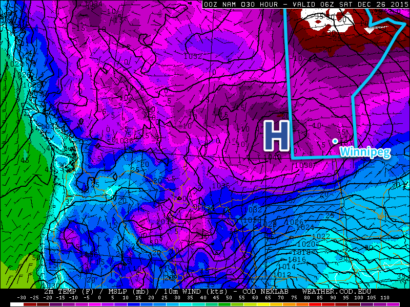
Temperatures will fall to around -25°C tonight. Saturday will bring a few clouds through the region and significantly colder temperatures with daytime highs of just -18 or -17°C. These highs are around 5°C below average for this time of year. Tonight will see temperatures fall to around -23 or -24°C with some scattered cloud.
Sunday will be a final cold day as the ridge slides to our south and southeasterly outflow winds set up over the region. Expect mixed skies and a high near -16°C. A developing low pressure system is forecast to begin spreading warmer air and cloud eastward across the Prairies on Sunday night, signalling an end to the cold snap. Temperatures will drop to around -24°C in the evening before a warming trend kicks in with the cloud. At this point, it looks like temperatures will rise to around -15°C by Monday morning. There’s some uncertainty with this system, though, and if it’s slower to develop than expected, the warmer air may not arrive until during the day on Monday.
Long Range
Next week is looking fairly nice, although the sun may be a rare site. With the arrival of the next system on Monday, warmer weather will move into Winnipeg for much of the remainder of the week. Daytime highs will likely be a bit above seasonal, around the -10°C mark, but those warmer temperatures will once again be accompanied by a lot of cloud. Much of the week will bring the potential for some flurries, but a more organized system looks possible mid-week that could bring another 4-8cm of snow to the region.
A brief shot of cold air rounds out the end of the week before a surge of very mild air moves in for early January, with the prospect of highs near the 0°C mark returning. So if we just need to make it through this one cold snap, then we’re back on a trend towards very mild winter weather!