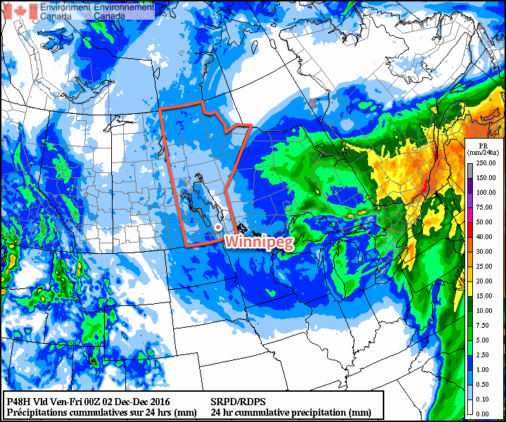
Despite moving onto the back-side of a massive low pressure system with gusty northerly winds, Southern Manitoba won’t be falling into a deep freeze; the cooler temperatures moving in place will instead be cooler but still above typical seasonal values. Alongside the minor cool-down, the region will be dealing with periods of light snow as the low pressure system that brought a mix of rain and snow over the past couple days slowly moves off into Eastern Canada.
Skies will be mainly cloudy over the coming few days, with a slight chance of the odd ray of sunshine on Thursday and a better chance of skies becoming mixed on Friday. Temperatures will be relatively steady through the week as well, with temperatures steady near 0°C today giving way to daytime highs near -2°C on Thursday and Friday. Lows will fall just a few degrees below the highs, with lows near -5°C on Thursday and Friday. On the off chance that some clear patches show up at night, temperatures have the potential to plummet closer to the -9 or -10°C, but those values won’t be seen underneath cloudy skies.

Today will bring periods of light snow to the region, tapering off to scattered flurries tonight and through the next couple days. By Friday, any flurry activity should be relatively isolated. No notable accumulations are expected from the snow over the coming days.
Winds will be out of the north at 20-30 km/h through the day with a few gusts on top of that. The wind will diminish tonight, followed by light winds for Thursday and Friday.
November Looking To Take Top Spot As Warmest on Record
Winnipeg continues it’s incredibly warm winter with non-stop above-normal temperatures.
The average daily high temperature for November 2016 now sits at 7.4°C, beating out the previous record of 7.1°C set in 2009. The average daily low temperature for the month is now at -1.0°C, crushing the previous record of -3.2°C set in 1923. Combine the two, and the average daily mean temperature sits at 3.2°C, beating the 117 year old record of 1.3°C set in 1899 by almost 2°C.
The unprecedented warmth will fade as we head into December, though; all long-range guidance is suggesting a return to seasonal temperatures in the coming week. While colder air does look like it will begin working its way into the Prairies in the coming weeks, so far it appears most of it will remain west of Manitoba, leaving us with a continued stretch of near-seasonal temperatures ahead.
Winnipeg’s seasonal daytime high is currently -6°C while the seasonal overnight low is -15°C.
