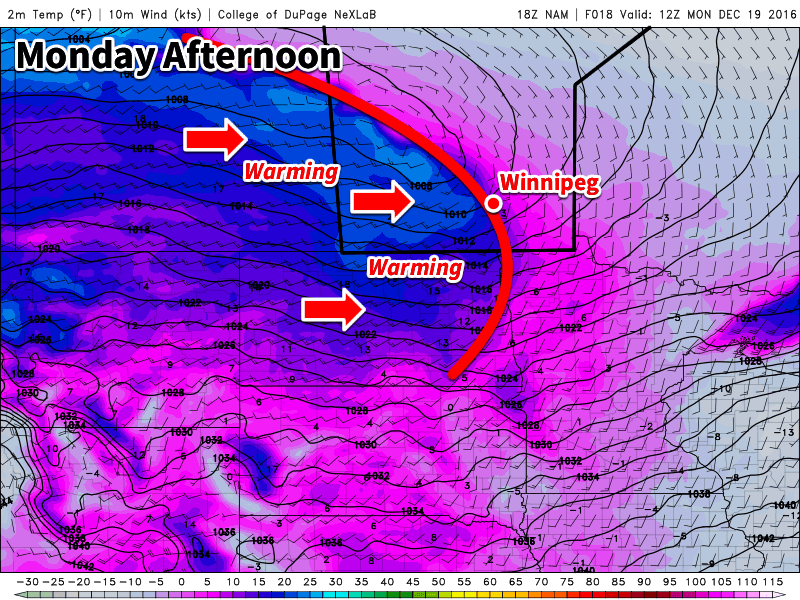
A much-needed break from the past week of frigid arctic air has finally arrived. As you read this post, much warmer Pacific air is flooding across southern Manitoba and should be felt in the Red River Valley by early- to mid-morning.
This Week
Today’s weather will feel downright mild compared to the frigid conditions we’ve been experiencing for the past week. Temperatures will climb well into the minus single digits across southern Manitoba, with most locations having high temperatures just a few degrees below freezing. Some spots downwind of the Manitoba escarpment (e.g. Morden and McCreary) may get near or just above the freezing mark. Unfortunately, this warm-up will come at a bit of a cost, with snow likely today and tonight. The initial warm frontal passage this morning may be accompanied by a bit of light snow, with accumulations of 2 cm of less expected. As the parent low pressure system slides southeastward tonight, more snow is possible. An additional 2 cm could fall by Tuesday morning. This will seem like a “dusting” compared to the blizzard earlier this month, but could still be enough to cause traffic problems on untreated roads. Fortunately, it will be warm enough for road salt to melt most of the snow, significantly improving what could otherwise be a fairly icy commute. Winds will be southwesterly at 20-30 km/h today.
Tuesday will see mild conditions persist as the westerly Pacific flow remains over southern Manitoba. Clearing skies are expected throughout the day as today’s low pressure system moves off to the east. Highs will be similar to today’s, with values just below freezing in most areas. Winds will be westerly at 20-30 km/h.
Unfortunately, more snow is possible on Wednesday as another system passes through the region. There is still a lot of uncertainty regarding the track of this system, so it’s too early to pin down exactly how much snow should be expected and where it will fall. Models currently show the system tracking through southern Manitoba, with the heaviest snow almost right along its track. Areas under the heaviest band could see up to 10 cm, while surrounding areas will receive much lesser amounts. Winds will be easterly ahead of the system at 20 km/h, shifting to northerly at 30 km/h gusting to 50 km/h behind the system later in the day.
Long Range
It appears that mild conditions will persist for the remainder of the work-week before another cool-down arrives. Long range model suggest that another surge of arctic air may come down on or just before Christmas. It’s still too early to tell how long this next arctic blast will last, but unfortunately it’s looking like a pretty cold Christmas Day is on tap.