A distinct chill will be in the air over the next few days as unseasonably cool temperatures move into Winnipeg and the Red River Valley alongside the first substantial rainfall in months.
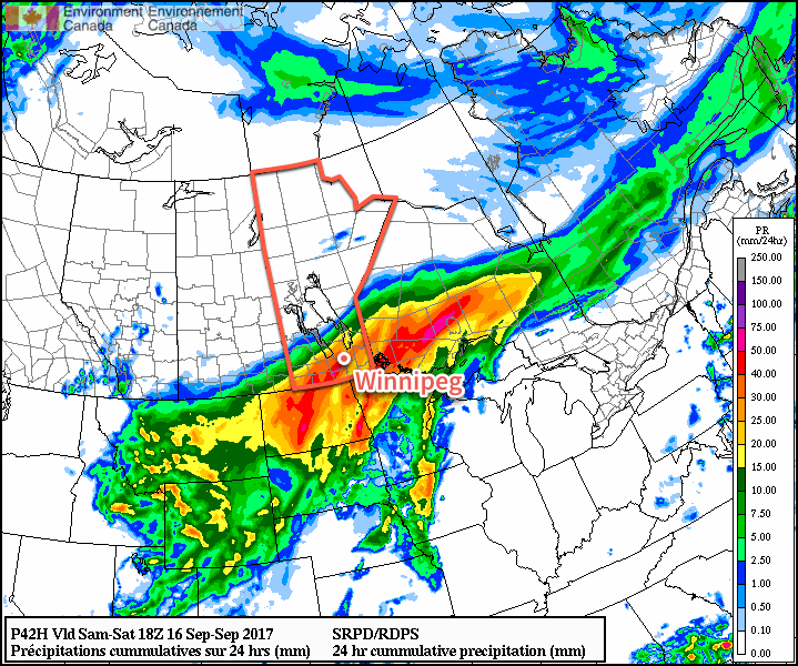
As mentioned on Wednesday, a low pressure system will begin working its way into Manitoba today, bringing what will likely be the largest rainfall event of 2017 [thus far] to the city. The biggest change between our forecast on Wednesday and what is expected to happen today is the timing: the system’s arrival will be slightly delayed, beginning in the afternoon rather than the morning.
So, today will start off fairly cloudy skies, although a few sunny breaks are possible between now and this afternoon. As the low pressure system lifts northwards out of Nebraska into the Dakotas, cloud will thicken up over the Red River Valley with rain beginning this afternoon. The rain will become more intense into the evening with even a small chance for a crack of thunder or two. The heaviest rain should move out around midnight, with some showers or drizzle left behind.
Temperatures will be cool; expect a high near 14°C, but quickly drop to around 10 or 11°C when the rain begins. Expect a low near 8°C tonight. The winds will also be rather unpleasant, picking up out of the north-northeast to around 40-50 km/h this afternoon. The winds will persist into the evening, then diminish to 30 gusting 50 km/h overnight.
By the time the bulk of the rain pulls out of the region, Winnipeg and the Red River Valley will likely see between 20 and 40 mm, with the potential for a bit more or a bit less locally depending where exactly any heavier or lighter bands of rain set up.

Saturday will bring very cool weather to the Red River Valley with daytime highs likely not even reaching 10°C. Stuck between the Friday night’s disturbance and another one that will move through Saturday evening, skies will remain cloudy with a continued chance of showers or drizzle. Winds will continue out of the north-northeast at 30 gusting 50 km/h for the day, but then diminish to calm in the evening.
As the next disturbance rolls by on Saturday evening, it will likely produce another batch of showers or rain over the Red River Valley, but amounts will be considerably less, with under 5 mm expected for most of the Red River Valley. Temperatures will drop to a low near 7°C.
And for Sunday, some morning cloud with the potential for showers or drizzle will begin moving out midday, bringing mixed to sunny skies back to Winnipeg for the afternoon. Expect a high near 15°C with winds picking up out of the west-southwest to around 30 km/h.
Long Range
The beginning of next week will start off sunny with temperatures returning to near-seasonal values for Monday and Tuesday. By Wednesday, however, another series of disturbances roll through the region, bringing what looks like another fairly good chance for more rain through the latter half of the week.
Winnipeg’s seasonal daytime high is currently 18°C while the seasonal overnight low is 6.
