August was an interesting month regarding temperatures, particularly because the overall trend was shaped largely by the distinct lack of humidity. The monthly mean temperature ended up slightly below seasonal, but that was driven by unseasonably cool overnight lows. In fact, the average overnight low for August 2017 was 2°C below the seasonal average. Contrast that with daytime highs that were actually warmer than normal; August 2017 ended with an average high slightly above the seasonal average.
Perhaps of note, humidity levels were quite low through the month of August. We don’t quite have the dew point climatology set up here at A Weather Moment, so I asked Winnipeg’s resident weather statistician how August 2017 ranked in terms of average dew point:
Average hourly dewpoint was 11.4°C in August, 16th lowest since 1953. Normal is 12.8°C. Is this what you were looking for?
— Julien C (@jjcwpg) September 16, 2017
So August 2017 ended up the 16th least humid of the last 64 years. The reason cooler nights can be linked to the low levels of humidity come from a simple physics lesson many learn in high school: dry air heats up – and conversely cools down – more quickly than water. The drier conditions allowed temperatures to climb high, but also allowed it to cool off more significantly at night.1 As an aside, this is why many humid places have smaller temperature ranges from day to night, while the driest places on earth typically have huge temperature ranges between day and night.
Getting into the actual statistics, August 2017 ended with a mean temperatures of 17.7°C, -0.8°C below the seasonal average of 18.5°C. The average daytime high was 25.5°C, 0.5°C above the seasonal average of 25.0°C. The average overnight low ended up at 9.9°C, -2.0°C below the seasonal average of 11.9°C.
August wraps up Summer 20172, which ended up with a mean temperature of 17.8°C. That places it as the 87th warmest3 on record, and comes in -0.6°C cooler than the summer of 2016.
Rain, What Rain?
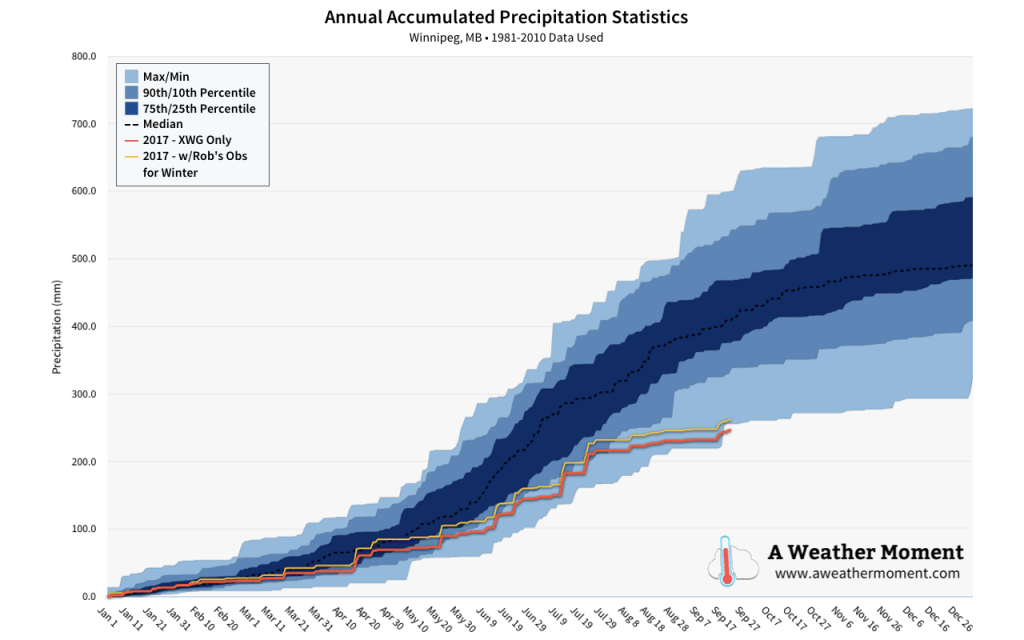
Another notable aspect of August 2017 was the distinct lack of rainfall. Typically Winnipeg will receive around 77 mm of rain through August, but this year the city received only 14.1 mm at the airport, a mere 18% of the normal monthly rainfall.
August was just another month in the story of summer 2017: it was dry. The summer season accumulated 136.7 mm of rain at the airport, which was just 56% of the seasonal normal of 244 mm.

The drier pattern began in May, and then has not relented. While other areas in the Red River Valley are not quite in as dry a spell as Winnipeg, a general trend of dryness has persisted across much of the region.
August 2017 had measurable precipitation on just 6 of 30 days, with the single largest one-day rainfall total of 6.7 mm on Wednesday August 9th.
August 2017 was actually quite a pleasant month in many ways: most days brought a pleasant and dry summer warmth while evenings were cool. The month brought plenty of sunshine with rain being an elusive sight, continuing the dry trend that began in May of this year.
September has been quite a different month so far, with significant warmth in place this month. Winnipeg hit the warmest day of 2017 on September 12th when temperatures climbed to a record-setting high of 34.8°C. Daytime highs and overnight lows have largely been above-normal much of the month. While rain was sparse at the beginning of the month, the latter half has so far shifted into a more unsettled pattern, bringing relatively frequent rainfalls to the region, although Winnipeg has managed to elude much of the activity.
- I also asked Julien to calculate the correlation between humidity levels and highs and lows. Daily low temperatures had an r value of 0.61, showing a much stronger correlation than daytime highs which had an r value of 0.28. ↩
- Meteorological summer runs through June, July, and August. ↩
- …or 59th coldest, depending how you prefer to look at it. ↩
