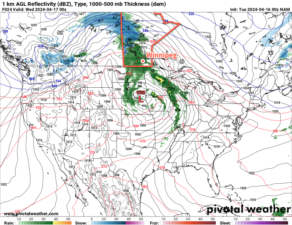
A slow-moving low pressure system will bring wet weather to southern Manitoba as rain showers transition to snow mid-week.

It will be a cool and wet few days in Winnipeg this week as moisture streams northwards out of the United States and brings rain showers to southern Manitoba. This is a large system that spans the Canadian Prairies and into much of the American Plains and mid-west.
The broad view of this system starts with a potent Colorado Low in the United States which is supporting a broad area of rain showers and waves of thunderstorms. This system will stream moisture northwards, where it will then be captured by an upper low over the Prairies and drawn into the northern Prairies.
The result of all this will be waves of rain showers that lift northwards out of the United States into southern Manitoba, pushing towards a feature called a deformation zone that will be aligned north-south along the Saskatchewan/Manitoba border. These are upper-level features that act as walls in the atmosphere; the wind does not move through them, and instead spreads out along them.
As the rain meets this feature, it will spread out into a broad area of rain over western Manitoba. This feature will gradually drift east later today and overnight as colder air slumps into the region. This precipitation will likely become mixed with snow overnight as it drifts east to the Red River Valley.
By Wednesday, it could be rain or snow falling as the band of precipitation slowly crosses the Red River Valley. Much of the precipitation should come to an end in Winnipeg later on Wednesday; by this point, the region will have seen anywhere from 10 to 30 mm of precipitation, with a chance that localized areas see even higher amounts. In Winnipeg, storm total precipitation will likely fall in the 15 to 25 mm range.
Temperatures throughout this period will fall from a high in the low teens today to high single digits on Wednesday. A cold front will sweep through on Wednesday night, drawing wrap-around snow into southern Manitoba and bringing even colder air into the region.
Daytime highs on Thursday will struggle into the low single digits with bands of wrap-around snow moving through the region. It will be a windy, cool day that comes as an unpleasant turnaround from the beautiful weather on the weekend.
A Note On Confidence
This system is large and complex, and even at this point there is notable uncertainty with how it will develop; in particular, the complex interactions of the Colorado Low and the thunderstorm activity it triggers in the United States could have knock-on effects that impact the weather here. The evolution of the moisture supply, the positioning of low-level jets, how the deformation zone evolves…these all could notably impact the when, where, and how much of these forecasts.
I’ve shared by best effort at a forecast here with full knowledge that I might think “I should have made a different decision in my forecast” by this evening. This should give you a good idea of the general weather pattern over the next few days, but I recommend keeping up to date on the latest forecasts for your area over on the MSC’s weather forecasts page.
Long Range Outlook
This system will finally start moving out of the region on Friday, leaving behind sunny skies for the weekend. Daytime highs will climb back into the low teens over the weekend, leading into a pleasant start to next week with near-seasonal temperatures and plenty of sunshine.
Today’s seasonal daytime high in Winnipeg is 11 °C while the seasonal overnight low is -2 °C.
