Weather Forecasts, Facts and News for Winnipeg & Southern Manitoba
Author: Brad
Brad lives in Winnipeg with his wife and two children and is the founder of A Weather Moment. He has loved weather from a very young age and has followed that passion through his life so far. He received a B.Sc. in Earth Sciences with Specialization in Atmospheric Sciences and is currently employed in the field of meteorology. You can find the author as WeatherInThePeg on Mastodon.
A clipper system tracking through Southern Manitoba today will bring near-normal temperatures and a very slight chance of a flurry through the early afternoon. Once the system passes through, we’re going to settle into a fairly stable pattern as a dome of cold air settles over Hudson Bay, keeping us in a benign but cool pattern for the remainder of the week.
Wednesday
-11°C / -25°C
Cloudy; a marginal chance of midday flurries. Clearing later in the day.
Thursday
-20°C / -25°C
Mainly sunny.
Friday
-18°C / -22°C
A few clouds.
Today will bring relatively mild weather as temperatures climb up to -11°C or so thanks to a weak clipper system tracking through Central Manitoba that is dragging some warmer air with it as it pushes through. We’ll see mainly cloudy conditions through the morning and early afternoon with clouds then clearing out late in the afternoon or early this evening. There’s a very slight chance of a flurry or two starting midday and through the early afternoon, but the risk is very slight at that. Any organized snowfall should remain to our north and to our east, but even there only around 2cm is expected. By mid-afternoon there will be essentially no threat of snow and the clearing will begin.
This 700mb temperature chart for Saturday evening shows the dome of cold Arctic air set to settle over Hudson Bay.
As the clipper system pushes off into Ontario, cooler air will begin filtering into Manitoba. We’ll see temperatures drop to around -25°C tonight with a modest recovery to around -20°C tomorrow under mainly sunny skies. The temperature will drop to around -25°C once again tomorrow night under clear skies. Friday looks to climb a little bit warmer to around -18°C with some afternoon clouds as a very weak disturbance whips across the province. Slightly warmer air aloft will bump up our overnight low a few degrees to around -22°C or so under clear skies once again.
More of the same (perhaps cooling off a little) is in store for the weekend. No significant snowfall events[1], in Winnipeg or the Red River Valley, are expected right through to the end of next week.
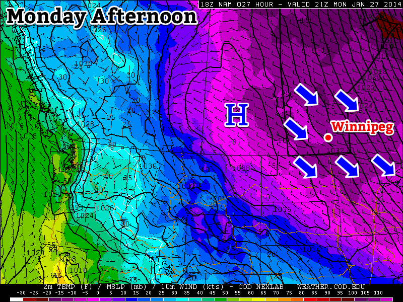
This week will see a return to frigid weather, the likes of which we haven’t seen consistently since early this month.
Monday will be very cold as an arctic air mass remains entrenched over southern Manitoba
Monday
Monday
-25°C / -33°C
Mainly Sunny
Monday will feature extreme cold weather. High temperatures in Southern Manitoba will be in the mid minus twenties, with wind chill values in the upper minus thirties or lower minus forties for much of the day. Temperatures will plunge on Monday night, as will wind chills – don’t forget to plug in your car!
Tuesday
Tuesday
-21°C / -25°C
Mainly Sunny
Wake-up temperatures on Tuesday will be brutal. Air temperatures will be in the low to mid minus thirties, with wind chills making it feel more like the mid minus forties. However, it appears that we will warm up a fair bit during the day on Tuesday. It won’t be warm by any means, but temperatures should climb close to -20C by late afternoon. A southerly flow will develop on Tuesday night, preventing another night of extreme cold.
Wednesday
Wednesday
-11°C / -25°C
Mainly Cloudy. Chance of Flurries.
Wednesday should be the warmest day of the week, as that southerly flow temporarily brings some relief to this cold snap. Daytime highs on Wednesday look to be in the low minus teens, which will make it feel like relatively warm day. Unfortunately, another cold front will blow through Southern Manitoba during the day on Wednesday, bringing a renewed push of arctic air. We may see a bit of snow on Wednesday due to a passing weather system, but amounts will be small.
Long Range
The NAEFS model suggests that we’re in for a prolonged cold snap.
The long range forecast looks really bad. For the first time since the beginning of this month there are strong indications of another prolonged cold snap. Long range models suggest this cold weather will last into the beginning of February for sure, but perhaps longer than that. We’ll just have to hope the models are wrong.
Take heart and treasure the mild weather we have this morning; the Arctic cold front is on it’s way and through a series of low pressure systems we’ll see a snowy couple days drag us back into the icy grip of winter.
Friday
3°C ⇘ -12°C / -25°C
Light snow beginning midday. 2-4cm. Clearing & windy in the afternoon.
Saturday
-17°C / -24°C
Increasing cloud in the afternoon; snow overnight.
Sunday
-19°C / -30°C
Risk of a blizzard. Snow ending midday. Windy.
Mild Weather Forced Out
Our daytime high will not happen this afternoon. In fact, it will be roughly around where we are at the time of this being posted; an expected high temperature of -3°C sits only a couple degrees above where we are at right now and then we’ll see temperatures start going the wrong way behind a cold front set to push through midday.
We may see a few flurries this morning but the more organized precipitation will hold off until midday when a cold front begins working it’s way southwards. Complicating things will be an upper level shortwave that is rippling down in a northwest flow will ride along the frontal boundary and provide additional lift, helping make snow a little more widespread than it would be otherwise. Due to that, most areas across Southern Manitoba will see some snow through midday as everything passes through. Significant amounts are not expected as mid-level moisture will be somewhat lacking and limit the amount of snow that can be produced. In general, around 2-3cm will be seen in many areas. There’s a slight chance we’ll see a little more in the southwest Red River Valley – near Morden, Winkler, Altona & Gretna – thanks to a closer proximity to the upper-level shortwave and a little more mid-level moisture. Even there, though, I don’t expect to see more than 4 or 5cm.
The snow will taper off this afternoon and stronger northerly winds will develop to around 30 gusting 50km/h. Some local blowing snow might develop through the afternoon, but it shouldn’t be a widespread issue. Temperatures will begin tanking as the northerly wind ushers in cooler Arctic air, but fortunately the big cool-off will hold off a couple more days. Temperatures should drop through the afternoon to somewhere between -10 to -15°C by evening and then onwards to an overnight low close to -26°C or so under clear skies and diminishing winds.
A Cool, Calm Day
GDPS 850mb temperature forecast for Saturday showing a strong baroclinic zone through the Prairies.
Saturday will bring fairly benign weather and act as our calm before the storm. A cold, sunny start to the day will go on to see a high around -17°C under increasing cloudiness as a compact but powerful system zips towards the province along a strong baroclinic zone. A few flurries are possible anywhere there’s cloud, but the organized snow will push into Western Manitoba midday and work it’s way towards the Red River Valley by evening. Around 5cm will fall over Western Manitoba while just 2-4cm are expected here in the valley with the potential for some higher amounts along the western escarpment thanks to an upslope flow that will develop overnight.
Winds will remain fairly light throughout the day and night. Flurries will persist until Sunday morning and we’ll drop to an overnight low of around -24°C.
Miserable Weather for Sunday
The NAM (among others) is forecasting a strong pressure gradient over Southern Manitoba on Sunday.
The big story behind the departing low pressure system on Sunday will be the absolutely massive Arctic ridge racing into the Prairies behind it. A very strong pressure gradient is set to develop over Southern Manitoba which will produce strong winds. At this point, it looks like winds will steadily increase early Sunday morning to 40 gusting 60km/h in most places. Through the southern Red River Valley winds will likely climb into the 50-60km/h range thanks to the funnelling effect of the terrain.
Anyone with highway travel plans for Sunday should keep updated on the weather conditions and be prepared for potentially hazardous weather conditions with near-zero visibility on highways.
These strong winds, combined with instability in the low-levels thanks to more cold air pushing southwards and the fresh snow of the past couple days will very likely produce widespread blowing snow. It does look like a blizzard may be possible, although things may end up being a little too marginal. For a blizzard on the Prairies, Environment Canada requires:
Winds of at least 40km/h or greater.
Visibilities of 1/4SM (400m) or less in blowing snow or blowing snow with falling snow.
Both (1) and (2) lasting for 4 hours or more.
The best chance for blizzard conditions will be south of Winnipeg in the Red River Valley and southwards into North Dakota. A strong pressure gradient coupled with ample fresh snow and the funnelling effect of the valley will likely make it quite easy to go down to near-zero visibility. For most other regions, a blowing snow warning seems very possible[1]. Either way, highway travel will likely be poor-to-closed on Sunday. We’ll keep an eye on this as it develops and provide updates a little later this weekend on how things look to be shaping up for Sunday.
Other than the winds, we’ll see skies clear out through the day and our temperature remain steady from Saturday’s low or dropping slightly. The winds will taper off in the late afternoon and we’ll head to a low near -30°C.
Blizzard Update
Right now it looks like this may be the most significant ground blizzard of the winter so far.
Everything seems to be fairly lined up for a significant blizzard event to develop overnight tonight. Winds will begin to pick up through SW Manitoba late overnight and slowly spread eastwards towards the Red River Valley by midday. At this point, it seems like widespread winds of 40-50km/h are possible, although it is possible the winds strengthen as high as 50-60km/h in some areas. Gusts to 70-80km/h are quite likely throughout much of Southern Manitoba.
Widespread blowing snow is expected on Sunday. Maximum blizzard potential exists through SW Manitoba, the western Red River Valley and southwards into North Dakota.
These strong winds will work in tandem with fairly deep low-level instability and a surprising amount of moisture to make very favourable conditions for blowing snow. The strong winds will persist for at least 6-9 hours in most places, making a long-term blowing snow or blizzard event quite likely. If you have any plans to travel on highways in Southwest Manitoba or the Red River Valley on Sunday, it is best to give yourself ample time & make alternate arrangements; white-out conditions are very likely and some highways may be closed. Right now it looks like this may be the most significant ground blizzard of the winter so far.
This blizzard event will extend all the way southwards into North Dakota where there is absolutely no question that a significant ground blizzard will be underway. Just to repeat, conditions will get worse as one travels south. Winds will begin to ease and let conditions improve from north to south through the evening hours.
All in all it will be a lousy day for highway travel. Don’t do it if you don’t have to and stay safe.
Like a blizzard warning, but only requires 1/2SM visibility (800m) and 3 hour duration. ↩
The latest shot of Arctic air is set to be ushered out thanks to an extremely powerful storm north of 60 that will flood the Prairies with mild Pacific air and push our temperatures well above normal by week’s end. The big questions is: will it stick around?
Wednesday
⇓ -27°C / -32°C
Mainly sunny, windy and cold.
Thursday
-10°C / ⇑ -7°C
Increasing cloud with a chance of flurries overnight. Warming.
Friday
-2°C / -17°C
Cloudy and warm. Chance of flurries.
Bitter Cold in Mid-Week Slump
We’ll see bitterly cold temperatures before our big warm-up as yet another very strong Arctic ridge slumps through the province. We’ll see fairly strong winds at around 30km/h gusting to 50km/h out of the northwest this morning and little-to-no recovery from our overnight low today as temperatures struggle to climb before falling to about -27°C this afternoon thanks to the cold air mass that’s pushing in. Blowing snow may remain an issue through the morning hours until the wind begins to taper off. Some cloud cover will linger in the region, but overall it should be a mainly sunny day as it often is when we have these very cold air masses incoming.
Temperatures will drop off to around -32°C or so tonight under clear skies with fairly light winds. Wind chill values will dip to the -37 to -40 range, but it doesn’t look like the criteria for a wind chill warning[1] will be met so I don’t expect any warnings to be issued for Winnipeg.
This forecast tephigram from the NAM shows the sharp low-level inversion in place late Thursday that will likely help produce strong winds.
Thursday will be our transition day, much like (but not quite as strong as) last Wednesday[2], with temperatures warming to around -10°C by day’s end. With such warm air relative to the very cold air that will be entrenched in the valley, a strong inversion will develop which will aid in producing fairly strong winds. They will strengthen as we begin to warm up in the late morning into the afternoon to around 40-50km/h out of the south/southwest. The wind will conspire to make it feel quite a bit cooler than our advertised high would imply, and we may also see localized blowing snow through the valley which could make travel on some roads a little more difficult. A widespread blowing snow event is not expected.
Clouds will roll in through the afternoon as we begin to fall into the influence of the massive storm rolling through the Arctic. There will be a chance of some flurries overnight as our temperature continues to rise to around -7°C although most of the snow activity should stay to our east.
Mild Friday To End Week
Friday will start off on a great foot with temperatures quickly climbing towards -2°C with mixed skies and southwesterly winds at around 30km/h. A weak cold front will push through the Red River Valley midday which will cool off our temperatures slightly, but the bigger impact will the the potential for some snow as the front passes through and then stronger northerly winds in behind it strengthening possibly up to 40km/h with gusts to 50-60km/h. This strong northerly wind will tap into cooler air to our north and dip our temperature from our daytime high of -2°C to around -8 or -9°C by the early evening.
Friday night will bring clear skies as we dip towards -17°C for our overnight low.
Uncertain Weekend Ahead
This 850mb temperature forecast from the GDPS clearly shows the strong baroclinic zone bisecting the Prairies (highlighted).
The weekend is a bit of a wildcard at this point…for the most part. The one thing that’s certain is that we’ll plunge back into the deep freeze by the end of it. After Friday’s cold front, there will be a lull in the progress of the Arctic air as the entire atmosphere pivots with the next shot of cold air pushing in from the high Arctic. As the atmosphere takes this pause, a strong baroclinic zone[3] will develop and align NW/SE through the Prairies. There will be light snow along most of the baroclinic zone as it ripples back and forth with weak impulses, but it’s futile to attempt to pin down exactly where it will lie; models tend to have a lot of difficulty in correctly placing these features.
It does seem like the feature will set up further to our west than the last one and we’ll likely remain east of any snowfall. A disturbance will ripple down the baroclinic zone on Sunday which may bring us some light snow and will usher in the bitterly cold air in behind it.
a. Wind chill values of -40 or lower.
b. Winds greater or equal to 15km/h.
c. Conditions (a) and (b) both being concurrently met for 3 consecutive hours or longer. ↩
…where the temperature rose from -27.1°C in the morning to 3.3°C in the afternoon; a whopping 27.4°C (January 15, 2014). ↩