Mild, Snowy Christmas Eve Gives Way to Another Cold Snap

This week will see cold weather continue — not exactly the Christmas present that many were hoping for.
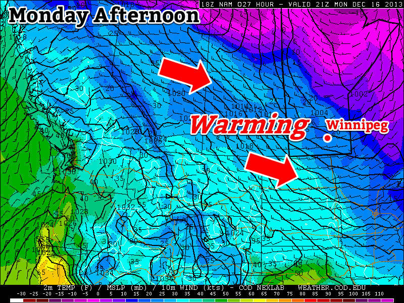
The Wind Will Pick Up on Monday Night

The Wind Will Pick Up on Monday Night

Monday

Monday

Sunny
-23°C / -25°C

After a frigid morning, temperatures won’t recover a whole lot today, but at least it will be sunny! Afternoon temperatures will be in the low to mid minus twenties, with increasing winds. Wind speeds during the morning and afternoon won’t be particularly high, but winds will increase through the evening and into the overnight period. Some blowing and drifting snow is likely in open areas on Monday night as winds increase to 30-40km/h gusting to 50-60km/h out of the south. To add insult to injury, snow is expected on Monday night into Tuesday. The snow will begin in Western Manitoba on Monday night, and push into the rest of Southern Manitoba by Tuesday morning.
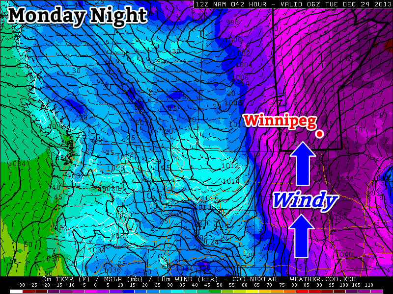
Christmas Eve

Tuesday

Mainly cloudy. Snow.
-12°C / -20°C

Tuesday will be warmer than Monday as those stiff southerly winds overnight bring in some milder air, but this reprieve from the cold will be accompanied by snow. A total of 4-8cm of snow is expected in Southern Manitoba by the time the snow ends on Tuesday afternoon. Temperatures on Tuesday morning will be in the minus twenties, but by afternoon we should climb into the minus single digits over Western Manitoba and the mid minus teens over Eastern Manitoba. The Red River Valley will likely remain stuck in a southerly flow through the day, causing temperatures to remain a bit below -10C.

Christmas Day

Wednesday

Mainly cloudy. Chance of flurries.
-18°C / -28°C

Another cold front will pass through Southern Manitoba on Christmas morning, allowing cold weather to return for the big day. The wind will also pick up behind this front, generating chilly wind chill values. High temperatures for Christmas will be in the upper minus teens, with a chance of flurries through the day.

Long Range

The long range forecast looks cold, cold, cold. We may see one warmer day towards the end of the week, but other than that there is no moderation in the forecast.

$("").attr({
    "rel": "stylesheet",
    "href": "http://fonts.googleapis.com/css?family=Mountains+of+Christmas:700"
}).appendTo("head");
$("h1, h2, h3, h4, h5").css("font-family", "Mountains of Christmas");

Cold Weekend Ahead

Cold temperatures will dominate as Arctic air once again finds itself entrenched over Southern Manitoba. Snow will make an early weekend appearance as a weak disturbance pushes across the province on Saturday, but it won’t be a significant weather-maker.

Friday

-17°C / -24°C
A Mix of Sun and Clouds
Saturday

-20°C / -26°C
Mostly cloudy; scattered flurries likely.
Sunday

-20°C / -24°C
A few clouds.

Temperatures are going to remain fairly steady through the next few days with daytime highs near –20°C and overnight lows dipping to around –25°C. Today we’ll see a mix of sun and cloud as the next disturbance set to track through our region begins taking shape over the western Prairies. Skies will cloud over completely overnight with a chance of flurries.

The light grey shading depicts areas across Southern Manitoba that will likely see some light flurries on Saturday
The light grey shading depicts areas across Southern Manitoba that will likely see some light flurries on Saturday.

Saturday will bring mostly cloudy skies although a few sunny breaks are possible. Scattered flurries are fairly likely throughout most areas along and south of the Trans-Canada Highway in Southern Manitoba. At this point it seems like accumulations will be practically non-existent; there’s a slight place some places may see a cm so, but a significant snow-maker this system is not. The light snow will taper off in the evening as the system moves off and the clouds begin to break up.

Behind this system we’ll see another Arctic high push into Southern Manitoba. This will clear out the cloud, but once again bring cold temperatures with a high of only –21 or –20°C. The mercury will drop to –25°C or so overnight. There may be a very slight chance we may see some flurries thanks to another system passing to our southwest, but at this point I have a feeling that “cold air is king” and it will be restricted to southwest Manitoba. Keep it in mind, but even if it did happen, it would once again be just a few non-accumulating light flurries.

Looking Towards Christmas

Next week will start off with some slightly milder temperatures as a powerful low pressure moving along north of 60 drags warmer air eastwards across the Prairies with it. At this point it looks like we’ll see warmest temperatures on Christmas Eve with snow moving in through the day and a snow Christmas Eve night. Christmas Day is looking like a snowy start will give way to clear skies and cold temperatures. We’ll have the full forecast for the holidays on Monday!

Alberta Clipper Brings Back the Deep Freeze

After enjoying a well above-normal –2°C daytime high on Monday, things are set to plunge back into the deep freeze as an Alberta Clipper low pressure system tracks into Ontario and allows a new supply of very cold Arctic air to surge southwards across the Prairies.

The Clipper

Wednesday

-9°C / -26°C
Mostly cloudy; flurries likely. Windy.

A potent Alberta Clipper will move through Manitoba today with the bulk of it’s snow falling along a line from Flin Flon through Norway House and Beren’s River where anywhere from 4–10cm can be expected. Further south, we’ll see light snow through the Parkland and Interlake through much of the day, but the snow won’t start in earnest until the afternoon along and south of the Trans-Canada Highway when the cold front associated with this system moves through.

And what a cold front it is! Yesterday saw genuine flash-freezes in the high plains of the Rockies; Dawson Creek, BC had it’s temperature fall from +5°C to –16°C in just 3 hours. In Grand Prairie, AB temperatures plummeted similarly, with temperatures falling from +5°C to –15°C in just 3 hours as well. It’s this intense blast of arctic air which will help this system produce snow despite the fact it is lacking considerable moisture.

While temperatures won’t be set to plummet quite so dramatically further east in Manitoba, we’ll certainly see the cold air return with a blast. We’ll be dealing with snow, wind, blowing snow and bitterly cold temperatures/wind chill by the end of the day today. Here’s what you can expect:

Snow: We’ll likely see scattered light flurries through the morning and early afternoon. Marginally more organized snow will try to push in through the afternoon along the cold front, but the system will have difficulty producing much snowfall anywhere other than along the northern edge of the track of the low pressure system. By the time things taper off this evening, anywhere from just a trace of snow to 2–3cm will likely have fallen in Winnipeg & the Red River Valley.

Wind & Blowing Snow: Winds will remain fairly light through the day until the passage of the cold front early this afternoon. Behind the front the winds will flip to the northwest and pick up strength to 30–40km/h with gusts as high as 60km/h. This wind will couple with the loose snow on the ground and the falling snow to produce widespread blowing snow through much of the Red River Valley. The worst areas for blowing snow will be the western and central RRV on any west-east running roads, including the Trans-Canada Highway between Winnipeg & Portage la Prairie. If you have plans to travel west on the Trans-Canada Highway today, be prepared for slippery roads with snow and blowing snow producing very poor visibilities.

Falling Temperatures/Wind Chill: Temperatures will fall quite aggressively behind the cold front with temperatures dropping from our daytime high of around –9°C to an overnight low of around –26°C. The cold temperatures coupled with the wind will produce wind chill values near –35 through the overnight hours.

The Remainder of the Week

Thursday

-21°C / -28°C
Sunny & cold.

The remainder of the week through the beginning of next week will be marked by the presence of yet another significant Arctic air mass entrenched over the Prairies. We’ll see mainly sunny skies on Thursday with light winds but temperatures will be very cold. Our high will only climb to around –22 or –21°C before plummeting back down to –28 or –29°C for our overnight low on Thursday night.

Friday

-17°C / -25°C
Some afternoon cloud.

Temperatures will climb a little higher on Friday as a very weak disturbance ripples down the northwest flow, spilling a little bit of cloud across Southern Manitoba by the afternoon hours. The temperature will climb up to around –17°C and we’ll see the temperature drop to around –25°C on Friday night.

Things look clear and cold for the weekend. Another shot of Arctic air will push into the Red River Valley bringing another batch of bitterly cold temperatures and overnight lows near –30°C.

A Brief Reprieve From the Deep Freeze

After a record cold morning on Sunday, we’ll see a dramatic warm-up to start the week.

Temperatures Will be Warming Up on Monday

Temperatures Will be Warming Up on Monday

Monday

Monday

Chance of Flurries in the Morning, then Clearing
-5°C / -14°C

Today will be the warmest day of the week with temperatures climbing into the minus single digits. There may be a few flurries in the morning, before skies clear later in the day. It will be a windy day too, as westerly winds help to bring in that warmer air. Winds will be 20-30km/h gusting to 40-50km/h.

Tuesday

Tuesday

Mainly Sunny
-13°C / -15°C

Temperatures will cool down a bit for Tuesday, with highs in the low minus teens. It will not be as windy as Monday though, so conditions will remain fairly pleasant.

Wednesday

Wednesday

Mainly cloudy. Chance of flurries.
-8°C / -24°C

A low pressure system is expected to pass through Manitoba on Wednesday, signalling the beginning of the end of this little warm spell. At this point it appears that this system will pass far enough to our north that we won’t see much, if any, snow with it – although that may change. Temperatures on Wednesday look to be around -10C with fairly light winds. A cold front associated with this low will move through Southern Manitoba on Wednesday afternoon and evening, allowing another arctic airmass to surge into the region.

Long Range

Models suggest we will continue to see arctic air dominate our weather until Christmas. There may be the odd break in the deep freeze here and there, but in general there are no lengthly warm-ups currently in our future.