Cooler Weather Pushing In

A cold trough pushing into Manitoba will bring showers today and with cold air building over the province, showers may turn to flurries tonight as temperatures drop. The arrival of cooler air will mark a notable regime change which will leave us in a stagnant pattern with slightly below-normal temperatures.

Friday

7°C / -2°C
Becoming mainly cloudy; showers in the afternoon.
Saturday

5°C / -2°C
A mix of sun and cloud; becoming cloudy in the evening.
Sunday

2°C / -4°C
Mostly cloudy; scattered flurries.

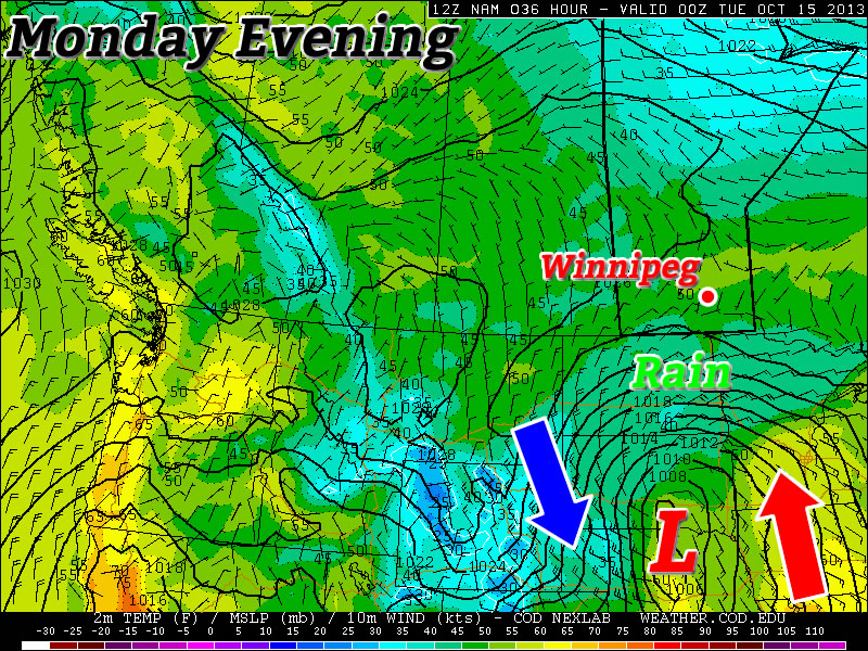
Today will bring increasing cloud this morning which will give way to afternoon showers as a trough slumps through Southern Manitoba. The chance for showers will be very high through Winnipeg & the northern Red River Valley, but through the southern half of the Red River Valley it seems like the showers will be more scattered in nature. Our daytime high of around 7°C will be a couple degrees below our seasonal average of 9°C, and it’s only going to go downhill from there.

Areas that may see lake-effect showers or flurries on Friday night.

Areas that may see lake-effect showers or flurries on Friday night.

We’ll see the showers die off through the evening hours, but it won’t be the end of things; as temperaturs drop in the evening, lake effect showers or flurries will develop in the lee of Lake Winnipeg and Lake Manitoba. Here in Winnipeg it seems like we’ll just see a slight chance of seeing showers or flurries overnight, however to the west and east of the city it looks quite probable.

For the areas that do see precipitation tonight, it may be the first snowfall of the season. While there won’t be much snow and it likely won’t stick, it would not be surprising at all if there were some white flakes falling from the sky tonight. Most areas will see partly cloudy skies tonight save for those underneath the lake-effect cloud and precipitation. Lows will dip to around –2°C with areas under cloud a little bit warmer.

Saturday will be a cool day with a high around 5°C under a mix of sun and cloud. More cloud will push into the Red River Valley late in the afternoon or in the evening as a system diving southwards through Saskatchewan into SW Manitoba spreads some cloud into the Red River Valley. No precipitation is expected at this point for Saturday. Saturday night will be quite cool under partly cloudy skies and lows near –4 or –5°C.

Sunday will bring more cloud into Winnipeg & the Red River Valley as more cool air and instability builds into the Red River Valley. Temperatures will be even cooler than Saturday with highs of only 2–3°C which will make what’s falling out of those clouds more likely to be of the frozen variety than the liquid. Again, not much accumulation is expected, but it may be the first snowfall of the season for many places.

Looking Ahead

We’ll be into a much cooler pattern through the next week with daytime highs sitting near 4 or 5°C through much of the week. It looks like we’ll see a disturbance mid-week bring a chance of showers for most of Southern Manitoba, but nothing in the way of significant (or measurable) accumulations is on the way.

Quiet Weather Ahead

Aside from a couple chances of some scattered showers, fairly seasonal weather lies ahead for the Red River Valley through the second half of the week.

Wednesday

13°C / 2°C
Increasing cloud in the morning. Tiny chance of scattered showers late in the day.
Thursday

9°C / -1°C
A mix of sun and cloud.
Friday

10°C / 0°C
A mix of sun and cloud; chance of afternoon/evening showers.

We’ll see a fairly pleasant day today with temperatures climbing just above seasonal to around 13°C with light winds. Some cloudiness will push in through the day as a cold front pushes towards the Red River Valley. There will be a slight chance of scattered showers along the cold front; any that do develop will be fairly weak and quick-moving. The chance for any one location to see a shower is fairly low, so expect a rather hit or miss pattern if any showers manage to develop along the front. Winds will shift to the NW behind the cold front with partly cloudy skies. Temperatures will drop to around –1°C overnight.

Thursday will be a quiet day with light westerly winds and a high around 9–10°C. We’ll see a mix of sun and cloud and fairly uneventful weather. The overnight low on Thursday night will drop to around –2°C.

On Friday, we’ll see a mix of sun and cloud with a chance of afternoon or evening showers as a second disturbance slumps southwards through the interlake drawing another push of cold air with it. The chance for any precipitation looks significantly better than it does for today, but if we do see shower activity total rainfall amounts anywhere in the Red River Valley only be a couple mm at most. Cooler air will continue to filter southwards through the night with enough instability building to likely produce some lake-effect showers or drizzle in the lee of the lakes. While it will depend very much on the exact wind direction, at this point it looks like Winnipeg may see some of the lake-effect activity since winds are expected to be roughly from the NNW (~ 20°), which would bring cloud and any precipitation from the south basin of Lake Winnipeg into the city. We’ll keep an eye on that as we get closer to the event.

The Weekend Ahead

A fairly benign weekend seems to be in store with little notable weather occurring. Highs look to be slightly cooler than normal in the 7–9°C range with afternoon clouds. No precipitation is expected at this time. Also of note is that now that we’ve passed the Thanksgiving long weekend, frost will no longer be mentioned in Environment Canada forecasts for the Prairies. If you haven’t seen frost yet, consider yourself lucky.

So all in all we have some typical fall weather ahead. Enjoy!

Feeling More Like October

This week will feel more like October as temperatures return to more normal values.

A Colorado Low Will Pass to our South on Monday

Today

Monday

Mainly Cloudy
9°C / 4°C

Another Colorado Low system has made its way onto the American Plains today and just like the last one, it will mainly miss Southern Manitoba. Border regions may see a bit of rain from this system, but in general it won’t be much of a factor in our weather. It will keep skies on the cloudy side though, with mainly cloudy conditions expected in most of Southern Manitoba through the day.

Tuesday and Wednesday

Tuesday

Mainly Sunny
10°C / 0°C
Wednesday

Mainly cloudy. Chance of Showers.
12°C / 2°C

The Colorado Low will have departed the region by Tuesday, leaving behind sunny skies and seasonal temperatures. The wind will be from the north, but it won’t be terribly strong.

Wednesday may see a bit more rain in Southern Manitoba, as a weak system swings down from the north. Temperatures will be in the
low teens, with more cloud than sun.

Long Range

In the long range models suggest that seasonal to below-seasonal weather will dominate. Based on current forecasts, we’ll likely see some light flurry activity before the month is out, but luckily no major snowstorms are currently in the forecast!

Late-Season Thunderstorm Risk Kicks off Dreary Weekend

A powerful low-pressure system pushing northwards out of the Dakotas that will bring copious amounts of rainfall to SE Saskatchewan and Western Manitoba will also bring a risk for thunderstorms, perhaps even an isolated severe thunderstorm, this evening in advance of an occluding cold front. This will mark the start of a somewhat dreary weekend for the Red River Valley that will be marked most notably by a wet & windy Saturday and a very cool, albeit sunny, Sunday.

Thunderstorms Possible Today

Friday

19°C / 12°C
Mainly cloudy. Chance of showers with the risk of a thunderstorm late in the day.

We’ll see a mainly cloudy day today with relatively nice temperatures as we sit in the warm sector of the low pressure system pushing into the province. Despite the cloudy weather, we should see temperatures climb to around 19–20°C for a high with south-easterly winds to around 30km/h.

We may see a shower early this morning as the warm front pushes through and brings us into the warmer air, although a majority of the activity will be off to our west. If anything manages to push into Winnipeg, it will be relatively short-lived. After that we’ll see no chance of precipitation until later in the afternoon or the evening as a cold front begins pushing into the Red River Valley from the south.[1]

Event outlook for Friday, October 11th.

Event outlook for Friday, October 11, 2013.

While we sit under cloudy skies, this would be a good time to note that the weather to our west will be decidedly different. Rain will push in early this morning and spread NNE through the day, hitting areas west of the Red River Valley and Lake Manitoba the hardest. In total, anywhere from 35–75mm of rain is expected, with the lesser amounts closer to the Red River Valley and the higher amounts running along the Saskatchewan border then towards Lake Winnipegosis with enhanced precipitation near the Riding Mountains as upslope enhancement in the north-easterly winds amplifies the amount of rain. Environment Canada has rainfall warnings out for many regions in Western Manitoba, and you can check here to see if your region is covered by one and find additional details.

As the cold front approaches the Red River Valley this evening we’ll see considerable destabilization of the mid-levels coupled with an extremely strong 60–70kt 500mb jet beginning to poke it’s nose north of the border. The Red River Valley will lie in a fairly diffluent area aloft with strong convergence along the cold front as it pushes northwards. Limited surface moisture will constrain SBCAPE values to only a mere 400–500J/kg, but the extremely strong dynamics, in particular the strong directional and speed shear, may help promote the growth of strong-to-severe thunderstorms along/just ahead of the cold front.

This all is highly dependant on either enough destabilization occurring or enough convergence occurring along the cold front. At this point, I think that the southern Red River Valley will see the strongest storms with a lesser risk of strong storms further north here in Winnipeg. By the time the front reaches us, it seems like it will be a band showers and/or thunderstorms with less organization than when things initiate in the Dakotas. If any of the storms do become severe, the main threats will be large hail and strong winds. There will be a very small risk of a few weak tornadoes with these storms, but I believe that will be most likely in North Dakota with the odds diminishing fairly rapidly as you push northwards through the Red River Valley.

The showers/thunderstorms will push through overnight as we drop to a low of around 11 or 12°C.

Wet & Windy Saturday

Saturday

↘ 6°C / 2°C
Cloudy with showers. Windy. Temperature dropping through the day.

Saturday in Winnipeg will be marked by wet and windy weather as we move onto the back-side of the Colorado low and see some wrap-around rain and gusty northwesterly winds move in.

The rain will likely be somewhat showery in nature – in that we won’t see solid rain all day long – and there’s some uncertainty on how much we’ll see exactly, but around 5mm seems like a relatively safe bet at this point. If the system is a little faster than forecast we could end up with almost nothing as the rain would fall further north, and if it’s slower than forecast we could see closer to 10mm as we end up under the wrap-around rain for even longer.

The wind will be the main weather story though. Here in Winnipeg we’ll see winds 30–40km/h out of the northwest with gusts up to 60km/h, but it will be a significantly different story for those on the lakes. Winds over the lakes will increase to nearly 50–60km/h on Saturday with gusts as high as 90km/h, which will produce fairly sizeable waves. If you have a home or cottage on the southern or eastern shores of the lakes, you’ll want to make sure you make any preparations you might have to and prepare for some strong wave action and howling winds for Saturday and Saturday night.

With those strong winds will come falling temperatures; here in Winnipeg we’ll likely see temperatures fall to around 5 or 6°C by the end of the day as colder air pushes in on the back-side of the low. Skies will clear and winds will lighten overnight as we drop to around 2°C for our overnight low.

Sunny but Cool Sunday

Sunday

9°C / -2°C
Sunny. Cool.

Sunday will see the return of the sun, but the price we’ll pay is significantly cooler weather than we’ve been having over the past week. Daytime highs on Sunday will top out at only 9 or 10°C and it will be a slow climb to get there. Temperatures will likely drop well below 0°C on Sunday night with a hard frost likely as temperatures dip to around –2°C.

This will also mark the transition into a cooler pattern. Daytime highs will remain around 10°C through much of the week.


  1. It sounds odd, but this system is essentially sideways with the warm front and cold front both moving from south to north.  ↩