Warmer, but not Warm

Warmer weather will be more common in Southern Manitoba this week, but that’s not to say it will be warm weather. Rather, it will just feel warm relative to the arctic weather we’ve experienced lately.

Alberta Clipper snowfall map on Monday

The Alberta Clipper that will bring snow to Southern Manitoba on Monday

The weather this week will be characterized by a semi-zonal flow aloft. A zonal flow is when the jet stream moves west to east, which tends to give us neither really cold weather nor really warm weather. A series of small disturbances will ride along the jet stream, bringing us a couple chances for snow through the early part of the week.

Monday

Monday
image
Light Snow
-12°C / -17°C

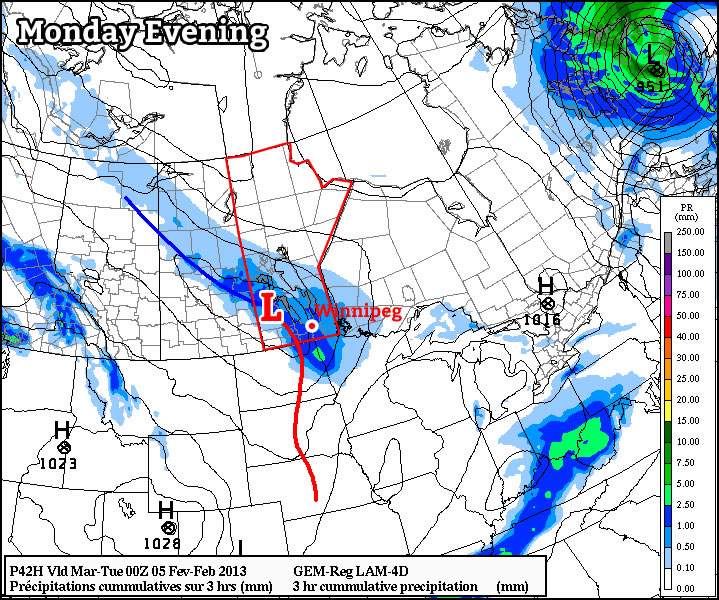
An Alberta Clipper system will roll through Southern Manitoba on Monday bringing more snow along with it. This will be a fairly weak clipper, without much moisture to work with. At this point it looks like the “heaviest” band of snow will pass somewhat south and west of Winnipeg, where up to about 5cm could fall. In Winnipeg and area amounts will in the 2-4cm range. There won’t be much in the way of wind with this system, so its affects will be limited to adding more slippery sections to roadways.

Tuesday

Tuesday
image
Mainly Cloudy
-10°C / -15°C

Tuesday will be a fairly nice day overall, with light winds and mainly cloudy skies. Temperatures will be fairly close to seasonal values, with highs in the upper single digits or lower double digits (below zero of course).

Wednesday

Wednesday
image
Snow
-7°C / -18°C

It appears that we’ll see yet another Alberta Clipper on Wednesday. It will bring snow once again, with accumulations probably being a bit higher than those seen on Monday. It’s hard to say exactly how much we might get from this clipper, but an early guess would be anywhere from 4 to 8cm in Southern Manitoba. Check the comments for an updated forecast for Wednesday over the next couple days.

For once there may be something of interest to talk about in the long-range. There have been numerous indications over the past week that we may be heading toward a more prolonged warm period that could exist through mid-February. The Climate Prediction Centre, NAEFS ensemble, ECMWF, and arctic oscillation predictions are all in line with milder weather for the early to mid-month period. They don’t give a clear indication of how mild it could get, but certainly arctic outbreaks like those experienced in January could be much harder to come over the next while.

The Deep Freeze Gives Way to A Mixed Weekend

While temperatures across the Red River Valley this morning are extremely cold, a developing series of major low pressure systems set to impact Alaska will be responsible for pushing us out of the deep freeze and back towards more seasonal temperatures for next week.

12hr. QPF valid Saturday at Noon

The GEM-REG is showing around 1–2cm of snow across the Red River Valley by midday on Saturday.

Friday


Sunny. Increasing cloud overnight.
-24°C / -28°C

Sunny skies will dominate the Red River Valley for most of the day today as we remain under the influence of the Arctic high. Entrenched in the cold air under this high, temperatures today will climb up to about –24°C; this is some 13°C below the “normal”[1] temperature for this time of year. The strong northwesterly flow aloft that’s brought our cold air back will begin to waver tonight as a weak disturbance ripples down the jet stream towards Southern Manitoba. An Alberta clipper will rush across the Prairies tonight, pushing clouds into Southern Manitoba through the overnight period and preventing our overnight lows from dropping to anywhere near where they bottomed out last night. Overnight lows will likely sit at around –27 or –28°C tonight through most of the Red River Valley.

Saturday

Saturday

About 2cm of light snow.
-16°C / -28°C

As the Alberta clipper pushes through on Saturday, a broad area of light snow will move through the Red River Valley. This system will be rather moisture-starved with only ¼ to ½” of precipitable water to it’s name, so snow will likely be light with SLRs of only around 15:1 (relatively crystalline snow). This will all combine to produce only 1–2cm of snow despite the fact that it will snow most of the day. Temperatures will warm up to around –15°C as a little bit of mild air pushes into the province with this system, but temperatures will plummet right back to where we were before as the clouds clear out fairly quickly on Saturday evening and we head to an overnight low of, again, around –28°C.

Sunday


Mix of sun & cloud. Chance of flurries.
-20°C / -28°C

Skies will start off sunny on Sunday but another weak system tracking across southwestern Manitoba will spread some cloud into the Red River Valley midday. This disturbance will track through fairly quickly so we’ll likely see a chance of flurries (with better chances over southwestern Red River Valley) late in the morning into the early afternoon. The clouds will clear out by evening as we head to another cold night with temperatures dropping back to about –28°C. Heading into next week, the flow aloft begins to become significantly more zonal, allowing milder Pacific air to push further eastwards across the Prairies. Temperatures will generally be warmer but by exactly how much is still hard to tell. Ensemble predictions have moved from an above-normal temperature forecast next week into a more seasonal-looking pattern. Either way, we’ll certainly be leaving the temperatures we’ve seen over the past week behind for a while.


  1. It should probably be said that the “normal” temperature for late January in Winnipeg is most likely just an average of the extremes.  ↩

Back To The Deep Freeze

After a short break from the cold as milder air spilled across the Prairies, significantly colder weather is on it’s way back to the region as a significant Arctic ridge pushes into the Prairies.

850mb Temperatures for Mid-Day Wednesday, January 30th 2013

850mb temperatures show a deep core of cold, Arctic air pushing into Manitoba while near summer-like warmth is in place over the eastern United States.

Wednesday

Wednesday

Mostly cloudy with patchy light snow.
-16°C / -25°C

The Arctic air will slowly push eastwards across Southern Manitoba today which will offset most of our potential warming today and limit our daytime high to only a couple degrees warmer than we dipped down to overnight. We’ll likely see the temperature climb to about –16°C today, but northerly winds of 20–30km/h will make it feel closer to –25 or –26 this afternoon. In addition to the cooler temperatures, some low-level lift associated with the advancing cold air, combined with the mostly cloudy skies in place over the Red River Valley, will result in patchy light snow for most of the day. As things cool off this evening the thermal profile will become less conducive to snow generation which will help any light snow left taper off. Temperatures will drop to around –25°C as skies clear overnight with wind chill values closer to –35.

Thursday & Friday

Sunny skies will dominate through to the weekend as we remain under the influence of the Arctic ridge. Temperatures will return back to the “bitterly cold” range with daytime highs back below the –20°C mark.

Thursday

Sunny.
-22°C / -33°C
Friday

Sunny. Increasing clouds overnight.
-24°C / -30°C

Temperatures will top out at –22°C on Thursday and then plummet to –33°C on Thursday night. Wind chill may be a concern on Thursday night; if winds climb up to even 15km/h wind chill values will drop to –42 to –45 which is below the –40 threshold for wind chill warnings in Southern Manitoba. Temperatures will rebound to only around –24°C on Friday under sunny skies again. Some cloud will push into the Red River Valley on Friday night as an Alberta clipper pushes into southwestern Manitoba; this will help prevent our overnight low from dropping as much as the night before. Currently it looks that the temperature will bottom out at –30°C but it will likely be short-lived as that cloudy, warmer air pushes eastwards.

Cold Weather Set to Return

We’ll see one (or two) more day of nice weather before things turn cold again, another arctic blast is on the way!

image

Manitoba will once again find itself right square in the middle of a major trough this week. This will allow another arctic air mass to surge down into Southern Manitoba by mid-week. This frigid air mass will be ushered in by an arctic front on Tuesday, whose arrival will be announced on Tuesday night with increasing north-westerly winds. However, before that happens we’ll see one final warm day on Monday.

Monday

Monday
image
Mainly cloudy. Risk of freezing rain or ice pellets.
-5°C / -12°C

Monday will be the warmest day this week, with high temperatures in the mid minus single digits in Southern Manitoba. There may be some light and sporadic freezing rain or ice pellets in Southern Manitoba on Monday morning. However, colder air aloft will move in later in the morning, turning any lingering precipitation to snow. The wind will be light on Monday, making it a comfortable day.

Tuesday

Tuesday
image
Mainly cloudy. Chance of flurries.
-10°C / -22°C

On Tuesday we’ll transition from early week’s warm weather to the colder weather that is in store for the rest of the week. As the arctic front approaches we may see a few flurries during the day on Tuesday. However, in general Tuesday looks like an OK day, with temperatures remaining slightly above seasonal and winds remaining fairly light. However, that will change Tuesday night as colder air begins spilling in…

Wednesday

Wednesday
image
Mainly sunny
-22°C / -32°C

We return to the deep freeze on Wednesday, with temperatures more or less flat-lining through the day at the morning’s low temperature. Wind chill values will be very cold as well. Wednesday night will be another frigid one, with temperatures expected to drop down around the -30C mark once again.

Models are somewhat ambiguous in terms of the long-range forecast. There is some indication that we may begin to warm up in early February, but there are other indications to suggest we may remain cold. It’s too early to say what is going to happen, so stay tuned for more updates as we go along.