Another Day of Record Highs, Then…Winter.

Winnipeg has enjoyed 32 consecutive days with above average temperatures, making this one of the more pleasant winters in recent memory. This is about to abruptly change as winter is making an ungraceful return tonight. Before that, however, is another beautiful day with a good chance that more daytime temperature high records will be broken.

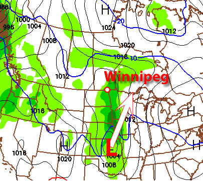
2012-01-10 21Z Surface Prog.

Jan. 10, 2012: 21Z (3PM) surface prognosis from the GEM-REG. Blue line represents cold front, red line represents the warm front.

This afternoon will bring more record-setting temperatures to southern Manitoba as the area is drenched in one last shot of Pacific air. By mid-afternoon, Winnipeg will be firmly in the warm sector, and with 850mb temperatures of 2 or 3°C, temperatures should reach as high as 6 or 7°C through a majority of the RRV, Winnipeg included. There is a slight chance that some areas close to the western escarpment of the RRV could see another day of 9 or 10°C with the extra push from downslope winds and their continued lack of snow cover. That being said, I fully expect daytime high records to be broken in many communities in the RRV today.

Tonight, however, is a whole different story.

Winter Returns

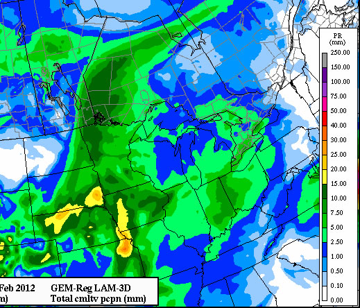
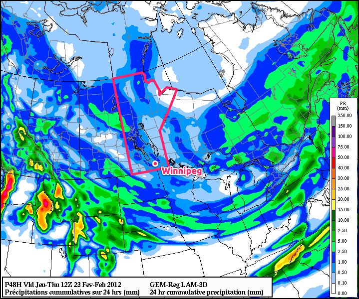
After being held well to our north for over 4 weeks, Arctic air will surge across the Prairies today and tonight, bringing a drastic change to the weather. The cold front will sweep through Winnipeg between 00Z and 03Z (6PM & 9PM, respectively), ushering strong northwest winds and much colder air. Much of the southern Prairies will see snowfall with this system, with areas closer to the international border receiving 2-4cm. Winnipeg will be near the northern fringe of the snowfall, but I think that we’ll see at least 2cm of snow here. I think that 5cm is very unlikely, but there is still some uncertainty in how intense the band of snow will be. The most significant snowfalls will occur through the Northern Interlake, where they’ll be under the influence of a hang-back trough from the main low pressure system, bringing them snow for a longer period of time than us in the southern portions of the province.

2012-01-11 15Z 850 Wind Prog

Jan. 11, 2012: 15Z (9AM) 850 wind prognosis from the NAM

With winds at 850mb forecast to be 30-40kt, surface winds have the potential to gust as high as 70km/h overnight. Likely, we’ll see a period of sustained winds near 50km/h before things settle out with sustained winds near 40km/h with gusts to 60km/h. Combined with temperatures that should fall to near -15°C tomorrow morning, wind chill values will be as low as -25 overnight.

2012-01-12 06Z 850 Temp Prog

Jan. 12, 2012: 06Z (Midnight) 850mb temperature prognosis from the NAM

A second cold front will pass through the RRV between 15Z and 18Z tomorrow morning (9AM and Noon), reinforcing the strong winds and causing temperatures to either remain steady or drop through the afternoon. The gusty northwest winds should continue through the whole day, with some light flurries and temperatures that will start near -15°C and drop to close to -20°C by evening. These temperatures combined with the wind should result in wind chill values near -30 for most of the day.

Normal daytime highs for this time of year are around -13°C and normal overnight lows are around -24°C. For the first time in over a month, Winnipeg will experience below-normal temperatures.

Extremely cold air at 850mb will move over the southern portion of the province Wednesday night; with 850mb temperatures in the -25 to -30°C range, we can expect overnight lows close to -25°C for Wednesday and Thursday night, with a daytime high on Thursday barely above -20°C. The GEM-REG is a little warmer than the NAM on the cold air moving over the RRV, so there is a chance of temperatures being a couple degrees warmer than this, but I’ll always bet on the cold air.

Fortunately, it looks like the cold weather will be relatively short lived. Current indications are that another low tracking across the Prairies should push warmer air into Winnipeg for the weekend, with daytime highs near -5°C. More on that later in the week.


UPDATE: 6 records fell again today across Manitoba as most places enjoyed yet another mild day.
td { text-align: center; }

Location New
Record
Old
Record
Old Record
Year
Fisher Branch 4.9 2.4 2002
Gimli 4.7 3.0 1990
Gretna 7.5 2.6 2006
Melita 4.3 2.5 2002
Pinawa 6.5 3.5 1990
Winnipeg (Tie) 5.1 5.1 1990

Changes Coming To Our Weather Pattern

Our remarkably warm January weather will continue for at least a couple more days before some large-scale changes begin to reshape our weather for the rest of January. The weather for the second half of January will certainly be colder than the first half, but just how much colder?

WRF Model Model Temperature Output for Monday, Jan. 9 at 12pm

WRF Model Temperature Forecast for Monday, Jan. 9 at 12pm

Temperatures will remain very warm to start the week. High temperatures on Monday will likely be in the mid single digits in much of Southern Manitoba. As a result, more temperature records will be threatened. Tuesday will also be unusually warm, but temperatures will be slightly lower, with highs closer to zero. The remainder of the week will be colder, with high temperatures for Wednesday through Friday being near to or slightly above normal (normal high being -13C). There is potential for some snow on Tuesday night into Wednesday with the passage of a low pressure system. Current indications suggest that we’ll see a few centimetres of snow from this system, but that could still change. We will continue to monitor this system and provide updates as we get more information.

Beyond this week the forecast becomes somewhat unclear. Most forecasts suggest that we’ll cool off significantly for the second half of January (see CPC outlook above). However, the extent of the cold weather is quite uncertain. We may have to deal with a so-called “roller-coaster pattern”, where big warm-ups are followed by big cool-downs. These roller-coaster patterns tend to bring a fair bit of snow, along with many days with gusty winds. As we move further into January the details will become clearer.

CPC Outlook for late January 2012

Climate Prediction Center’s Forecast for mid January 2012

Many people are wondering what is causing this spell of remarkably warm weather in Southern Manitoba. The main reason for the really warm weather this past December (and early January) is the Arctic Oscillation. The AO, for short, is a cycle which helps forecasters determine whether cold air will be bottled up in the north, or be allowed to spill down into Central North America. For most of December the AO was strongly positive, meaning that arctic air was kept well to our north. Current modelling suggests that a switch to a negative phase of the AO is likely by mid to late January. Once the AO switches to negative, Southern Manitoba will finally be able to get some real winter weather.


UPDATE: 6 records fell across Manitoba today as most places enjoyed yet another mild day.
td { text-align: center; }

Location New
Record
Old
Record
Old Record
Year
Brandon 4.5 4.4 1986
Gretna 8.0 7.2 1958
Island Lake -0.2 -0.6 2002
Melita 8.6 3.9 2006
Sprague 5.9 5.0 1958
Thompson -3.3 -3.8 1983

All in all, 29 records were broken across the Prairies, with a majority of them happening in Alberta and Saskatchewan. Tomorrow will see another day of above-average temperatures in Southern Manitoba before cooler weather arrives on Wednesday.

Slight Cool Down Before Mild Temperatures Return

26 temperature records were broken across the Southern Prairies yesterday as warm Pacific air flooded the region tied to a low pressure system tracking through central SK/MB. The RRV will see a cooler weekend as colder air is creeping southwards on the backside of this system, however the deep freeze is still a little ways off.

Overnight Snow along a weak trough in NW flow

3hr. QPF from the 12Z Jan 06 GEM-REG valid at 09Z Saturday Jan. 7

An area of snow will slowly push southwards through the RRV today, brining only minor accumulations to the region. The system should clear out by this evening, with the chance of a few light flurries through the night in a weak northwest flow. A ridge of high pressure will then work across Southern Manitoba Saturday & Sunday, brining cooler temperatures to the area with daytime highs in the -10 to -5°C range and overnight lows in the -10 to -15°C range through the region.

By Monday, another low pressure system tracking through the northern Prairies will drag more Pacific air over the Prairies once again pushing temperatures above 0°C. Many areas in Southern Manitoba should see daytime highs Monday near 5°C. Currently, it doesn’t look like temperatures will reach nearly as high as some places did yesterday, but things will become a little clearer closer to the day (naturally). It’s quite likely we’ll more daytime high record temperatures broken on Monday.

850MB temperatures from the GEM-GLB

850mb temperature from the 00Z Jan 6 GEM-GLB valid at 00Z Thurs. Jan 12

After that, it looks like we’ll be seeing a bit of a cold snap. On the back side of the system, a fairly strong push of Arctic air will flood through the Prairies, bringing us our coldest temperatures in a while. It looks reasonable, as temperatures in Oymyakon, RU have dropped below -50°C (-55°C when I checked last night), with daytime highs only around -35°C, which is a good indicator for colder weather pushing over the poles towards the Prairies. We won’t get nearly as cold as they are, but by the middle of next week, daytime highs around -15°C with overnight lows around -25°C are certainly possible, as 850mb temperatures are forecast to dip down to -25 to -30°C over Souther Manitoba . This system looks relatively dry, however we may shift into a pattern that will favour clippers tracking along the international border which may bring long-awaited snow to southern portions of the Prairies and the Northern Plains.

Big Changes in 2012

A Weather Moment is proud to continue serving Winnipeggers and the surrounding communities into 2012. As this site continues to develop a community, we plan to bring several additions to the site to help create the go-to place for your weather needs and curiosities this year. Several improvements and additions are already underway, and I thought I’d just outline some of the new things coming up for the site.

More Content

Writing about the weather can be a feast-or-famine affair. Since I started the blog, I find there are stretches where you could write a lengthy post each day about upcoming weather, followed by 2-3 weeks of…well…nothing. However, what’s the point of coming to a site that doesn’t update for 2 weeks? So with that in mind, we plan on providing more regular content. There are several aspects that will help with this:

  1. The tentative plan is to have a M/W/F posting schedule, with additional posts as needed given various weather setups. Please have patience as over the next month we try to meet that schedule and/or decide on other setups that might work better (e.g Mon/Wed/Sat). We are aiming for 3 posts a week, though.
  2. When there are stretches of no significant weather, we plan on tapping into the original plan of doing more educational posts on how various aspects of the weather work. I’ve been disappointed that I haven’t really followed through on that promise for the blog, and it will be rectified this year!
  3. In order to keep up with all this, I’m privileged to announce that Scott, who previously ran, blogged, and forecasted at steinbachweather.ca will be joining staff as an occasional writer. I have full faith in his analysis and forecasting skills and think he will be an excellent addition to the writing team! Some of you are familiar with him, I’m sure, and he is excited to come on board and be a part of this growing community. So people know, I’ve now added a small label at the bottom of each post so you can see who the author of it is.

Expanded Site

The second main goal I have for 2012 is to being to provide tools on this site that will help facilitate forecasting. Over the past year, I’ve developed several exciting new tools that are unlike anything available on the internet right now. I plan on providing them on A Weather Moment to help the community develop their own forecasts and add to discussions. With the tools I aim to provide by the end of February, three things will be much easier:

  1. Viewing model data
  2. Viewing satellite & other real data
  3. Access to text bulletins such as the FOCN45 Prairie Weather Outlook and the SPC’s Day 1/2/3 Severe Weather Outlooks.

As these tools are added to the site, I hope to enable this community to further their understanding of the weather and to have the skills and tools to make informed weather decisions by yourselves!

WX-Central Mobile

As the person who maintains the mobile version of U of M Weather Central, I plan on doing a significant upgrade to make it the best place to get your weather information while on the go. Expect that to be finished sometime in the second half of this year. If you aren’t using it yet, I highly recommend you check it out (and not just because I made it) at http://tinyurl.com/mobilewx.

Lastly, as this site is always a work in progress, always feel free to get in touch with us by e-mailing any questions or suggestions to aweathermoment@shaw.ca.

The Rest

I’m very excited for the future of this site. With Scott’s help, we want to help build a passionate community of enthusiasts and amateur forecasters by providing the topics, forum and tools.

User Photos: One thing I want to strongly encourage people to send in their photos during significant weather events. The two best ways to do it are to either e-mail them to us or attach them to a comment:

How to attach a photo to a comment

How to attach a photo to a comment.

The last post about the record-breaking temperatures is the most commented on post since this site began! Thanks all for contributing to the conversation! I hope you stick with us and enjoy the ride this site will be going on this year. Won’t be long before we can talk about thunderstorms again!

Design: I am continuing to update the page’s design, to make it better able to support new features in the future and to make it aesthetically pleasing. I’d love feedback on it as I go, and don’t be surprised if you see a new thing here or there when you’re browsing the site. I’ve also done quite a bit of work on the mobile version of the site, so if you’re using an iPhone or iPod, give it a try! I’d love feedback on how it looks on older iDevices (i.e. iPod Touch 1G/2G/3G, iPhone 3G/3GS) as well, if anybody is using them!

And that’s all the site news for now! Back to the weather…