Arctic Grip Finally Loosens in Southern Manitoba

Temperatures will finally ease back towards seasonal values in southern Manitoba, bringing an end to the latest round of bitterly cold temperatures.
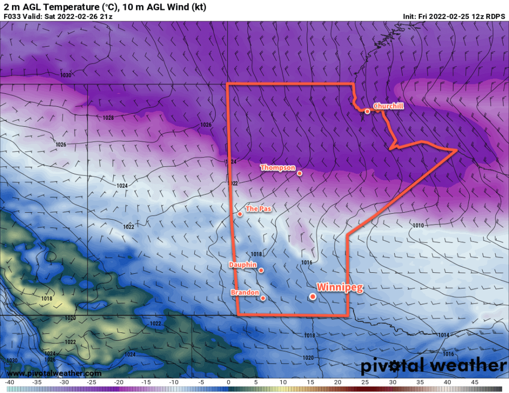
RDPS 2m Temperature Forecast valid 21Z Saturday February 26, 2022
Southern Manitoba will finally see relief from the cold on Saturday with the return of seasonal temperatures.

The relentless cold is finally coming to an end over southern Manitoba today! The lobe of the polar vortex that has entrenched extremely cold temperatures over the region is finally weakening, cutting off the source of the coldest air in the region.

Warmer air will begin to build into the region today, with Winnipeg’s cold morning warming up to a high in the -10 to -15 °C range. Skies should stay mostly sunny through the day with southerly winds picking up into the 30 km/h range. A warm front will push through tonight, bringing a bit more cloud to the region as winds shift to the west. Tonight’s low in the mid-teens will be warmer than the daytime highs of most days this week.

The weekend will bring more cloud to Winnipeg, but a passing low will bring even warmer weather back to the region on Saturday. Highs will reach around -5 °C with cloudier skies and a chance for some light snow as the low passes in the afternoon. A bit of cooler air will filter into the region behind the low, sending temperatures back towards -20 °C on Saturday night and dropping highs into the mid-minus teens for Sunday. Winds will be breezy out of the

Long Range Outlook

Next week will bring seasonably cool conditions to the region with the occasional chance for snow. Daytime highs will likely hover within a couple degrees of -10 °C with overnight lows in the -15 to -20 °C range.

Today’s seasonal daytime high in Winnipeg is -6 °C while the seasonal overnight low is -16 °C.
Bitter Cold Continues Across Southern Manitoba

Winnipeg will stay locked in the grip of a deep freeze as a slow-moving Arctic air mass sits entrenched over the region.

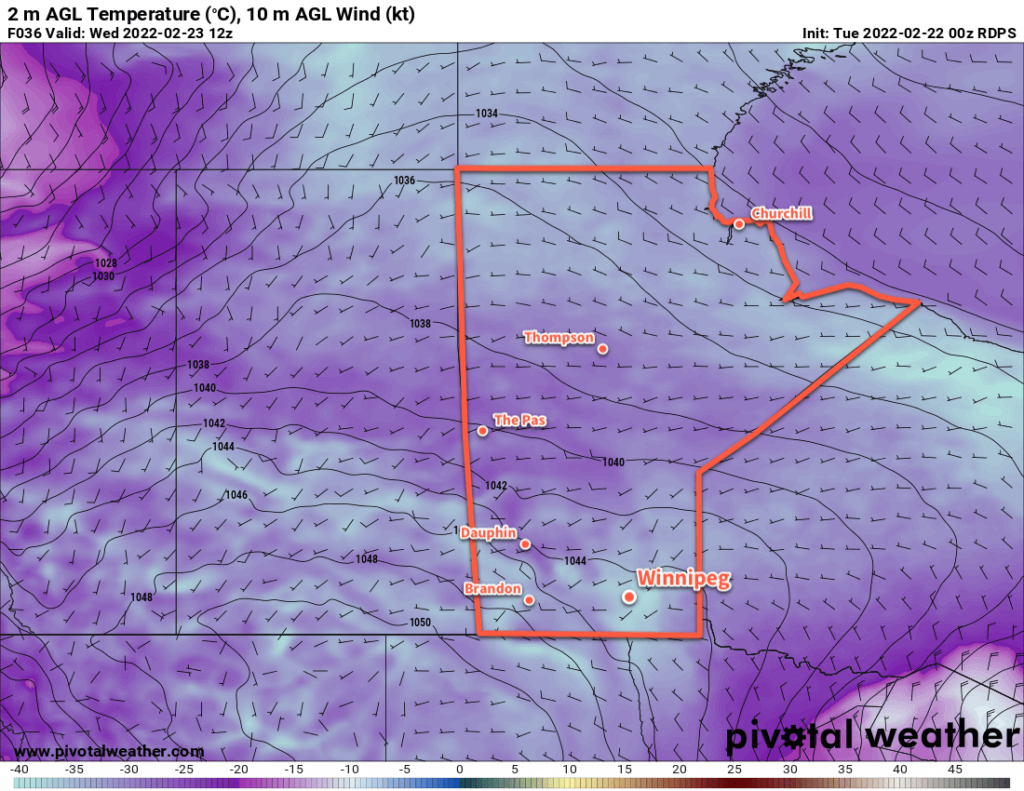
RDPS 2m Temperature Forecast valid 12Z Wednesday February 23, 2022
Very cold temperatures will stay entrenched over Manitoba this week.

Temperatures in Winnipeg will sink over 15 °C below seasonal values this week with highs struggling to reach -20 °C. A bitterly cold Arctic air mass has settled over the region behind the train of storms that brought several waves of snow to the region last week. Unfortunately, this air mass is in no hurry and this week will bring little relief will from the cold.

Skies will continue to be mixed today as the region is grazed by a system moving through the United States. Skies will clear tonight, leaving sunny skies for the rest of the week. Daytime highs will sit below -20 °C through much of the week, only breaking into the mid-minus teens on Friday. Overnight lows will be, editorially speaking, terrible; lows will dip below -30 the next couple nights and climb into the low -20s on Thursday night.

Wind chill will be a notable danger today. Northerly winds of 20–30 km/h continue through the day and produce morning wind chills of -45 to -50 easing to the mid-minus 30s in the afternoon. Wind chills will dip back into the -40 to -50 range tonight.

Long Range Outlook

The Arctic grip will begin to break at the end of the week with highs near the -15 to -10 °C range returning to the region. A system moving through will bring a chance for some snow on Saturday, followed by cooler temperatures on Sunday. All indications are that near-seasonal temperatures will return through the first half of next week.

Today’s seasonal daytime high in Winnipeg is -6 °C while the seasonal overnight low is -17 °C.

Don’t Put The Shovel Away, More Clippers Ahead

Winnipeg will see cool conditions and more snow as clipper after clipper moves through the region.

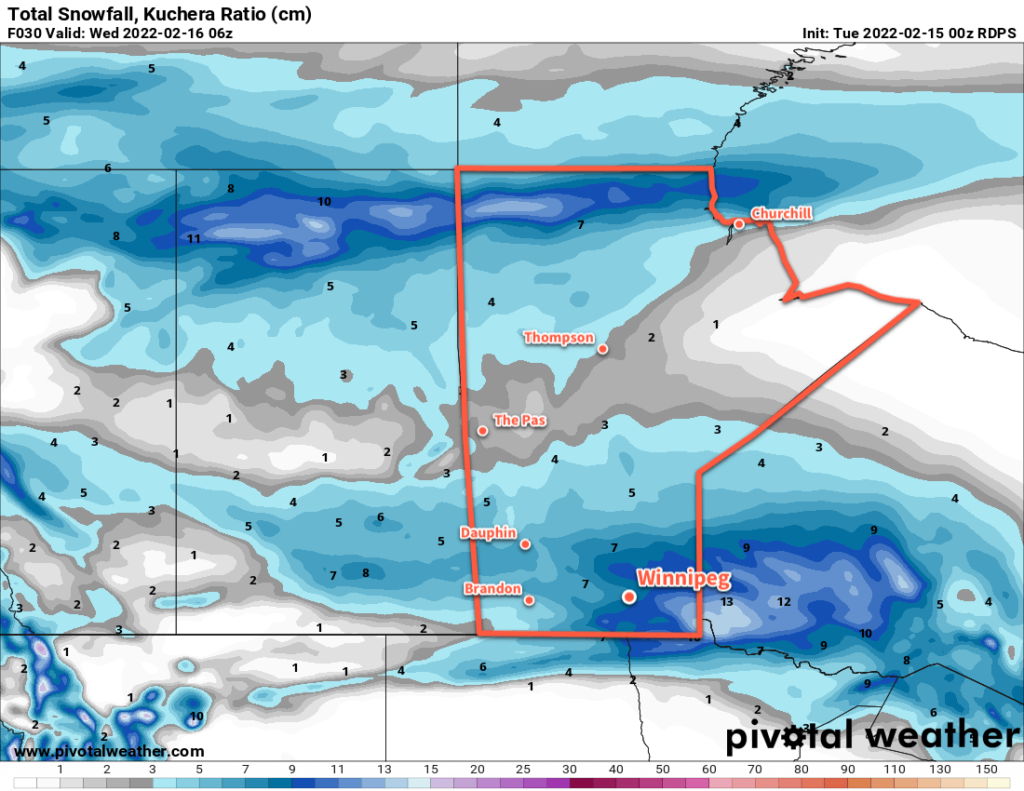
RDPS Total Accumulated Snowfall (Kuchera SLR) valid 06Z Wednesday February 16, 2022
5–10 cm of snow will fall across most of southern Manitoba today.

The snow will gradually pile up this week as multiple disturbances move through southern Manitoba. This train of clippers will keep temperatures generally below seasonal and add to the ever-growing snow banks around the city.

The first clipper will move through the region today, bringing moderate southerly winds, some blowing snow in open areas, and 5–10 cm of new snow by the time it tapers off in the evening. The wind will ease off in the afternoon with a high around -10 °C. Temperatures will head back into the low minus teens tonight with some blowing snow and moderate northwesterlies.

The cloud cover will break up on Wednesday as an Arctic ridge moves into the province. Expect some blowing snow in open areas in the morning, followed by improving conditions as the northwesterlies ease through the afternoon. Temperatures will hover in the -15 to -20 °C range through the day, then quickly drop in the evening with clear skies. Winds will be light on Wednesday night with lows dropping back below -30 °C.

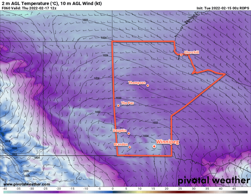
RDPS 2m Temperature Forecast valid 12Z Thursday February 17, 2022
Bitter cold returns to southern Manitoba on Wednesday night with lows bottoming out below -30 °C on Thursday morning.

Thursday will be a sunny, cold day with temperatures topping out in the -20 to -25 °C range. The next clipper to impact the region will start pushing in on Thursday evening, bringing increasing cloud and warming tempreatures. Snow will begin overnight as southerly winds strengthen and temperatures warm into the mid-minus teens. More blowing snow will again develop through the Red River Valley by Friday morning.

Long Range Outlook

Another clipper moving through the region on Friday will bring 5–10 more centimetres of snow to the Red River Valley. There will be little reprieve afterwards, as forecast show yet another low impacting the province on Saturday. This system could end up bringing closer to 10 cm of snow to the region on Saturday into Sunday.

Temperatures will trend on the cooler than seasonal side of things through the weekend and potentially cool a little bit more heading into next week.

Today’s seasonal daytime high in Winnipeg is -8 °C while the seasonal overnight low is -18 °C.

Cooler Weekend Ahead for Southern Manitoba

Winnipeg will see temperatures slide back into the “cold” category this weekend as another Arctic ridge settles into the province.

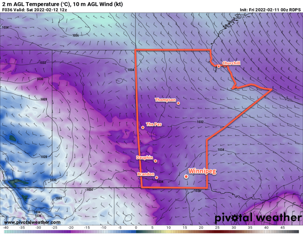
RDPS 2m Temperature Forecast valid 12Z Saturday February 12, 2022
Temperatures will plummet back into the -30s Friday night into Saturday morning.

Today will start out with unpleasant conditions as the region sees blowing snow with moderate northwest winds of 40–50 km/h. The wind will ease through the day with gradual clearing as an Arctic high settles into the region. Temperatures will be notably colder than yesterday with little recovery from the overnight low. Temperatures will hover in the -20 to -25 °C range through the day, then drop below -30 °C tonight under clear skies.

The cold weather will stick around for Saturday, a weak upper trough moving through will likely bring some cloud cover as well. Highs will again sit in the -20 to -25 °C range, and temperatures will head back towards -30 °C tonight.

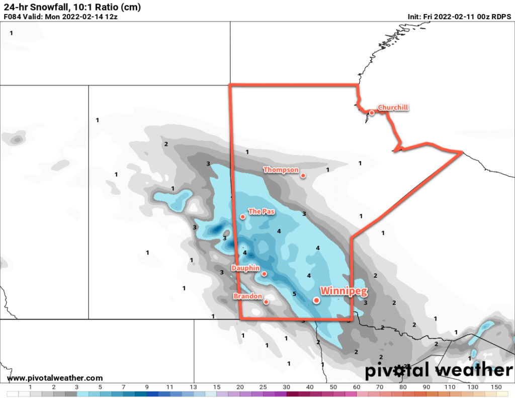
RDPS 24hr. Snow Accumulation valid 12Z Monday February 14, 2022
More snow will move through southern Manitoba on Sunday.

The next low pressure system to impact the region will move through on Sunday. Moderate southerly winds of 40–50 km/h will develop as cloud moves in early in the day, likely producing some areas of blowing snow through the Red River Valley. Snow will move into the region sometime midday, then taper off in the evening.

This system will push the coldest air out of the region, and while it will stay cool into next week, temperatures won’t be as bitterly cold as the region will see this weekend.

Long Range Outlook

Next week will bring varied conditions with some snow possible on Tuesday and towards the end of the week. Otherwise, the region should see sunshine in between with cool highs in the -15 to -20 °C range.

Heading towards next weekend, several forecast show moderating temperatures, with highs returning to seasonal values for the weekend.

Today’s seasonal daytime high in Winnipeg is -9 °C while the seasonal overnight low is -19 °C.