Warm Week Ahead For Winnipeg To Bring A Wintery Mix

Early-season winter warmth will continue in Winnipeg, bringing pleasant conditions along with a mid-week wintery mix.

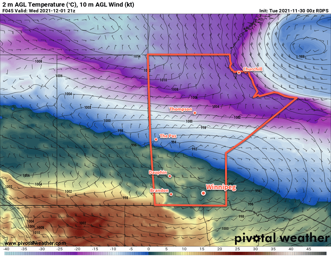
RDPS 2m Temperature Forecast valid 21Z Tuesday November 30, 2021
More early-winter warmth will spread across the southern Prairies this week.

A series of low pressure systems will cross the Prairies this week, spreading more mild air into the region. As a result, Winnipeg will continue to see seasonably warm this week. Daytime highs will sit in the -5 to 0 °C range, but Wednesday will bring temperatures above zero into the low to mid-single digits. Lows will also follow suit, staying several well above the seasonal normals.

The first low pressure system will begin moving into Alberta later today, pushing a warm front eastwards into southern Manitoba. This will spread an area of light snow into western Manitoba this afternoon that will move into the Red River Valley this evening. This system will produce a couple centimetres of snow as it moves through the region.

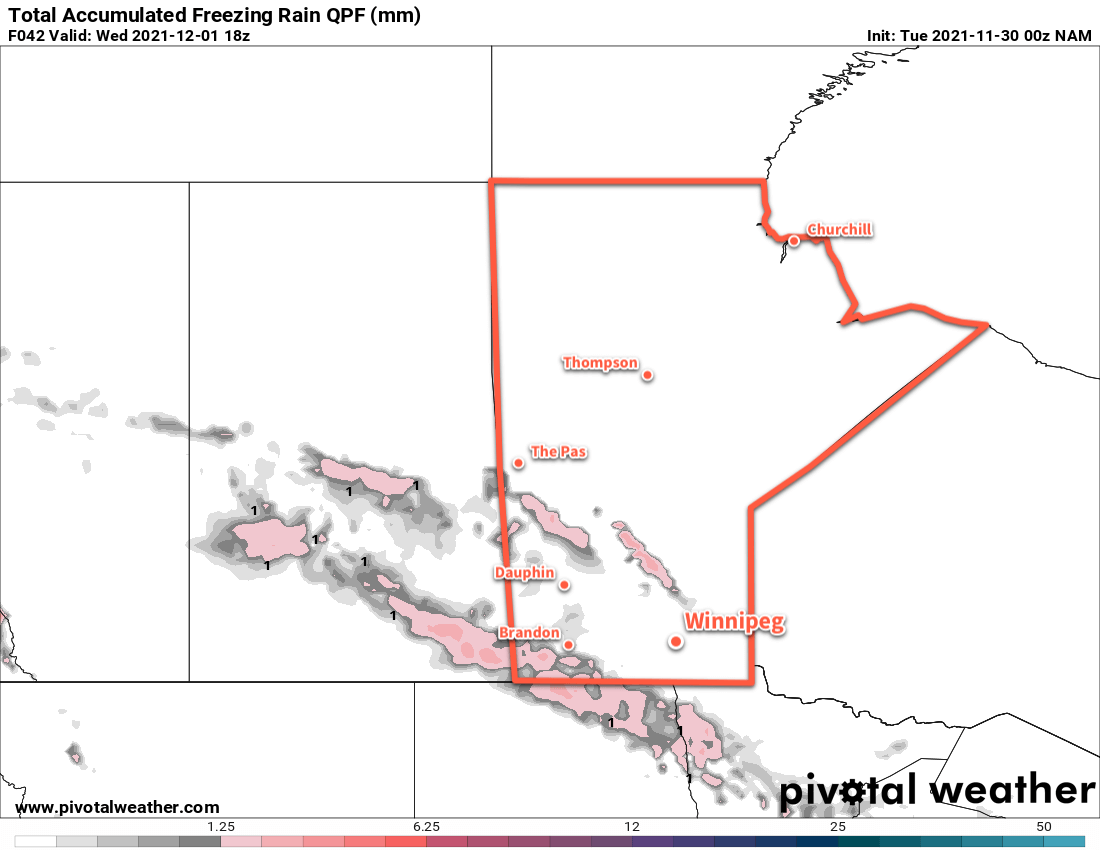
Alongside this, though, will come another risk of freezing rain. The risk will begin Tuesday afternoon in western and southwestern Manitoba. It will then spread into the Red River Valley overnight into Wednesday morning. The greatest threat for ice accumulation is over southwestern Manitoba, but slippery conditions will be possible throughout the risk area.

NAM Total Accumulated Freezing Rain Forecast valid 18Z Wednesday December 1, 2021
Although forecast models are outlining two areas of freezing rain on Tuesday/Wednesday, the risk will extend across much of southern and southwestern Manitoba.

Sunshine will be a relatively rare commodity over the coming week. Today will start off with plenty of sun, but once the cloud arrives later in the day, it’ll stick around through Thursday. A few sunny breaks are possible then, but no widespread clearing trend is likely until the end of the week.

Winds will be variable through the first half of the week, but a cold front passing through the region on Wednesday evening will usher in northwesterly winds near 40 km/h that should ease to light by Thursday morning.

A few more flurries will be possible Thursday night into Friday as another low pressure system crosses the province.

Long Range Outlook

Cooler air will filter into the region this weekend and send daytime highs into the -5 to -10 °C range. This shift in temperatures is forecast to persist into next week with near-seasonal overnight lows. Some more light snow is possible Saturday evening into Sunday, then again on Monday night.

Today’s seasonal daytime high in Winnipeg is -6 °C while the seasonal overnight low is -15 °C.

Shaking Off the Arctic Chill

The Arctic air seen across southern Manitoba on Thursday is already long-gone, replaced by a push of Pacific air that will bring milder weather back to the region.

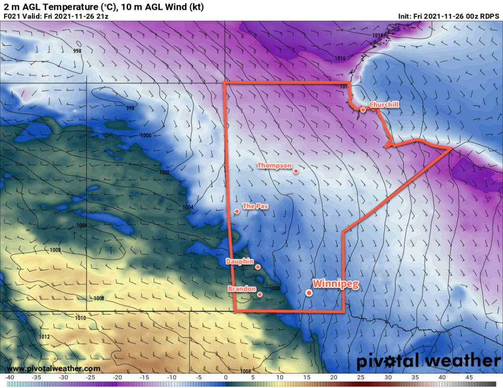
RDPS 2m Temperature Forecast valid 21Z Friday November 26, 2021
Milder temperatures will move into Manitoba today with highs climbing above the freezing mark over the southwest corner of the province.

The cold trough that brought lows in the -20s to southern Manitoba on Thursday morning has already moved well off to the east. Taking its place is a much milder westerly flow that will push Pacific air across the Prairies. This will push highs back up into the [seasonably mild] -5 to 0 °C range across southern Manitoba over the next few days.

Overnight lows will also settle to warmer values, generally in the -5 to -10 °C range.

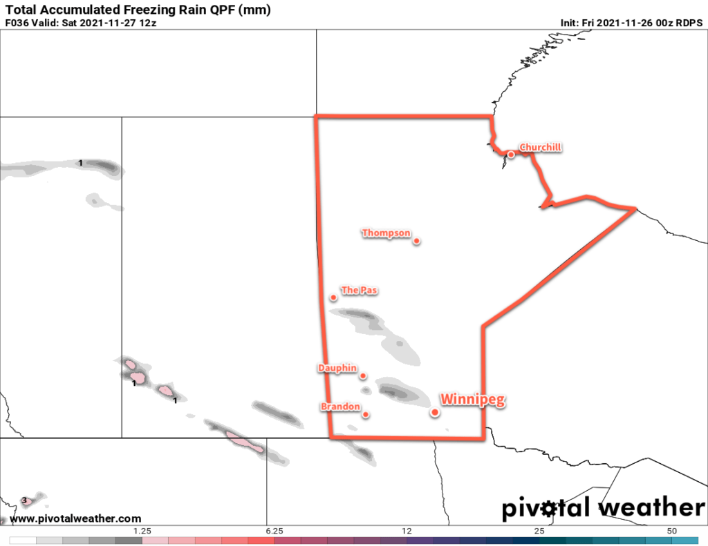
RDPS Total Accumulated Freezing Rain valid 12Z Saturday November 27, 2021
Some patchy light freezing rain is possible across portions of southern Manitoba on Friday night.

The arrival of warmer temperatures will also bring more cloud back into the region. A trough moving across the province will bring cloudy skies later today that will stick around for the night. A few flurries or even some patchy freezing rain is possible across southern Manitoba tonight ahead of a weak cold front that moving southeastwards. Skies will clear out behind the front on Saturday with blustery northwest winds.

A weak Arctic ridge will move into Manitoba on Saturday night, bringing cooler temperatures back to the region. Lows may dip below -10 °C in Winnipeg, but the coldest temperatures will be over western Manitoba. Overnight lows in the -15 to -20 °C range will be possible in that region.

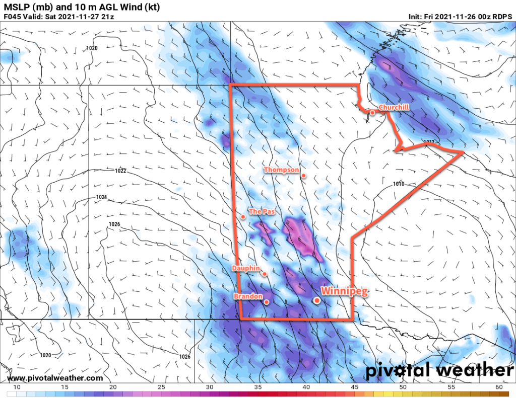
RDPS 10m Wind Forecast valid 21Z Saturday November 27, 2021
Blustery northwest winds will develop over southern Manitoba on Saturday as a weak high builds into the region.

More Pacific air will surge back across the Prairies on Sunday, bringing another push of cloud to the region. A few flurries will be possible Sunday evening as a warm front advances eastwards across southern Mantioba.

Long Range Outlook

Little change to the weather pattern is in store next week. Generally mild conditions will continue with the occasional surge of cooler air bringing brief returns to seasonal temperatures. Southern Manitoba should see sunshine to start the week, but cloudier conditions are forecast for the latter half of the week.

A change in the weather pattern may come at the end of next week. Several weather models show indications of an Alberta Clipper system moving through the eastern Prairies on Friday.

Today’s seasonal daytime high in Winnipeg is -5 °C while the seasonal overnight low is -13 °C.

A Change In Our Forecasts and The Future of A Weather Moment

In 2010, I started A Weather Moment as a small Tumblr blog to share my thoughts on the weather. Up to that point, I had been a frequent commenter on the regionally historic Rob’s Blog and wanted a place to more formally share my thoughts on upcoming weather. That evolved fairly quickly over the following year or two as a more coherent vision emerged: providing a relatively short forecast that helps contextualize what’s going to happen. The team has grown and shrunk over the years, but we’ve been able to, with a consistency I’m rather proud of, post 3 forecasts a week for the better part of a decade.

Things have changed a lot over that decade, though. When AWM started, getting forecasts online was more difficult with limited options, the iPhone 4 had just released, and weather discussion was still a generally niche topic. In the years since, weather has become a big industry. Television shows such as Storm Chasers (which was nearing the end of its run in 2010) helped catapult severe summer weather into the minds of millions of people across North America. Sources for forecasts greatly increased as private sector investment increased, government meteorological services established their online presence, and weather model imagery became more accessible than ever. Smart phones have revolutionized the consumer technology field, and applications such as RadarScope (iOS, Android) have made potentially life-saving RADAR imagery instantly accessible no matter where you are.

All this to say: we don’t feel that our stale Day 3 forecast has a lot of value any more when you can easily see other forecasts updated numerous times in the interim. The details of the weather forecast is now constantly being fed to users 24 hours a day in more accessible forms than ever. That is a major change from when this site started and as one-person operation right now, it’s needed a lot of thought on how to leverage what A Weather Moment can do the best. Contributing to this is also that I was a single person in an apartment when this started, and now there’s a whole lot more life going on with kids growing up; time is limited and valuable!

After a lot of reflection, the time to focus on a few main areas A Weather Moment can really offer something unique and valuable has come. The most significant change will be the way we do forecasts. First, forecasts will now be done twice a week, most likely on Tuesdays and Fridays. They will no longer have specific sky/temperature forecasts for Winnipeg; instead, we’ll be focusing more on the general weather patterns/trends and speaking more generally of what to expect. Context is something that’s still missing from most forecasts, and I hope that we can convey more broadly what’s going to happen with the weather, and your forecast source of choice can fill in more specific details. This ensures that we don’t waste time on low-skill weather elements at longer time frames, while also allowing us to speak more broadly than just the Winnipeg area.

The side effect to this is that it should open up a bit more time for development in other areas of the site. A Weather Moment host numerous tools that can help you make your own weather-related decisions: our METAR Viewer to view weather observation reports from across North America, our Satellite Viewer which has recently been updated with what is likely the best GOES-16 satellite imagery that exists for Canada, our Model Viewer which allows quick viewing of a variety of weather model imagery, not to mention some Winnipeg climate data and relatively new support for Personal Weather Stations.

I have not had the time I’d like to properly support or develop most of these features. I have a lot of ideas for improvements to all of our tools, while some things like the RADAR Viewer have actually broken because there simply hasn’t been the time to properly keep them updated with changes to the data sources. My hope is to be able to spend more time supporting and improving our tools, eliminating a lot of technical debt, and making them more user-friendly and powerful. In the future, I hope that A Weather Moment can be a place that is used to empower users to make their own weather-related decisions as much as shares what we think is going to happen.

As we make this shift, our timing on posts may be a little erratic. Doing a forecast is a time consuming process, typically taking at least 1–2 hours. Shifting when we post also means shifting some [decade-long] established habits, but we’ll do our best to get back on a regular schedule.

Hopefully, these changes will let A Weather Moment play to its strengths and result in a website that provides helpful, contextual weather forecasts for the Winnipeg area and is home to compelling weather-related information and tools.
Arctic Chill Moves In This Weekend

Much colder weather will arrive in southern Manitoba this weekend as a blast of Arctic air moves into the Prairies.

Before the cold, though, Winnipeg will see a couple days of near-seasonal conditions. A couple of weak systems crossing the region will bring partly cloudy skies and highs on the milder side of the minus single digits. Today will start off a bit breezy with southeast winds near 30 gusting 50 km/h, but the wind will ease through the day.

Saturday should be a pleasant day with light winds as a ridge of high pressure moves over the region.

The real change in the weather will begin on Saturday night. An Alberta Clipper will cross the Prairies Saturday and Sunday while a potent low pressure system strengthens over Hudson Bay. This system will bring some light snow to southern Manitoba on Saturday night as a cold front surges through the province. Behind this front, the clipper and Hudson Bay system will work together to funnel the coldest surge of Arctic air Winnipeg has seen so far this season.

Temperatures will fall to around -7 °C by Sunday morning, then continue to drop to around -10 °C through the day. Winds will stay out of the northwest at 30–40 km/h through the day as Arctic air pushes into the region. Winnipeg may see a few more flurries through the day with morning cloud cover replaced by streamers from Lake Manitoba.

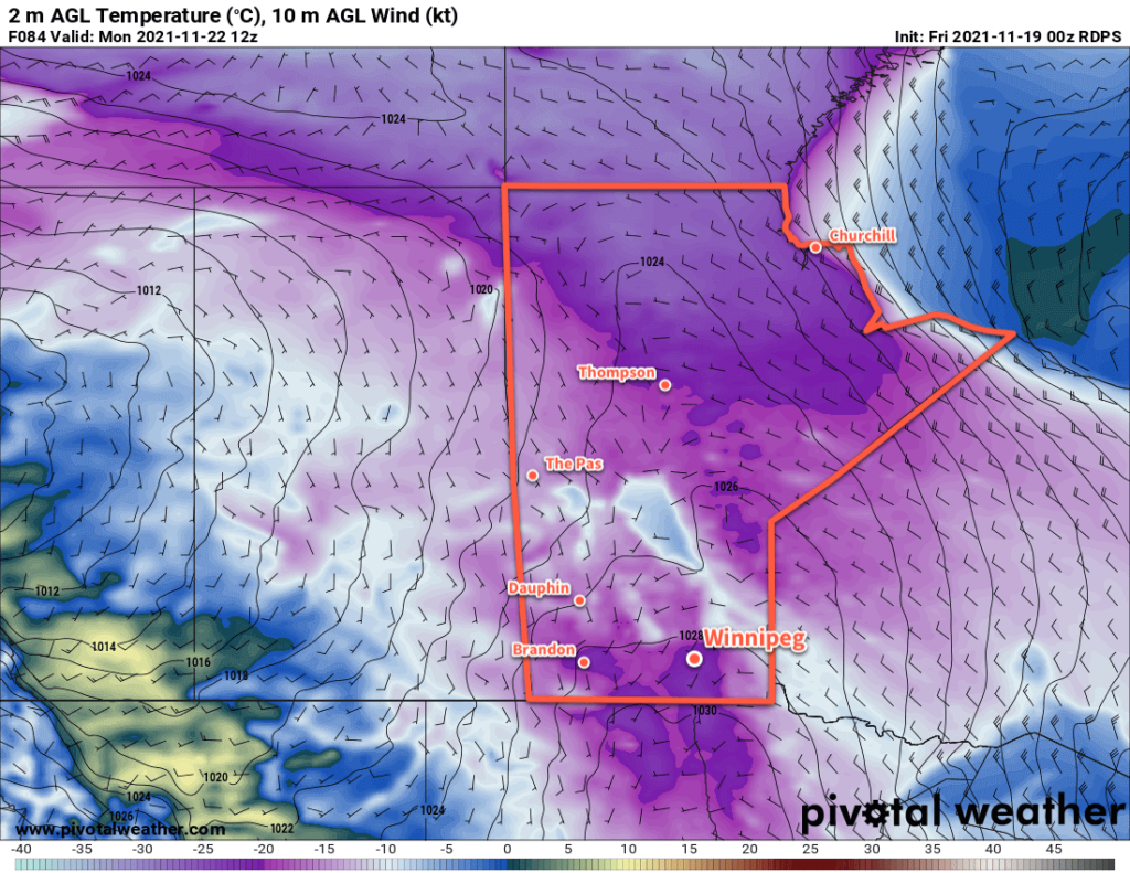
RDPS 2m Temperature Forecast valid 12Z Monday November 22, 2021
Winnipeg’s first taste of bitter winter cold will come on Monday morning with temperatures dipping to -20 °C or colder.

The wind will ease on Sunday evening as a ridge of high pressure moves into the province. Temperatures will dip to a low near -20 °C on Sunday night with mainly clear skies.

Long Range Outlook

Cooler weather looks to stick around next week as winter settles into Manitoba. The region will likely see variable cloudiness through the week, but more snow looks largely limited to Wednesday when another disturbance moves through the province. While no bitterly cold temperatures are in the forecast, the region will be heading into a pattern of near- to below-seasonal temperatures.

Today’s seasonal daytime high in Winnipeg is -3 °C while the seasonal overnight low is -11 °C.