Elsewhere in Weather News: October 18th, 2014

Gonzalo Rolls through Bermuda

Another week, another tropical disturbance forms – this time in the Atlantic. Gonzalo started to organize earlier this week just east of the Caribbean and drifted west, slowly organizing itself at the same time. By the time it reached the eastern islands of the Caribbean such as Anguilla and the British Virgin Islands, Gonzalo was a category one hurricane and brought strong winds and heavy rains to the islands. Hurricane Gonzalo then started curving northeast and quickly strengthened into a category four, with a pinhole eye after it cleared the Caribbean Islands. The storm was then headed for Bermuda, which meant trouble for the small island out in the Atlantic.
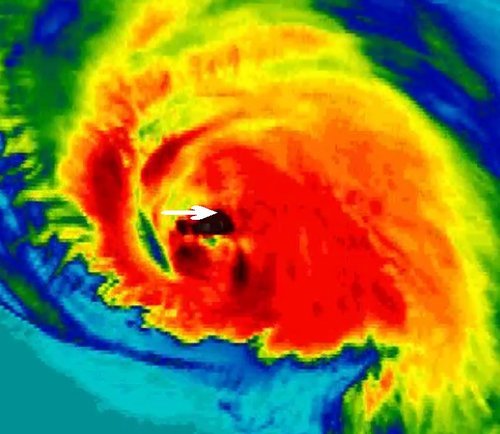
Deep convection in the northern eye wall of Gonzalo depicted by the black colors. Bermuda is identified by the white arrow.

Gonzalo made landfall on Bermuda Friday evening, lashing Bermuda with high end category two winds (175km/h) as the eye wall made its way across the island. Reports of how Bermuda fared were difficult to find as of Friday evening, but it appears the island did quite well with no deaths or injuries reported. However, power was knocked out to about 90% of Bermuda’s residents as well as flooded streets reported. Compared to last week’s EIWN, the big difference is that the infrastructure in Bermuda is built to withstand fairly strong hurricanes, unlike most of the buildings in the region of India that Hudhud affected.
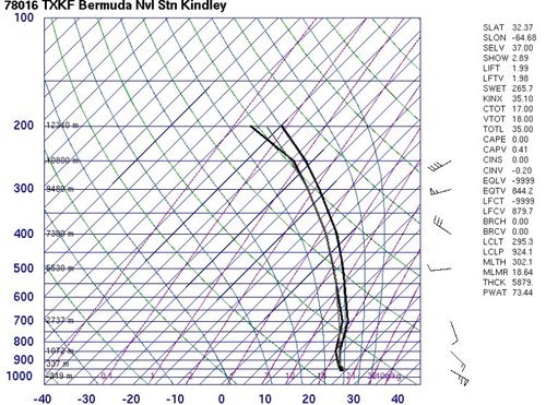
The Bermuda Weather Service launched a weather balloon as the eye approached Bermuda at 00z. (Source: University of Wyoming)

Hurricane Gonzalo will continue its trek northeastwards and may even clip Newfoundland by Sunday as it transitions to extratropical. Interestingly enough, Gonzalo will likely make it all the way to the United Kingdom as an extratropical storm early next week. No other storms are expected in the near future in the Atlantic.
Elsewhere in Weather News: October 11th, 2014

Two Dangerous Storms Spin Up

Notable activity has expanded from the tropical waters of the Western Pacific into the Bay of Bengal over the past week. We mentioned in last week’s EIWN that typhoon Vongfong could be a threat to Japan sometime this week – this has since become a reality. Formerly known as super typhoon Vongfong, typhoon Vongfong took aim at the Japanese island of Okinawa early this morning. Packing sustained winds of 140km/h which gusted to over 200km/h, the storm caused power outages to 27,000 residents and some locations on the island reported over 200mm of rain.

News agencies in the region report 20 injuries as of Saturday morning but thankfully no deaths from the storm. Vongfong is expected to curve northeast and slowly transition to an extratropical storm, but not before it brings significant rainfall to Japan’s main islands. This could be bad news, especially for the mountainous regions, as this is the second storm to hit Japan in the span of a week. With already saturated ground, these regions are more prone to landslides.

Cyclone Hudhud Develops

The second tropical storm is cyclone Hudhud which spun up only a few days ago. With sea surface temperatures approaching the 30°C mark in the Bay of Bengal, Hudhud quickly became a “very severe cyclonic storm” as classified by India’s Meteorological Department. As of Saturday morning Hudhud was 200 kilometres offshore of India with sustained winds of 205km/h.

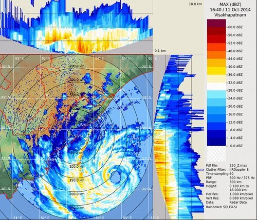
Visakhapatnam radar image of cyclone Hudhud Saturday morning. Outer bands are already affecting India's coast and the eye is visible offshore. (Source: India Met Department)
Visakhapatnam radar image of cyclone Hudhud Saturday morning. Outer bands are already affecting India’s coast and the eye is visible offshore. (Source: India Met Department)

The evacuation of 150,000 people was underway along the coast because a significant storm surge of up to 1.8 metres is expected along the coast. Hudhud is forecast to make landfall overnight tonight just southwest of Visakhapatnam and continue inland, where it will die off, but not before dumping significant amounts of rain. The hardest hit areas can expect over 250mm of rain.

Elsewhere in Weather News: October 4th, 2014

Strong Typhoon Expected to Clip Japan

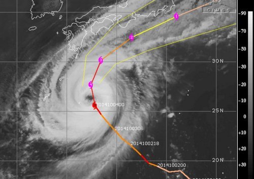
A strong typhoon dubbed Phanfone spun up in the Northwest Pacific this past week and has significantly strengthened since then. Phanfone, which is currently a strong typhoon bearing winds of 195km/h with a central pressure of 935mb is unlikely to make a direct landfall on the main islands of Japan, unless its tracks shifts slightly north. Even if it does not make landfall it is still expected to bring significant severe weather to the region, including Tokyo. The typhoon which is currently heading directly north is expected to start curving northwest today, helped by prevailing winds. As this happens gradual weakening is expected, however, it’s forecast that at its closest point to Tokyo on Sunday the storm will still have sustained winds of 120km/h, likely bringing tropical storm force winds to Tokyo. These winds, combined with the storm surge and heavy rainfall are likely to cause damage, especially in the mountainous regions that are prone to landslides. In preparation for this storm the Japan Meteorological Agency has issued storm surge advisories and high wave warnings for several coastal communities.

IR image of typhoon Phanfone on Friday night at 05z with intensity/track overlaid. (Source: CIMSS)
IR image of Phanfone on Friday night at 05z with intensity/track overlaid. (Source: CIMSS)

Another tropical disturbance that spun up only a few days ago in the Pacific is also the focus of attention this week, even though is not expected to make landfall on any regions any time soon. Vongfong is only a tropical storm currently, but is organizing and is under fairly good conditions for typhoon strengthening. China, Japan and possibly Taiwan will have to keep an eye on this storm by the end of next week but it is still very early to focus in on any specifics for this storm. The storm is expected to make its way through Guam however, as a typhoon, late this weekend.

Elsewhere in Weather News: September 20th, 2014

Odile Makes Landfall

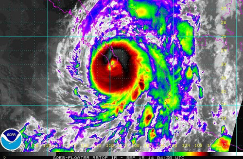
The active Eastern Pacific hurricane season that was discussed in the EIWN post a few weeks ago continues to produce – another major hurricane was spun up this week. This time it was hurricane Odile, a category four at its maximum strength, which bottomed out at a pressure of 922mb. This hurricane, however, headed towards the Baja Peninsula and made landfall there as a category three hurricane on Sunday night.

Odile just as it was making landfall on the tip of the Baja Peninsula. (Source: NOAA)

Cabo San Lucas was one of the resorts hardest hit as Odile brought winds of 205km/h upon landfall. As expected with a hurricane of this magnitude, significant damage was done to infrastructure as well as three deaths were reported. About 240,000 residents lost power during the event prompting school closures and flight cancellations; causing major headaches to travellers in the popular tourist destination. Odile eventually weakened into a tropical storm as it made its way further north, interacting with terrain and beginning to get torn apart by shear. Even though Odile had weakened substantially, the storm was not done causing trouble to people in the US Southwest, bringing with it its plume of tropical moisture. Reports of flooded houses and washed out roads were coming out of southern New Mexico and Arizona on Thursday and Friday where as much as 100mm fell in some towns (Sept. average rainfall is around 30-50mm in the region). Streams quickly became rivers and one resident perished as he got swept away by the floodwaters. It’s not all bad news to the US Southwest though, as drought continues to improve in the region.

Damage at the Los Cabos Airport. (Source: Reuters via Dailymail)

There’s already another storm; Polo, churning in the East Pacific but it is not expected to take the same path as Odile did. No other tropical storms are expected to impact the Baja Peninsula in the near future.