Elsewhere in Weather News: August 16th, 2014

BC Wildfire Threatens Homes

Numerous large wildfires have been burning throughout western Canada this month due to warm, dry weather in the west. Northern British Columbia and the Northwest Territories have been under the gun for most of July and August as ridging in the west has been persistent. The ridge resulted in warm and dry conditions with weak thunderstorms during the day that have been sparking the fires – not a good combination for fire prevention. As a result, a large portion of central and northern BC is now rated for extreme fire danger. A few significant fires are currently burning in northern BC including the Chelaslie Arm Wildfire and China Nose Wildfire.
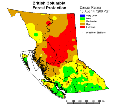
BC fire danger rating as of Friday. (Source: BC Wildfire Management)

The China Nose Wildfire which is burning about 300km to the west northwest of Prince George is, as of this writing, zero percent contained and is threatening some 700 homes near China Lake and Houston, BC. As of Friday, estimates size the fire to be around 4,000 hectares – this is up from 1,200 hectares on Wednesday. A second large fire, the Chelaslie Arm Wildfire, is burning west-southwest of Prince George and is much larger than the China Nose Wildfire with an estimated size of 104,000 hectares. Entiako Provincial Park is most at risk from this fire – the park has closed and is under evacuation alert.
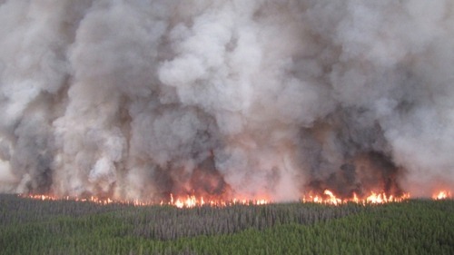
Chelaslie Arm Wildfire, seen from air. (Source: BC Wildfire Management)

Conditions are not superb for firefighting either fire this weekend either; westerly winds kicking in later this weekend will result in warm and dry conditions persisting. These fires can also result in poor air quality, not only for cities in the region but also cities downwind of the fires. Plumes of smoke from the fires in BC and the Northwest Territories can be seen traveling thousands of kilometres – as far as southern Ontario – when a northwest flow is in place.
Elsewhere in Weather News: August 8th, 2014

Multiple Hurricanes and Typhoons in the Pacific

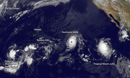
The Pacific Ocean has been busy lately and continues to impress this past week with four different tropical cyclones simultaneously ongoing.

GOES image of Julio, the beginnings of Genevieve, Iselle and Halong (in the top left corner). Taken earlier this week; storm intensities have since changed. (Source: NASA)

The first, typhoon Halong (formerly super typhoon, talked about in last week’s EIWN), is closing in on Japan’s main islands and is forecast to make landfall later this afternoon. Shikoku will be hardest hit; here Halong will make landfall with sustained winds of 120km/h – the equivalent of a category one hurricane.

The second is super typhoon Genevieve. This storm is unusual in such that it was formerly known as hurricane Genevieve – it has since crossed the International Dateline and is now classified as a typhoon. This is the first tropical cyclone to have done this since 2006. Thankfully Genevieve is in the middle of the Pacific and is not expected to make landfall any time soon.

Hurricane Julio is the third tropical cyclone in the Pacific. This one is forecast to pass just north of the Hawaiian Islands. The outer bands of the hurricane are still expected to affect the islands by bringing heavy rains to the now-saturated soils of Hawaii – soils saturated courtesy of the next storm: Iselle.

Tropical storm Iselle is the fourth and has had the biggest impact on American soils. The tropical storm made landfall on the Big Island of Hawaii yesterday and brought with it high end tropical storm force winds combined with copious amounts of rain (over 100mm). Interestingly enough, this is the first time a tropical storm has hit Hawaii since 1992 and the first time since 1952 that one has made landfall on the Big Island. Recovery efforts are still underway with a significant amount of damage to trees and homes on the island. Thankfully, this storm has not been responsible for any injuries or deaths so far.

Elsewhere in Weather News: August 2nd, 2014

Weak Storm Forms in the Atlantic; Typhoon in Pacific

The second named storm of the Atlantic hurricane season spun up this past week and is still churning in the Caribbean. Tropical storm Bertha had sustained winds of around 80km/h as of Friday evening but had lots of dry air to its south and was not very well organized. By this evening it is expected continue its northwest track and pass between Puerto Rico and the Dominican Republic, bringing with it heavy rains as its primary threat. As much as 250mm of rain can be expected in the area which is a cause for concern in the mountainous regions. However, Puerto Rico has been experiencing drought for the past few months; the rain in the forecast is actually a welcome sight. On Sunday Bertha will have more of a northward track, curving up the Gulf Coast and likely dying off to the west of Bermuda due to cooler sea surface temperatures. None of the weather models show Bertha strengthening into a major hurricane and the US mainland is not expected to be impacted by this storm.

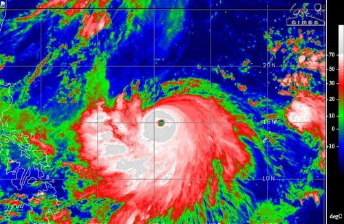
A large, more dangerous tropical disturbance has formed in the western Pacific this week and is already of category three status with sustained winds of 185km/h. Halong has a well-defined eye and eyewall in place, the only thing currently interfering with its development is some dry air to its north. The typhoon is currently located well east of the Philippines and is expected to be of no threat to the country as it will quickly curve Poleward this weekend. It, however, could pose a significant threat to Japan and China next week as it moves into the East China Sea as a strong typhoon. The islands of Okinawa could be in for a strong storm, as depicted by some models, but it is really too early to say for sure.

Typhoon Halong could become a super typhoon if it continues to strengthen at the rate it has been going. IR image taken Friday night.(Source: CIMSS)

Elsewhere in Weather News: July 26th, 2014

Saskatchewan Chase July 24th

An unusually strong upper level low for this time of the year nosed into the southern Prairies and was the focus for severe storms last Thursday. All the ingredients were present for severe storms that day, as Brad alluded to in his discussion of the event posted on the day of. Keeping in mind that this might be one of the last chases this season, due to the jet stream slacking up, a few of us made our way into Saskatchewan to chase the storms.

The day was off to somewhat of a surprising start as we woke up early to find a large squall line was sweeping across southeast Saskatchewan, southwest Manitoba and North Dakota. Thankfully, as the squall line moved away from the main instability axis in the morning it started weakening and its leftover cloud wouldn’t hamper our chances in Saskatchewan for the surface based storm development in the afternoon. After determining that skies would clear in the south-central part of Saskatchewan by late morning, the chase was on. From Winnipeg we drove straight to Brandon, grabbed a quick bite to eat and from there made our way to Weyburn, SK. After arriving in the mid-afternoon, we took a quick look at the satellite only to see some bubbling cumulus and even towering cumulus well to our southwest. By then it was obvious that nothing would fire in the Weyburn area with a stout cap present and no trigger around.

We then had to make a decision to either call it a day or head to south-central SK – where there was plenty of upper forcing and a cold front in the region (further west than what the models were showing). Since we were already that far into SK, we went all in and drove a good 100km west to the Assiniboia region. By the time we got there a couple supercells had already fired; we picked the one that looked best (just south of Assiniboia) and stuck to it.

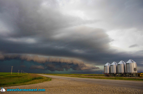
Picture of the storm as it matured, looking towards a section that was bowing out, with a good shelf cloud. (Source: Matt)
Picture of the storm as it matured, looking towards a section that was bowing out, with a well-defined shelf cloud. (Source: Matt)

Following it for over two hours, we were able to spot two funnel clouds. One may have touched the ground, but we were too far away to tell (hence lack of pictures) while the other a brief funnel that spun up later in the evening on the leading edge of a bow echo. We followed the storm which evolved into a line with multiple bow echos embedded along it. Later in the evening the line became elevated, eliminating the wind threat but still able to produce a lot of cloud to ground lightning. The complex eventually died off in southwest Manitoba and left a large area of stratiform rain in the area.

Overall it turned out to be a fun chase day, with a storm that teased us with a few funnel clouds, combined with good structure and a nice light show. What we didn’t see from that day were the large hailstones that were later reported as well as strong wind gusts of 119km/h reported in Assiniboia.