Elsewhere in Weather News: May 17th, 2014

Wildfires Torch California, Helped by Strong Winds and Drought

This past week several wildfires have been burning out of control in San Diego County, just north of San Diego. It is not known whether any of the fires were started intentionally or not, however, the weather has played a significant role in hampering firefighting efforts. As of Friday evening there were four wildfires burning in the county which were all over 1,000 acres in size, and only one of these four was above 25% contained. There are two main points to note of as to why weather has played such a significant role in fueling the fires.
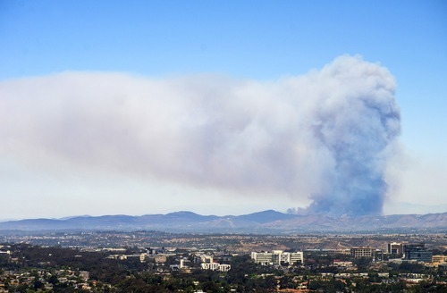
A large pyrocumulus cloud could be seen on Wednesday from San Diego looking towards the Cocos San Marcos fire. (Source: Mashable/Kent Horner)

The Santa Ana Winds are the first to have a big impact on wildfires currently burning out of control in Southern California. These winds occur when air blows towards the Pacific Ocean from the mountain ranges to the east. As the air descends the mountain sides it warms and its relative humidity decreases causing for hot and dry winds. This past week, relative humidity as low as 3% was observed by stations in southern California, coupled with winds of 50km/h, this produced prime wildfire conditions. The second reason as to why the wildfires have been difficult to contain is the current drought situation in the region. A large ridge of high pressure has been persistent over the west coast for most of this past winter and part of this spring, making precipitation difficult to come by. The drought index currently indicates that an extreme drought (second highest tier) is occurring in the region where the fires are burning. In turn, the wildfires have little trouble spreading to moisture-starved vegetation and dried out brush.

This weekend offers a mixed-bag to firefighters. Strong winds and scorching temperatures will persist during the day, but winds will now be out of the west causing for slightly moister air coming onshore from the Pacific. Regardless, the Storm Prediction Center maintains an “elevated” fire risk for this weekend.
Elsewhere in Weather News: May 10th, 2014

Flooding Rains in New Orleans

A weak disturbance tracking across the southern Gulf States was the cause for some flash flooding in New Orleans last night. Precipitable water (PWAT) values exceeding 50mm were present in the area, meaning a very moist atmosphere was in place. Heavy rain fell in the wake of a squall line of storms Friday afternoon into early Saturday morning, causing significant flash flooding in New Orleans. Radar indicated that as much as 125mm fell across the New Orleans and reporting stations in the surrounding area showed widespread 80-100mm readings.

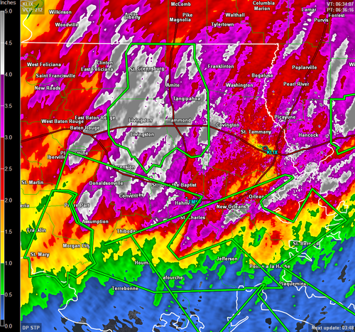
Storm totals according to radar (as of 1am today). Green boxes are flash flood warnings. (Source: GRLevel3)

Flash flood warnings had also been issued by the National Weather Service for most of southeastern Louisiana, including New Orleans. In addition, several water rescues had to be executed in New Orleans due to cars being submerged up to their roof in water. This event comes just over a week after severe flooding affected the Florida Panhandle and dumped over 500mm over some areas.

Severe Weather Expected in the Plains

This weekend looks take an active turn weather-wise across much of the Central and Southern Plains of the United States. A strong low-level jet will aid in transporting significant moisture from the Gulf of Mexico northward ahead of the approaching system. CAPE values are expected to reach very unstable values, especially on Sunday across Tornado Alley; with limited capping (warm air aloft) storms are likely to become severe quickly and tornadoes are possible. Updates on this event will be available in the comments section as the event unfolds!

Following this event, a lull in the storm season is expected across the region for about a week before a return flow sets up and more Gulf moisture is able to start making its way poleward.

Elsewhere in Weather News: May 3rd, 2014

Severe Weather, including Tornadoes Rip through United States

It’s been a rough week in the south-central United States for tornadoes. Monday and Tuesday warranted two consecutive high risk outlooks by the SPC for central Arkansas and Mississippi/Alabama, respectively. The system did continue on further to the Carolinas, but conditions weren’t as ripe for tornadoes. As of Friday evening, NWS had confirmed 67 tornadoes from the outbreak and from these, 11 were of EF-3 strength or higher.

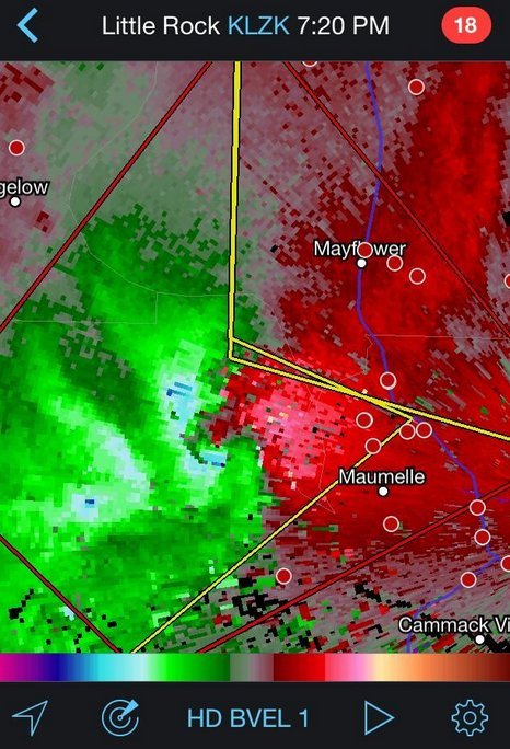
Sunday was predicted to be a big day tornado-wise across Arkansas but cloudy conditions in the morning prevented much daytime heating from occurring. A mesoscale convective system (MCS) had also passed through the region the night prior which could have further disturbed the environment. With that said, the environment did manage to sustain a violent supercell in central Arkansas on Sunday which spawned the EF-4 Mayflower/Vilonia tornado. The tornado was on the ground for a length of 66.5km, at its peak produced winds of 300km/h and had a width of 1.2km. Unfortunately 15 people perished from this tornado.

Velocity data of the Mayflower/Vilonia supercell before it hit Mayflower on Sunday. Notice the intense couplet (red and blues are close), a sign of strong rotation. (Source: Radarscope)

Monday was a threatening day with numerous supercells lined up from southern Tennessee all the way down to southern Mississippi, all a posing threat to drop a tornado because of the volatile environment. The Louisville, MS tornado was one of the most significant one spawned on this day, with an EF-4 rating. It tore through the town killing 9 people and injuring several more. The tornado was on the ground for about an hour, traveling 57km. Another town that took a direct hit on that day was Tupelo, MS. The tornado, which had an EF-3 rating, passed through the northern part of the city taking the life of one person.

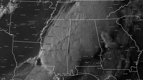
Supercells across the US South on Monday, notice the overshooting tops associated with the powerful updrafts. (Source: NOAA)

Tornadoes were not the only thing that this system produced on Tuesday night as the MCS stalled out over the Pensacola area of Florida producing flash flood conditions across the region. Interstates were underwater, roads got washed out and parking lots full of cars could be seen underwater. Record-breaking amounts were recorded from this event (provided by Jeff Masters blog):

  • 144mm of rain in one hour
  • 520mm of rain for the event

This weekend the pattern is much calmer across the Southern US and Plains as the atmosphere recharges for the next trough coming ashore next week.

Elsewhere in Weather News: April 26th, 2014

Tornadoes Tear through North Carolina

It was an active day severe weather-wise for parts of East Coast yesterday, where tornadoes, large hail and strong winds were all experienced. These severe storms were triggered by a shortwave racing across the mid-section of the US and approaching the East Coast. Moisture was plentiful streaming up from the tropics which promoted low cloud bases and sufficient amounts of Convective Available Potential Energy (CAPE). In addition to this, wind shear was significant enough to support supercells as well as an approaching cold front from the west acting as a trigger mechanism. Considering all of these, conditions were primed for supercells in North Carolina and Virginia.

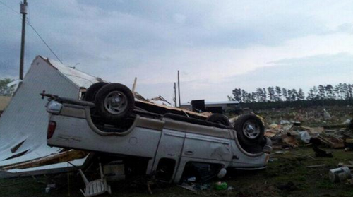
Trucked flipped in Chicod, NC. (Source: WITN)

Supercells quickly formed Friday afternoon across eastern parts of North Carolina and Virginia as the atmosphere destabilized. Elizabeth City appeared to be the hardest hit, likely by straight line winds and not a tornado. As of Friday evening, several injuries were reported because of the strong winds downing trees and power lines in the city. According to the SPC there were 10 different tornado reports which appeared to account for three different tornadoes. Fortunately, no injuries or deaths were reported to be associated with any of the tornadoes.

This event comes at the same time a significant negatively-tilted trough arrives ashore on the west coast. The trough is expected to bring severe weather from the US plains this weekend, to the East coast for the beginning of next week. Sunday through Tuesday look to be the most dangerous days where numerous tornadoes could touch down across Dixie Alley and the Midwest. As of Friday evening, the SPC had already issued a Moderate Risk, mentioning strong tornadoes in their discussion and suggesting a high risk (highest tier) upgrade could be in order in future updates.

With only 89 tornadoes reported in the US as of April 13th, that number could easily double within the next few days.