Elsewhere in Weather News: January 18th, 2014

Severe Californian Drought

A severe drought has settled into a good part of the state of California and is starting to be of concern to residents as numerous brush fires have been sparking up this past week. A strong upper level ridge which has persisted over California for a good part of the past month has diverted all low pressure systems well north into BC. With this, a large area of California has been left dry and drought conditions have worsened significantly in the past month. The Drought Index shows that levels have reached extreme for over 50% of California, including Los Angeles. Los Angeles, on average, receives 80mm of rain during the month of January but they have yet to record any rainfall this January. To make matters worse, no pattern changes are in the forecast; the ridge is expected to remain in place at least until the end of January. Models show no precipitation in the foreseeable future for the southern half of California, which means that Los Angeles has a possibility of going the whole month of January without any precipitation.
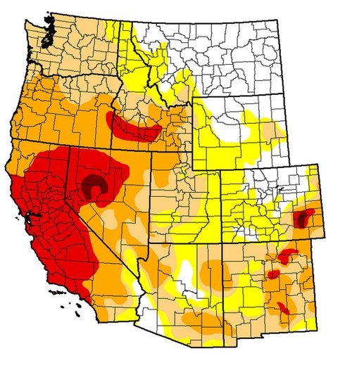

Drought Index for the West Coast, ranging from abnormally dry (yellow) to exceptional (dark red). A good chunk of California is under extreme (red). (Source: USDA)

The snow pack in the Sierras has shown telltale signs of drought with only having 20% of the average snow water equivalents for this time (about 25mm of SWE). In this tweet sent out by the Boise NWS a drastic comparison in the snow pack can be seen over the Sierras. If no significant precipitation arrives before spring, California will be setting itself into a long-term drought.

A drought emergency had been issued for California, asking residents to limit their use of water. Bushfires have been flaring up due to the dry conditions, including the Glendora fire which is a fire that started on Thursday and has already burned 1,700 acres east of Los Angeles. Santa Ana winds gusting to 35km/h have been fueling the fire and will continue to do so until tomorrow, making it difficult for crews. Relative humidity in the area has a chance to dip as low as 5% during the day – making for ideal wildfire conditions. This has prompted the National Weather Service to issue a red flag warning east and northeast of Los Angeles.

Elsewhere in Weather News: January 11th, 2014

Cyclone Ian Hits Tonga

This year’s first strong cyclone has spun up in the Southwest Pacific of the Southern Hemisphere. The cyclone – cyclone Ian, formed to the southwest of the Samoan islands and quickly strengthened under prime conditions for intensification. Yesterday the strongest part of Ian clipped the islands of Tonga, as a category four bearing winds around 225km/h and an estimated central pressure near 950mb. All kinds of hazards are associated with a cyclone of this strength: landslides, storm surges and flooding. These risks are enhanced because this cyclone is slow moving. Communications had been cut off from the northern islands on Friday night, where a state of emergency had been issued, therefore the scale of damage to the island remains unknown there. The island of Hunga had reported damage to homes that had their roofs blown off. Tonga’s capital, which is about 100km further south than the northern islands, did not take a direct hit and only minor damage/flooding has been reported there.


A small, but compact cyclone Ian can be seen on IR satellite passing over Tonga on Friday evening. (Source: CIMSS)

The cyclone is expected to continue moving southeast into the south Pacific where it will die off due to cold sea surface temperatures; unfavorable for development.

Australia Baking Under Intense Heat

In other news, Australia is experiencing an intense heat wave which broke numerous daily records as well as a few all-time records such as the new all-time high of 48°C reached at Narrabri on January 3rd. The country has been plagued with heat waves the past few years, including last year which was Australia’s warmest year on record since records started.

Elsewhere in Weather News: January 4th, 2014

Snowstorm Sweeps across Northeast US, Cold Temperatures Follow

A powerful low off the Atlantic coast impacted the Northeast US this past Thursday/Friday bringing heavy snow to the region and blizzard-like conditions. Blizzard warnings were issued for Cape Cod and surrounding regions as winds howled around 70km/h and heavy snow fell. Conditions did improve snow-wise late Friday, but very cold Arctic air ushered in behind the low was of concern. In total, about 4,500 flights were cancelled out of New York alone, causing problems for holiday travelers. Schools and most government offices were closed in Washington DC on Friday due to the adverse weather conditions. Boxford, Mass appeared to be hardest hit with snowfall totals around 60cm, however, Boston was not far behind with 45cm followed by New York’s 25cm. On Friday night 16 deaths had been reported to be associated with the storm.

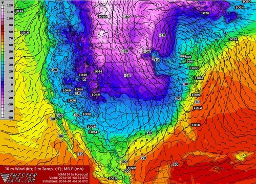
Temperatures are expected to rebound and warm up for the Northeast as another low pressure system approaches, from the west. It will draw in some warm air; highs Sunday (overnight) are even expected to rise in the (positive) double digits making for a 30°C temperature swing in less than 48 hours for parts of the Northeast.


Arctic air infiltrates across the Northern Plains, US Midwest behind the low centered in southern Quebec. Valid Monday morning. (Source: Twisterdata)

Some potentially record-breaking low temperatures are expected on the horizon for the Midwest behind this system though, as the polar vortex pivots all the way down to the Midwest. On Friday the Governor of Minnesota had already cancelled schools state-wide on Monday in preparation for this next potent blast of Arctic air that will make its way east.

Elsewhere in Weather News: December 28th, 2013

EIWN’s Top 3 Events of 2013

This past year several historical events have taken place – from right here in Canada, to Tornado Alley, to half-way across the globe in the Philippines. The post this week will feature a countdown of this year’s top 3 severe weather events.

3. Alberta Floods – June 19th to June 22nd

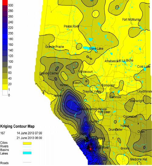
This event was fuelled by moisture from the Gulf of Mexico that was able to stream all the way north to southern Alberta, where an upper low was positioned. The situation would not have been as bad if a blocking pattern wasn’t in place further north, stalling the upper level low over southern Alberta. As all this moisture was pushed up the Rockies, condensed, and further, fell as precipitation leading to significant flooding along the foothills. Extreme rainfall amounts were recorded in Canmore at 220mm (half their annual rainfall) and High River which recorded 325mm, both in less than two days.


Rainfall totals for Alberta up to the 21st of June, note the high amounts along the foothills. (Source: AB Environment)
Rainfall totals for Alberta up to the 21st of June. (Source: AB Environment)

This severe weather event was the costliest in Canadian history, reaching two billion dollars in damages. An estimated 100,000 residents were forced to evacuate, a total of 32 communities were in a state of emergency and 2,000 armed forces were brought in to help out. Unfortunately, four people lost their lives in this event.
A few more facts from the event:

  • The Saddledome (home of the Calgary Flames hockey team) flooded up to the 10th row of seats
  • Over 1,000km of roads were destroyed
  • Calgary received 88% of their average monthly precipitation within 48 hours

2. Moore Tornado – May 20th

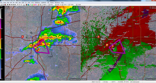
On the afternoon of May 20th, one of the worst scenarios possible occurred; tornadic supercells spawned a strong tornado on the ground and tore through a city of 50,000 people. Conditions were ideal for supercells to develop as the CAPE was in the 5000J/kg, shear was in the 50kt range and a dryline trigger was present. The city of Moore, Oklahoma took a direct hit from an EF-5 tornado. The massive tornado, which had a maximum width of 2.1km, raced across Oklahoma for 27km before it eventually lifted after passing through Moore.


Radar scan (reflectivity and velocity) at the time the tornado hit Moore. Large debris ball present on the radar over the city as well as a tornado vortex signature. (Source: Personal files/GR3 radar)

Damage in Moore was severe as whole neighbourhoods were swept off the map. An estimated 1,150 homes were destroyed with a total of two billion dollars in damages. The tornado also took the lives of 24 people and injured 377, but the toll could have been significantly higher had the NWS not put out a strongly worded warning for the Oklahoma City/Moore area a good 15 minutes before the tornado arrived.

Interestingly enough, 11 days later the widest tornado on record touched down in El Reno, Oklahoma measuring 4.2km in width, just 60km west of Moore. This tornado was rated an EF-3 and sadly took the lives of 8 people, including the respected researcher and storm chaser Tim Samaras.

A few significant facts from the Moore tornado:

  • The Storm Prediction Center had issued a moderate risk with a 10% hatched tornado risk for the area that day
  • A 10-ton water tank was thrown one kilometer away
  • The tornado was on the ground for almost one hour

1. Super Typhoon Haiyan – November 3rd to November 11th

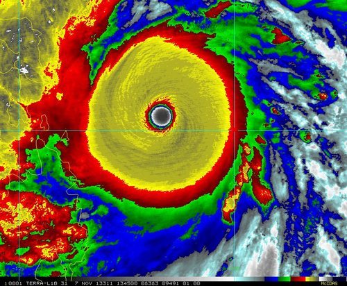
Our top weather story is one that is still fresh in our minds. Typhoon Haiyan (also known as Typhoon Yolanda) made landfall in the Philippines as a strong category five typhoon, bearing winds of approximately 315km/h and a central pressure below 900mb. With these values, Haiyan would be the strongest tropical cyclone to ever make landfall.


IR image of super typhoon Haiyan 5 hours before it made landfall in the Philippines. (Source: Co. State University)

In total, 7,000 people perished from this storm, with still a thousand missing, making it the deadliest typhoon on record in the Philippines. Extreme damage totaling an estimated 1.5 billion dollars occurred mainly due to wind and storm surge. Tacloban was the hardest hit city as the storm surge of 6m took out buildings over one kilometer inland. 90% of the city was reported to be destroyed.

A few significant facts from super typhoon Haiyan:

  • 11 million people were affected by Haiyan
  • Haiyan made a second landfall in Vietnam as a category one typhoon
  • 4 typhoons made landfall in the Philippines in 2013 (Utor, Nari, Krosa, Haiyan)