Above Average Western Pacific Typhoon Season Continues to Produce

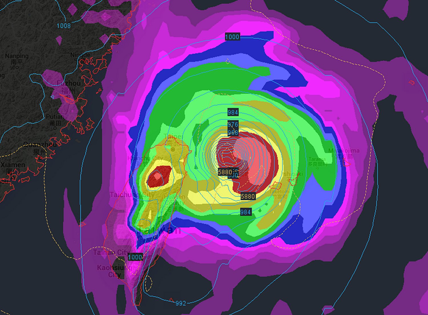
Typhoon Dujuan formed earlier this week on Wednesday in the middle of the Pacific Ocean and continues to barrel westward toward northern Taiwan and the eastern shores of China.

[map type=”terrain” autofit=”1″ disable_scrollwheel=”1″] [pin]Taipei[/pin] [pin]Wenzhou[/pin] [/map]

The Western Pacific typhoon season, which is running above average this year with already 21 named storms, has primarily affected Japan, China, and the Philippines. The average number of named storms for a full season averages around 25 storms (May until late October is peak Western Pacific storm season, but storms can form outside this period). Dujuan currently sits about 1200km east of Taiwan shores and is still undergoing intensification. As of Friday night the storm had sustained winds of 167km/h, gusting up to 200km/h and had an estimated central pressure of 960mb. The Japan Meteorological Agency forecasts that by the end of the weekend it will have intensified to a high end category four equivalent storm as it approaches Taiwan. With sea surface temperatures in the order of 30°C and shear values between 5-10kt their forecasts for a powerful typhoon is warranted.

Infrared satellite imagery of Dujuan on Friday night shows very cold tops on the south side of the eyewall and an eye that has cleared out nicely. (Source: UW-CIMSS)

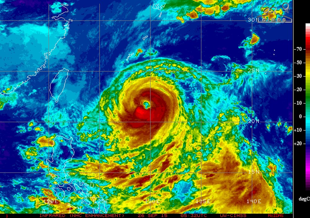
Latest 00z forecast models on Friday night had the storm brushing northern Taiwan and then pushing onto China’s mainland by Monday night near the city of Wenzhou. With a track like this, northern Taiwan would take the brunt of the storm with severe storm surge, high winds and heavy rain, while the threat to China wouldn’t beas major they would still see extremely heavy rainfall with the remnants. However, it must be noted that there is much uncertainty about the specific track still and the storm could deviate from current model forecasts.

Only one of the numerous forecast models' output for Dujuan. This one from the 25/12z ECMWF - brings the storm down to 935mb near northern Taiwan. (Source: Wunderground)
Only one of the numerous forecast models’ output for Dujuan. This one from the 25/12z ECMWF – brings the storm down to 935mb near northern Taiwan. (Source: Wunderground)

Japan Faced with Severe Flooding

The worst flooding that some parts of Japan have seen in decades occurred this past week as a tropical storm brought tropical, moisture-laden air to the country.

[map autofit=”1″ disable_scrollwheel=”1″] [pin]Sendai[/pin] [pin tooltip=”Ikari”]Ikari Nikko, Tochigi Prefecture 321-2806[/pin] [pin]Nikko[/pin] [pin]Kanuma[/pin] [pin]Tokyo[/pin] [pin tooltip=”Joso”]Joso, Japan[/pin] [/map]

Tropical storm Etau had the worst impact on Japan’s biggest island, Honshu. Here heavy rain bands were set up for over 24 hours in the area and rainfall totals were further enhanced by local topography. Unstable terrain leading to mudslides also grew to be a concern as heavy rain fell and the ground became saturated. By the end of this past week, when the rain was all said and done, some villages in central and southern Honshu had rainfall totals near 700mm, with some 24 hour totals topping 500mm. It’s to note that the average monthly rainfall for September in Tokyo is less than a third of that (181mm). Here are a few of the notable rainfall amounts (provided by weather.com) :

  • Ikari 551*mm* in 24 hours.
  • Nikko 668*mm* rainfall total.
  • Kanuma 444*mm* in 24 hours, which is more than double the previous 24 hour record for the city (record 212*mm* in 2002).
  • Sendai central business district 269*mm* 24 hour total
Levees of the Kinugawa River breached in Joso from the heavy rains. (Source: AFP/via TWC)

What resulted from these very high rainfall amounts was historic flooding, mainly north and northeast of Tokyo. Over 13,500 buildings were reported to be completely flooded out by officials in result of the heavy rain falling as well as some levees being breached north of Tokyo. In total 3 people have been confirmed to have died from this rainfall event and 23 are still missing; mostly from landslides. It was reported that 185,000 were forced to leave their homes, while over two million more were advised that they should leave by authorities. It’s not possible to assign a dollar amount to the damages yet but authorities speculate it will at least be in the hundreds of millions.

Flooding in the city of Joso, where floodwaters nearly reached the second story of homes. (Source: CNN)

A few showers are expected this weekend in the Tokyo area but nothing close to the magnitude of what seen this past week.

Massive Hail Pummels Central Italy

Conditions were ripe overnight Friday into Saturday morning in Central Italy for severe thunderstorms – these brought very large, damaging hail to the region.

[map autofit=”1″ disable_scrollwheel=”1″] [pin]Tyrrhenian Sea[/pin] [pin]Pozzuoli[/pin] [/map]

A large upper level trough to the west of Italy, slowly digging eastward provided sufficient lift, as well as strong upper level winds contributing to sufficient shear being in place for severe storms. Ahead of this trough, a large area of very warm, moist air originating from the Mediterranean was present. In this warm and unstable environment, MLCAPEs of 3,000J/kg were in place which was more than enough to sustain strong updrafts. Finally, slicing into this airmass was the cold front which acted as a mechanism to trigger the storms. With all of this combined ESTOFEX (European Forecasting Storm Experiment) had issued a maximum level three watch area – meaning that there was a 15% chance of “extremely severe weather” being reported within the area of concern.

This forecast definitely checked out. On Saturday morning, local time, a supercell fired over the Tyrrhenian Sea (which later evolved into a well-organized MCS) and brought with it 10-12cm diameter hail to the city of Pozzuoli Italy, located near Naples. To put this into perspective, you would need an updraft velocity speed of roughly 170km/h to suspend a hailstone of that size. Widespread damage occurred to an estimated 70,000 buildings, vehicles could be seen with major dents and blown out windshields and crops/livestock sustained major damage in the area, thankfully there were no injuries to residents reported.

Erika: Yet Another Tropical Disturbance in the Atlantic

Yet another tropical disturbance has developed over the Atlantic this week thanks to another mid-level wave traversing off the coast of Africa westwards over the Atlantic. It’s currently impacting the Dominican Republic and is forecast to head west-northwest towards the southeastern United States.

[map type=”terrain” autofit=”1″ disable_scrollwheel=”1″] [pin]Dominica[/pin] [pin]Dominican Republic[/pin] [/map]

Erika, which formed near the Cape Verde Islands, was centered near the southwest corner of the Dominican Republic as of Friday night bearing sustained winds of 75km/h and a rather unimpressive pressure of 1000mb. The tropical disturbance has struggled mightily at getting even somewhat organized over ocean waters; dry air and strong shear were both contributing factors to this. Erika is expected to continue experiencing problems organizing in the near future due to the strong wind shear in place, as well as a new concern – the rugged islands of Hispaniola.

IR satellite image of Erika on Friday night. Erika looks rather disorganized due to relatively strong shear present, but could still bring heavy rainfall to some Caribbean Islands. (Source: NHC)

The heavy rains that accompany this tropical disturbance are not to be underestimated, however. Heavy rainfall in the order of 100mm to 150mm, as high as 250mm locally, is expected to fall across both the Dominican Republic and its neighbouring country, Haiti. There have already been 20 confirmed deaths associated with Erika from the island of Dominica (located in the Lesser Antilles), and three dozen more residents are still missing. In consequence, this tropical storm has been the deadliest natural disaster for the country since 1979.

The future of Erika remains uncertain at this point. Most models show Erika as weakening over the Caribbean islands (due to the shear/terrain problems discussed), then emerging over waters off of the western coast of Florida as a weak tropical storm. Overall, it’s unlikely that Erika will become anything more than a tropical storm that is just a rain-maker for southeast US.

In other news, it had been the year of the hurricane in the Eastern Pacific near the Hawaiian Islands. Several hurricanes have brushed by Hawaii already this year – an unusual occurrence. Yet another is on its way in the coming week. Hurricane Ignacio (category one) is expected to pass close to Hawaii. What remains to be seen is how close – Hawaii can at least expect high surf and heavy rainfall from the outer bands of Ignacio on Monday, but there is still some uncertainty on strength of the winds which depends on how close Ignacio comes. Another hurricane in the Eastern Pacific is churning; Jimena, is a high-end category four but is not expected to have any impact to land in the near future.