Elsewhere in Weather News: September 14th, 2013

Historical Flooding in Colorado

This past week Colorado has been absolutely swamped thanks to moisture streaming up from the Gulf of Mexico, riding up the Rocky Mountains (upslope flow) and then falling as rain. High pressure sliding down from the north in the US Plains as well as an upper-level low to the west drew in the moist air from the southeast. Generally, 850mb dewpoints could be found in the 15°C range and PWAT values around 40mm in Eastern Colorado. Plentiful moisture was in place – a recipe for heavy rains that had the possibility to fall for a long period of time. This became the case for Wednesday evening through Friday morning for Boulder, Colorado and surrounding communities.
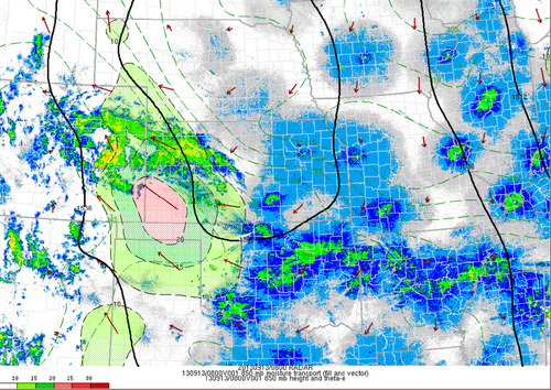
850mb moisture transport

Radar with overlay of the 850 moisture transport, notice the vectors all pointing towards the Rockies. Taken Friday 3am. (Source: SPC Mesoanalysis image archive)

As best described by NWS Boulder, flooding of “biblical” proportions took place is continues as of Friday night. Small creeks easily turned into raging rivers that inundated whole towns and mudslides blocked highways, took out buildings. The death toll is already at four but concerns of more as 172 people are still missing and some communities are literally cut off, with no roads leading in or out of town. Interstate 25 had been closed due to water running over it as well as numerous other highways that had simply been washed away.

The average rainfall per year for Boulder, CO is around 525mm, this means that in a few days Boulder got over half its annual rainfall at 310mm. This easily beats out the old record for rainfall in September (243mm), and average of 43mm (this month; 721% above average September rainfall). Interestingly enough, the area which received all this rainfall was under a moderate to extreme drought as per the Drought Index.
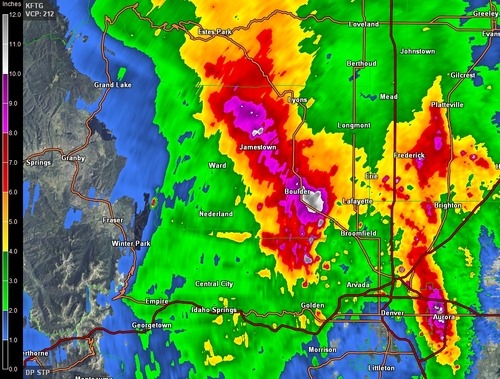
Rainfall estimates

Estimated rainfall from KFTG as of Friday 3am. Notice the dark purples/white; areas above 200mm estimates. Map storm total accumulation. (Source: GRLevel3)

It appears as though Boulder might get a break from the rain today as the upper-level low weakens and moves further east though there is still a slight chance for pop-up (non-severe) storms. Tomorrow will likely bring with it more rain for the region, unfortunately.
Elsewhere in Weather News: September 7th, 2013

Tropical Storm Gabrielle Drenches Parts of Caribbean

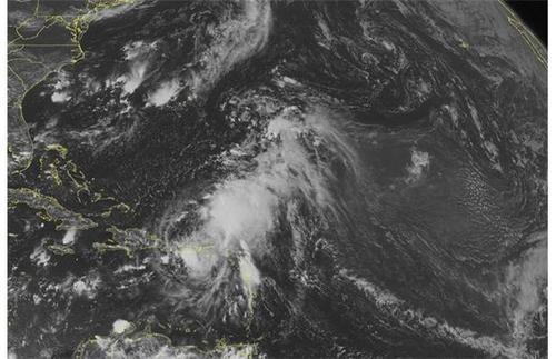
The seventh storm of the Atlantic hurricane season spun up this past week, though did not affect the continental United States. The tropical storm, Gabrielle, did not reach hurricane status due to unfavorable conditions for storm development, including shear levels being on the high side. Shortly after it made landfall on Thursday it had been downgraded to tropical depression status. Drenching rains still fell across Puerto Rico, Dominican Republic and the US Virgin Islands thanks to Gabrielle’s southerly flow bringing in copious amounts of moisture (PWAT values approaching 75mm) from the Caribbean Sea.

Gabrielle

Gabrielle shortly after it got downgraded to a tropical depression on Thursday early afternoon. (Source: WUnderground)

As of Friday morning the highest rainfall amounts came out of St. Thomas where 175mm had already fallen. In general anywhere between 100mm to 250mm will have fallen across the region after Gabrielle has moved off to the north in the middle of the Atlantic Ocean. Friday evening the storm had been almost completely torn apart north of Puerto Rico and wasn’t a threat to land anymore. No deaths or injuries have been reported with the storm.

Surprisingly there has not been one hurricane in the Atlantic so far this year and if there continues to be a lack of hurricanes until September 16th, a record for the latest start to a hurricane season (since records began) would be achieved. However, longer range models such as the GFS have been showing tropical development in the Caribbean as well as another wave coming off Africa’s west coast in the near future which will be something to keep an eye on.

Elsewhere in Weather News: August 31st, 2013

Flooding Problems for Taiwan

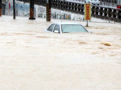
This past week the southern half of Taiwan has been experiencing significant flooding following a tropical storm that made landfall. Tropical storm Kong-Rey made landfall on the 29th bringing with it drenching rains. Very high rainfall accumulations along the west coast of Taiwan were reported, 500 millimeters in some areas within a span of 48 hours. That’s about as much rainfall as Winnipeg gets in a year! The flooding rains made so that second-story levels of building were underwater in some areas. Around 3,600 people had to be evacuated of the low lying areas while three perished in the floods.

Kong-Rey flooding

Flooding in Minsyong, Taiwan. (Source: Focus Taiwan News)

Kong-Rey has since moved off to the north-east and skirted around Japan’s west coast. No severe weather was experienced in Japan since it has been downgraded to a tropical depression and had significantly weakened. As of Saturday morning not much was left of the tropical depression as it has continued drifting into the Pacific and will die off there.

Elsewhere throughout the globe not much significant weather has been occurring this week. The Atlantic hurricane season has been remarkably slow this year with no hurricanes and only six tropical storms. No hurricane development is expected in the next few days, though September is on average the most active month of the year in the Atlantic.

Also, a quick update on the large California wildfire burning near Yosemite; the fire is now about a third contained as the crews continue to battle the fire. The weather pattern is expected to remain relatively the same as last week over the area – warm and dry for the coming week.

Elsewhere in Weather News: August 24th, 2013

California Wildfires Threaten National Park

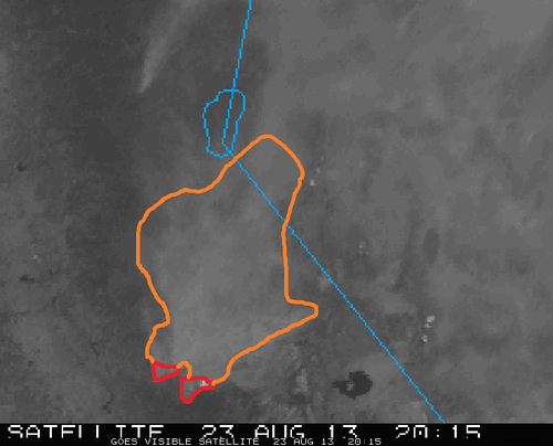
A small wildfire started about a week ago in the back country trails of the California forests near Yosemite National Park has now turned into a raging wildfire. The wildfire which was initially located outside park boundaries has recently encroached on the national park territory. Covering about 425 square kilometers, the fire is only 2% contained bringing concern to many residents in the area who are under voluntary evacuations. Twelve buildings have been damaged or destroyed by fire already and another 4,500 around Yosemite are at risk. In all, 7,000 firefighters were brought in to battle the wildfire.

Wildfire smoke

Visible satellite shows extensive amount of smoke in eastern California. Smoke outlined in orange, red the location of the Yosemite fire. (Source: CoD satellite)

Very dry heat has been in place over the region for the last week priming the conditions for wildfires. Relative humidity values are expected to remain in the single digits, combined with temperatures in the mid to high twenties, no relief will be provided to the firemen battling the blaze. Drought has persisted since the beginning of summer for much of California and as of Friday 98% of the state is experiencing drought, with the severity ranging from moderately dry to extreme. Due to the dry conditions, 15-20 large wildfires are currently burning in California.

Usually, the wildfire risk peaks in late September in California as the Santa Ana winds come into play. Santa Ana winds are severe winds that are funneled through the mountains. As these winds are funneled through and descend in height (moving towards the coast) they are heated by natural processes, namely, adiabatic heating, causing for extremely hot and dry weather. These easily spread wildfires by blowing embers towards flammable vegetation.