Elsewhere in Weather News: February 16th, 2013

Tornado Hits Hattiesburg, MS

The Deep South in the United States experienced another round of severe weather this past Sunday as gulf flow brought moisture and other crucial ingredients –such as vertical wind shear and forcing– to the area, creating ideal conditions for the spawning if tornadic supercells.

The tornado that occurred late Sunday afternoon and travelled through Hattiesburg Mississippi (population 51,000) was the strongest tornado of the outbreak (total of 14 tornadoes) and caused the most damage. Rated as a low-end EF-4, the Hattiesburg Tornado made its way through the north-west side of the city. It tore off roofs, took down brick walls, and caused damage to the south end of the University Southern Mississippi campus. Two dozen injuries were reported and no fatalities occurred with this tornado, thanks in part to quick warnings issued by the NWS citing that there was a confirmed tornado heading towards the city.

Video of the Hattiesburg, MS tornado as it passed through the north-west part of town. (Source: Youtube – tarah106)

With these additional 14 tornadoes, the United States is running slightly above their tornado average of 73, with a current count of 103 tornadoes. All 103 tornadoes occurred in the Southern and Midwest US. What remains to be seen is how the peak tornado season will play out in April/May in Tornado Alley where they are currently experiencing significant drought. The lack of moisture in that area could impact the season’s typical storm activity.
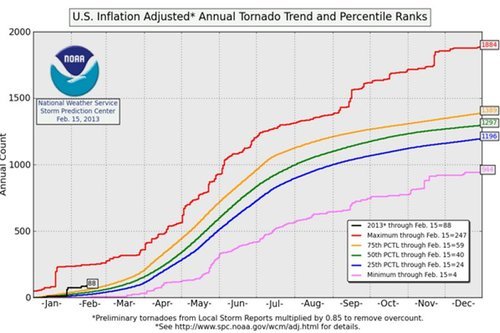
NOAA graph

US (inflation adjusted) tornado percentile ranks, created by NOAA – SPC. (Source: NOAA)

Elsewhere, there has not been much extreme weather other than more hot temperatures for Australia and a weakening tropical cyclone Indian Ocean (Gino) which managed to reach category two earlier this week.
Elsewhere in Weather News: February 9th, 2013

Snowstorm Hits Moscow

On Tuesday, this past week, Moscow experienced yet another significant snowstorm which caused significant disruptions to traffic and was also the reason for numerous power outages. Several low pressure systems have been steered through the western half of Russia as a strong high pressure remains in place over Central Russia. This has put Moscow in a good spot to receive repeated bouts of snow. The most recent of their snowstorms brought 25cm of snow on Tuesday which meant significant traffic disruptions – as many as 3,000 accidents were reported by Moscow Police.

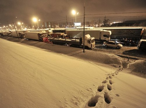
Moscow traffic jam

Moscow traffic backed up because of snow. (Source: RT)

On average, Moscow receives about 150cm of snow every winter but this year has been significantly above average in terms of snowfall. Winter 2012-2013 totals for Moscow are already at 216cm and with another month and a half to go with the possibility of snow it could be a long, cold spring for Moscow. The weather will turn cold and dry for Moscow next week as the strong high pressure expands a little further west.

New England Snowstorm

Another snowstorm, a little closer to home, is bringing significant amounts of snow to parts of the Eastern Seaboard – more notably New England. The deep low pressure system is located just off the East Coast and has a sharp deformation zone bringing heavy snow and even “thundersnow” to the Atlantic States. The highest accumulations are expected to reach around 80cm (could be higher locally) and it was not uncommon to see snowfall rates of 8cm/h on Friday evening! Power outages were the main concern to residents as below freezing temperatures move in. As of Friday night 500,000 people were without power across the North East US.

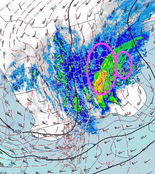
500mb analysis

500mb analysis when the strongest bands of snow were in place, at 9pm. Circled areas where the heaviest snow is expected to fall on Friday overnight. (Source: SPC)

Updates on this storm and snowfall totals will be forthcoming in the comments section as the low pulls off into Atlantic Canada.

Elsewhere in Weather News: February 2nd, 2013

First Moderate Risk of 2013, Tornadoes in Southern US

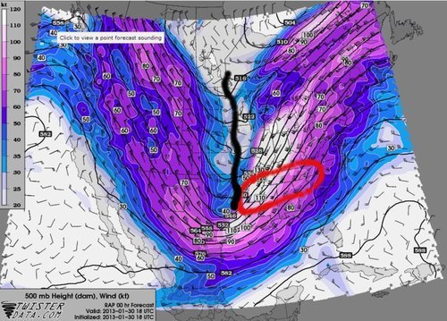
A severe weather outbreak occurred this past week across a large part of the southern United States. The outbreak was well forecasted by the SPC as they issued a ‘moderate risk’ warning in their two-day outlook. With a strong gulf flow bringing in copious amounts of moisture, dewpoints rose into the mid-sixties, creating enough instability for thunderstorms. This, coupled with a very strong low-level jet, much shear, and an approaching trough of low pressure, created conditions ripe for dangerous storms.

500mb map

500mb analysis with trough of low pressure as black line and red circled area as hardest hit areas. Taken 1pm January 30th, just after the Adairsville Tornado.(Source: Twisterdata)

Taking both January 29th and 30th weather activity into consideration, 41 tornado reports and over 600 high wind reports were submitted. These high wind reports can be attributed to winds reaching 130km/h just above the surface, associated with the low level jet (850-925mb), and brought down to surface in thunderstorms.

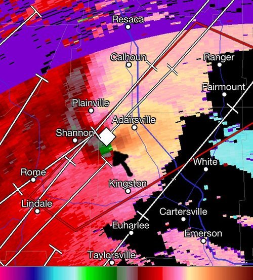
The strongest tornado to occur in this outbreak appears to have been the Adairsville (Georgia) Tornado, which was a large wedge tornado and rated by the NWS to be of high-end EF-3 strength (10km/h short of EF-4). This tornado was spawned by a supercell that was slightly ahead of the front and its inflow was not disturbed by any other cells in the area. The tornado’s track was about 35km long and was nearly one kilometer wide. Severe damage was done to the town of Adairsville, where around 60 buildings were destroyed, one person lost their life, and another 17 were injured.

Velocity Adairsville Tornado

Hi-res velocity image just before the tornado went through Adairsville – notice the contrast between bright green and brown. (Source: RadarScope)

The large low pressure system not only caused grief to the southern states, but it also created issues on the back side of the low pressure system where flash freeze weather caused large pileups on interstates. The northern half of the US Midwest received 20cm of snow.

There are signs that another trough might emerge from the Rockies late next week and into the weekend, and bring with it another round of severe weather to the southern US. There is much uncertainty as to the timing and exact location as there is still a fair amount of time until the event.

Elsewhere in Weather News: January 26th, 2013

Oswald Brings Significant Rainfall to Queensland

Southern Australia’s heat wave came to an abrupt end this week thanks to a potent trough that made its way across its southern half. This trough ushered in cooler air and more reasonable highs can be expected with lows in the teens as opposed to the high twenties that they were experiencing last week.

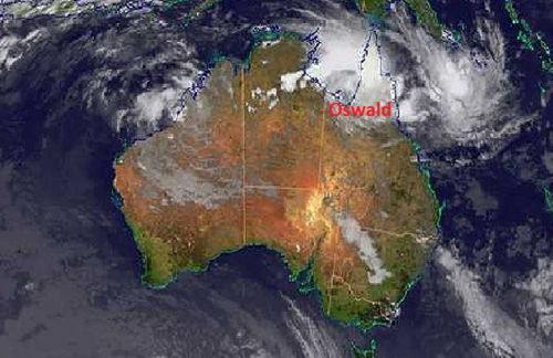
Oswald satellite

Satellite image of Oswald in its early stages, taken on January 21st. (Source: Australia’s BoM)

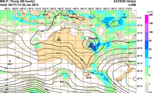
However, a tropical disturbance, as predicted by the models last week has organised and brought much moisture to Queensland as it made its way south and transitioned into an extratropical storm. Formerly known as tropical storm Oswald, the extratropical storm has dumped over a metre of rain (1000mm) in some areas of Queensland causing for flash flooding concerns. As of Friday evening, 11 flood warnings were in effect (all in Queensland) as well as some wind warnings for the higher elevations and coastal areas. Peak gusts of 115km/h were recorded with Oswald’s passage. It appears as though residents were well prepared as not much damage was reported and only one rescue had to be executed off the coast.

MSLP/rainfall Oswald

MSLP and rainfall for Saturday morning. (Source: Australia`s BoM)

The extratropical storm will get pushed out to sea ahead of the trough early next week giving way to calmer weather for Queensland. Areas of North-East Australia will remain under very warm conditions (over 40°C) through next week, combined with relative humidity below 20%. This could cause some bushfires and Fire Weather Warnings might have to be issued by the Bureau of Meteorology.