Elsewhere in Weather News: January 20th, 2013

Intense Heat Wave Continues in Australia

A significant heat wave has remained in place for most of Australia’s southern half, this past week. The large ridge of high pressure has kept about 70-80% of Australia under extreme high temperatures (over 40°C) and in turn has created dangerous conditions in which bushfires can occur. Total burn bans were in place for a few communities in the southern half of Australia and firefighters are on high alert. As of Friday there were 142 bushfires burning in New South Wales alone and 29 of them were 0% contained.
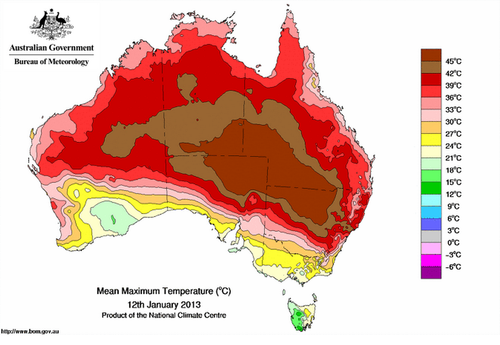
Temperature map

Map of Australia’s extreme temperatures on January 12th, 2013. (Source: Australia’s BOM)

Residents of Tasmania have been experiencing similar weather conditions this New Year, contributing to a massive brushfire that had been raging through a large area of its south-eastern peninsula two weeks ago. Here, 1,000 people had to be rescued by boat from their homes. The damage in that area has not yet been tallied, but at least 20 houses, including a school, has burned down to the ground and at least one person is confirmed dead.

On Friday, January 4th, the village of Wudinna, located on Australia’s southern coast, reached extreme temperatures of 48.2°C, and various other cities broke their daily temperature records as well. Adelaide recorded all-time January high temperatures on the same day as the mercury rose to 44.1°C. Even more impressively, on January 12th Moomba (South Australia) managed to reach a temperature of 49.6°C – Australia’s hottest temperature in 15 years. The average temperature for Southern Australia ranges between 25°C and 35°C in January, and a little cooler for areas along the coast. This past week, Australia’s Bureau of Meteorology even had to go to the extreme by changing the temperature scale on their maps because temperatures constantly exceeded the scale during this intense heat wave.
Trough

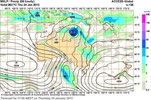
Potential through coming through which would help cool down the temperatures late next week. Also to note a possible tropical disturbance on Australia’s north side. (Source: Australia’s BOM)

Although it is not uncommon to see heat waves affecting specific areas of Australia, to see between 70 and 80% of Australia experiencing a significant heat wave such as this one, is not a common sight. Significant heat will persist into next week before a large trough moves into the region and brings an end to the sweltering heat by next Friday. Interestingly enough, models are also showing a tropical cyclone forming off the Australia’s North Coast around the same time that the heat is predicted to come to an end.
Elsewhere in Weather News: December 23rd, 2012

From Snow to Tornadoes in the US this Week

This past week a large trough of low pressure swung through the eastern half of the United States bringing a wide range of weather; from blizzards in the Midwest, to tornadoes in the South-East and even dust storms in Texas.

The tornado, confirmed by the National Weather Station, occurred in the early morning hours on Thursday and cut a path of destruction through Mobile, Alabama. Preliminary reports indicate that the tornado was of EF-1 strength (between 138km/h and 178km/h winds) and had a path spanning 11 kilometers. It tore down roofs, uprooted oak trees and cut power off to about 10,000 residents. Most of the power was restored by Friday but the cleanup will certainly still be underway this weekend.

Blizzards, spanning from Nebraska to Michigan, accompanied this potent trough of low pressure and thundersnow was even experienced at times. Over 600 flights out of Chicago were cancelled and officials had to close various interstates across the Midwest, simply because it was too dangerous to travel. Here are a few of the higher snowfall amounts recorded as of Friday:

  • Gaylord, MI: 50cm
  • Madison, WI: 34cm
  • Des Moines, IA: 32cm

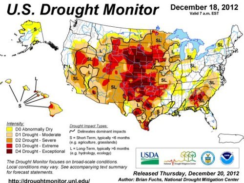
On Wednesday, near Amarillo, Texas, as the front came through it was accompanied with very strong winds (gusting to 80km/h) which managed to stir up a large dust storm. This dust storm was caused in part by the severe winds but also the severe drought currently occurring in the Southern Plains, including Amarillo, where the dirt is loose and can easily be picked up. The dust storm went through Interstate 27 producing near zero visibility and triggered a 23 vehicle pile-up.
By Saturday the trough will have moved off to Atlantic Canada, much of the US Midwest and Plains will experience below-normal temperatures as arctic air floods in from the Canadian Prairies.

Drought

Significant drought throughout the US Plains, both long-term and short-term. (Source: Drought Monitor, NDMC)

We again wish you happy holidays and all the best in the New Year!

Elsewhere in Weather News: December 15th, 2012

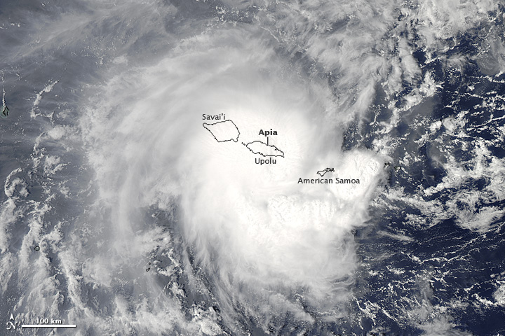
Tropical cyclone Evan struck the Samoan Islands on December 13, bringing strong winds and heavy rain to the area.

NASA's Aqua satellite captured this image of Evan as it struck Samoa

NASA’s Aqua satellite captured this image of Evan as it struck Samoa (Source: http://earthobservatory.nasa.gov/NaturalHazards/view.php?id=79989&src=nha)

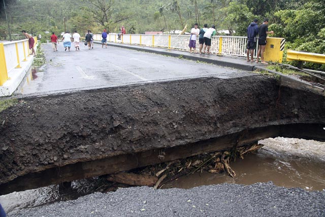
Evan was a category 1 cyclone when it struck the Samoan Islands region on Thursday, with maximum sustained winds of 144km/h. The storm came onshore near Apia, the capital of Samoa, and the country’s largest city (population 37,708). The cyclone destroyed buildings, ripped up trees, and took down phone, internet, and electricity services across Samoa. In addition, the heavy rain generated by Evan caused widespread flooding. The death toll from Evan is at least 2, with the cyclone being called the worst in many years by local residents.

People walk over a destroyed bridge in Samoa's capital Apia, Friday, Dec. 14, 2012

People walk over a destroyed bridge in Samoa’s capital Apia, Friday, Dec. 14, 2012 (Source: http://www.wunderground.com/blog/JeffMasters/article.html?entrynum=2311)

Evan has taken an unusual track so far, first moving eastward toward Samoa, then making a 180 degree turn over the islands, with its track now taking it westward toward Figi. Evan is currently intensifying, with maximum sustained winds presently at 185km/h. That is high enough to make it a category 3 cyclone on the Saffir-Simpson scale. Current forecasts suggest that the cyclone could approach category 5 status (winds >252km/h) this weekend, before hopefully weakening somewhat prior to affecting Figi. Despite its expected weakening trend ahead of hitting Figi, Evan could become a major disaster for the country, with the country’s leader Commodore Frank Bainimarama’s quoted as saying the following “Fellow Fijians I cannot stress how serious this is, every Fijian will be affected”. Figi is a small country consisting of 332 islands with a population of approximately 850,000.

Elsewhere in Weather News: December 8th, 2012

Typhoon Bopha Makes Landfall

(Follow-up to last week’s EIWN article “Typhoon Bopha Takes Aim at the Philippines”)

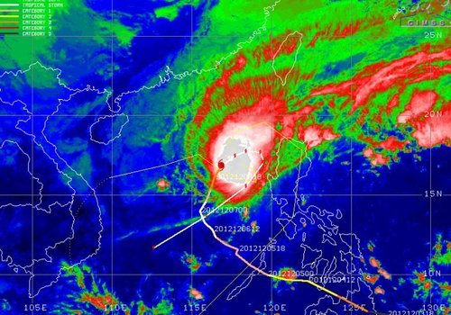
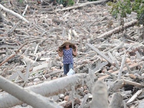
Typhoon Bopha made landfall on Monday, December 3rd, on the southernmost island of the Philippines. The typhoon was classified as a dangerous category five, where winds exceeded 250km/h. As expected with category five typhoons, the devastation and destruction caused extensive damage to infrastructure and crops; one fourth of the banana crops in the region were destroyed. As of Friday, December7th, it was reported that over 500 people had died as a result of the storm, and about 350 were still missing. Rescue workers are working feverishly, looking for survivors assumed to be trapped in their houses because of mudslides, or gold miners trapped in mines. In total, Bopha displaced about 250,000 Philippine residents who mostly took shelter in public buildings to ride out the storm. The Red Cross is providing funds and food to the ravaged country. Bopha appears to be the strongest, southernmost typhoon on record, to have ever affected this region of the Philippines.

Bopha

Infra-red satellite image of Bopha on Friday evening. It does not have a distinct eye and is showing signs of weakening. Forecast track is in white. (Source: CIMSS)

After Bopha made landfall in the Philippines, it emerged into the South China Sea and has re-strengthened to a category three hurricane with a well-defined eye. Its track has taken a northerly direction which was followed by a north-easterly track, which means its outer bands will affect the north-west islands of the Philippines later this weekend. Bopha will continue its somewhat circular track and is predicted to eventually head out in a south-westerly manner towards Vietnam next week. There is a lot of uncertainty as to what will happen after that, but there are some signs that show the storm will weaken off to a tropical depression.

Damage

Incredible damage in New Bataan, a southern Philippine city. (Source: AFP)

In other news, New Zealand experienced its deadliest tornado on record this past week where an EF-2 struck a suburb of Auckland and killed three people. It’s not a common sight to see such a strong tornado in Auckland but the conditions on December 6th greatly contributed to this, as warm, humid air, fueled severe thunderstorms in that area.

Short collection of videos of what it was like being inside the New Zealand Tornado. (Source: AP)