Elsewhere in Weather News: January 10th, 2015

Bushfires Rage across Southern Australia

Dangerous wildfires flared up in the tinder-dry Adelaide region of Southern Australia early this past week, forcing residents to evacuate their homes.

It is not known what started the large bushfires, but weather conditions were the primary factor as to why the wildfires were able to spread so quickly. Long-term drought which has reached severe levels in the region was the first cause for concern that bushfires were possible. This past week’s summer-like weather was what caused the risk to turn into reality as temperatures rose anywhere between the mid-30s to as high as 42.5°C in the region. These temperatures combined with strong, dry (northerly) winds blowing from central Australia was all that was needed to fuel the fires. In total, a few thousand people had to be evacuated and about 40 houses and 12,500 hectares were lost from the bushfires even though nearly 2,000 firefighters battled the flames. The good news is that no severe injuries were reported and firefighters were able to save nearly 1,000 houses in the region.
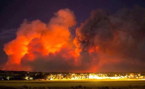
Picture taken last Sunday outside Adelaide of the bushfires. (Source: Matteo Barr // @Matteobarr)

Since mid-week fires have been under control, mainly due to more favourable weather conditions. A trough of low pressure brought both rainfall and cooler temperatures. The bushfire season is typically most severe from December to March in Southern Australia as temperatures soar and rainfall is scarce (January average of 25mm). Weather in the Adelaide region looks to remain fairly tame as the trough of low pressure lingers and brings overcast skies with occasional showers and cooler temperatures.
Elsewhere in Weather News: December 20th, 2014

Snow Squalls Paralyze Several Japanese Prefectures

This week’s Elsewhere in Weather News focuses on western side of the Japanese islands of Hokkaido and Honshu which have seen significant amounts of snow from a snowstorm that hit midweek.

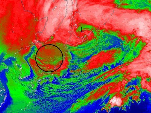
An area of low pressure which was moving northeast along Japan’s west coast quickly deepened to a 949mb low and whipped Japanese islands with winds of 60 to 100km/h. These winds, combined with widespread amounts of 20-30mm of rain ahead of the system. By the time the low reached the northern islands of Japan, strong northwesterlies kicked in over Japan’s main island of Honshu. Cold Siberian air infiltrated in over the Sea of Japan behind the low which stalled out, creating prime conditions that would sustain the development of snow squalls for a long period of time.

IR Satellite image of the mature low pressure system over northern Japan with circled area showing snow squalls forming over the Sea of Japan.

Snow squalls occur when cold air moves over a warm body of water, creating an unstable temperature profile. With the instability in place, snow squalls were able to from over the Sea of Japan and make their way to the western side of Honshu. Orography – the effect that terrain has in creating localized impacts on the weather – also played a role in providing additional lift which resulted in higher accumulations. The storm prompted blizzard warnings to be issued across 11 prefectures in western Honshu and Hokkaido.

These are the areas that saw the highest snowfall amounts recorded – accumulations generally ranged from 50cm to 120cm, but locally higher amounts were recorded near Niigata, Japan, up to 200cm. The storm caused 19 fatalities and forced cancellations of 600 flights across Japan.

Mountainous terrain located to the southeast of Niigata enhanced the snowfall amounts in the region.
Last week, another storm of similar strength brought significant snow to parts of Honshu as well as the northern island of Hokkaido. The forecast looks to favour more snow squalls as a similar setup to what was seen this past week – a strong low will be located near the northern island of Hokkaido and will draw in more cold Siberian air over the Sea of Japan.

Elsewhere in Weather News: December 13th, 2014

West Coast Hit With Strong Winds, Heavy Rains

The West Coast of North America has been subject to several systems after coming onshore in the past couple weeks, bringing with them heavy rains and strong winds which has led to flooding. Once again, the culprit for the moisture-laden systems in this region has been the atmospheric river. This atmospheric river is a term used for streams of moisture typically originating in the tropics, which head Poleward. Eventually the water precipitates out – it is often enhanced along the west coast due to orographic precipitation, leading to flooding.

Higher PW values streaming from the tropics to the Californian coast are associated with the atmospheric river. (Source: CIMMS)

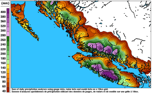
Earlier this week, the BC coast was hardest hit where over 400mm fell on parts of Vancouver Island in 6 days. Flood watches were issued as towns on the Island watched waters rise. The towns of Courtenay and Port Alberni were soaked with over 150mm by Wednesday – some residents were forced to evacuate their homes due to the rising waters. Strong winds were also a problem; gusts over 100km/h were recorded across the coast, even in large cities such as Portland, OR. These winds knocked out power to roughly 75,000 residents in BC alone. In addition to the wind and rain, landslides also became of concern in Southern California. Saturated grounds led to a large slide in Camarillo Springs, CA, which affected over a dozen houses.

Estimated rainfall along the BC coast from December 4 to the 10th. (Source: Environment Canada)
Estimated rainfall along the BC coast from December 4 to 10. (Source: Environment Canada)

The system even brought a weak EF-0 tornado which was spun-up in one of the stronger rain bands that came onshore. The tornado passed through a small area in southern Los Angeles yesterday morning and stripped roofs of their tiles – no one was injured thankfully. Reports of 60-100mm were common along the Californian coast, but localized amounts of 200mm or higher did occur. The highest precipitation report as of Friday came from an area in the northern Sierra Nevada Mountains where 450mm of precipitation fell; the amounts here were enhanced by orography.

Unfortunately models are showing another system impacting most of the West Coast early next week, not leaving much time for things to dry out.

Elsewhere in Weather News: December 6th, 2014

Super Typhoon Hagupit Heads towards the Philippines

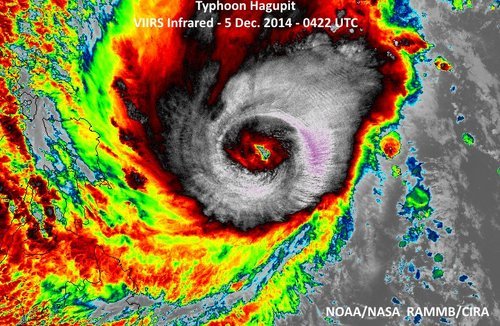
The Philippines are bracing for a very strong typhoon that is expected to make landfall this weekend. Hagupit, which was formerly known as a super typhoon (with winds exceeding 240km/h) has lowered in intensity but is still considered dangerous. The slight weakening was due to an eye wall replacement that took place. As of Friday afternoon, the typhoon was located in the West Pacific and heading west towards the central islands as well as the main islands where Manila is located.

This region has seen numerous strong typhoons in the last five years including super typhoon Haiyan, which made landfall in the Philippines 13 months ago just south of where Hagupit is expected to make landfall.

Hagupit looking more ragged as it approaches the Philippines after the eye wall replacement, however the bigger eye signifies a larger wind field. (Source: NOAA)

Yesterday, Hagupit had already begun lashing the islands with its outer rain bands. Evacuations were underway this past week where around 500,000 people have already been evacuated from areas most at risk including along small coastal fishing villages and in unsafe structures. The typhoon is expected to make landfall tonight near Sorsogon City, and will likely reach a high end category three or low end category four equivalent storm, bearing sustained winds of around 200km/h. Storm surges are sure to be a problem, especially along the front right quadrant of the typhoon, where surges could exceed 10 feet. Rainfall will also be of concern since Hagupit is fairly slow moving and will be able to drop copious amounts of rain. It is expected that the hardest hit areas, around where Hagupit makes landfall, could see around 500mm of rainfall.

After Hagupit emerges back over waters, the waters of the South China Sea, it is unclear as to where it will go and what its strength will be. A few of the forecast models show it holding together and continuing straight west with at least tropical storm force winds but sea-surface temperatures are not ideal for intensification in the region.