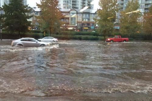
Elsewhere in Weather News: November 29th, 2014

Widespread Floods Affect Southern France

A low pressure system advecting plenty of moisture Poleward from the Mediterranean Sea was in place over south-central France on Monday making for a good setup of long lasting heavy rains. The rains, enhanced by scattered thunderstorms prompted Météo France to issue various warnings, from strong wind warnings to severe thunderstorm warnings in addition to the rainfall warnings. A few areas along France’s southern coast were particularly hard hit with rainfall totals between 180-210mm in six hours on Monday. In addition to that another general 40-50mm (some amounts higher locally) fell as the system was moving off on Tuesday. On Wednesday, another low pressure system quickly moved into the region, again bringing with it rain and more storms. There was also a report of a weak tornado accompanying the one of the storms.

With already saturated soils from earlier in the week, conditions were primed for overland flooding as the second system moved in. Helicopters and rescue workers were hard at work towards the end of this week as people got trapped in their vehicles and houses from the flooding in southeastern France. There were five deaths related to the flooding events and 6,000 households were without power. The damage from the unconfirmed tornado comprised of roofs blown off and trees uprooted.
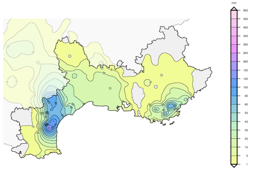
Precipitation map (in millimeters) of the rainfall in Southern France on Monday only. (Source: Météo France)

Unfortunately the soggy weather is expected to stick around the region this weekend. The upper-level cutoff low located over Southern Spain will drift ever so slowly to the east but will bring with it more showers and rain to southern France.

In other news, a supercell hit Brisbane, Australia this past week and knocked out power to 90,000 residents. The storm brought just about everything with it; golf ball size hail, strong winds and flash flooding – damages are in the hundreds of millions.
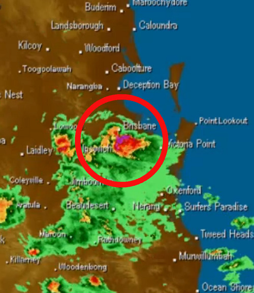
Radar image at the time the supercell was passing over Brisbane. (Source: BoM)

Elsewhere in Weather News: November 15th, 2014

More Flooding Hits Italy

Italy has seen its fair share of rainfall this past week, especially in the northern tier of the country including the city of Milan. Trouble started off in early November when a system originating from the Mediterranean Sea brought abnormal amounts of moisture into the region, producing heavy rainfall over a sizeable portion of Italy. This system, associated with a slow moving negatively tilted trough, dug down into southwestern Europe and triggered isolated thunderstorms and widespread rain. The system dumped copious amounts of rainfall – over 100mm fell in northern parts of Italy. With already saturated grounds from previous events in the past few weeks, this meant trouble for some villages.

Milan and surrounding areas saw the worst of the flooding. Subway systems were inundated with water, streets were flooded with over a foot of water and schools were forced to close. Two rivers in the region, the Seveso and Lambro, overflowed their banks and contributed to the flooding. The flooding is responsible for five deaths and estimated damages in excess of 100 million dollars.

Significant repairs will have to be done to this central Milan canal wall and road which collapsed due to the saturated ground below that gave way. (Source: @SimoneEneaRicco)

Northern Italy will remain soggy over the weekend, with another 10-20mm expected due to the same slow moving trough which continues to linger. Throughout November Milan usually sees about 100mm of precipitation, but just half-way through they have already surpassed it.

By the beginning of next week there’s a good chance that things will start to clear up as a weak ridge builds in.

Elsewhere in Weather News: November 8th, 2014

Super Typhoon Nuri Transitions into Strong Extratropical Storm

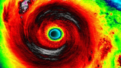
The Western Pacific continued to be active this past week, spinning up yet another violent storm, which thankfully remained at sea and did not impact land. Nuri formed late last week west of Guam and slowly drifted west-northwest. It organized itself as conditions became ideal for strengthening of the typhoon: sea surface temperatures were very warm and wind shear was low. Nuri became a super typhoon last weekend as it deepened to a central pressure of 910mb and brought estimated sustained winds of 285km/h – similar conditions to what super typhoon Vongfong had at its peak this past October. Up to date, these two are tied for the strongest tropical storm of 2014. Nuri quickly curved Poleward before reaching Japan, sparing the Japanese islands from the storm.

IR satellite image of Nuri as it held super typhoon strength this past Sunday/Monday. (Source: Soumi NPP VIIRS)

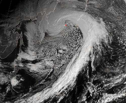
Nuri did not end there, however. As it got captured by the polar jet stream, it transitioned into an extratropical storm. Extratropical storms are the low pressure systems that we see across the mid-latitudes, including here in Manitoba. They have significant differences from their tropical brethren, the most significant being that extratropical storms have warm and cold fronts that generate energy for the storm, as opposed to tropical systems that have generally uniform temperature. As the remnants of Nuri transitioned into the Polar Jet they strengthened once again, aided by a strong temperature gradient aloft.[1] Projected wave heights on the Bering Sea neared 50 feet as the storm “bombed” out[2] on Friday to a minimum pressure of 927mb. Extremely strong winds were recorded on the Aleutian Islands, where gusts exceeded 150km/h.

Satellite picture of the remnants of Nuri as an extratropical storm on Friday.

The remnants of Nuri are expected to continue moving towards Alaska but weaken significantly by the time they reach the Alaskan shores, as the low pressure system enters its weakening phase.

Alaskan Bomb Results in Arctic Outbreak over Central & Eastern North America

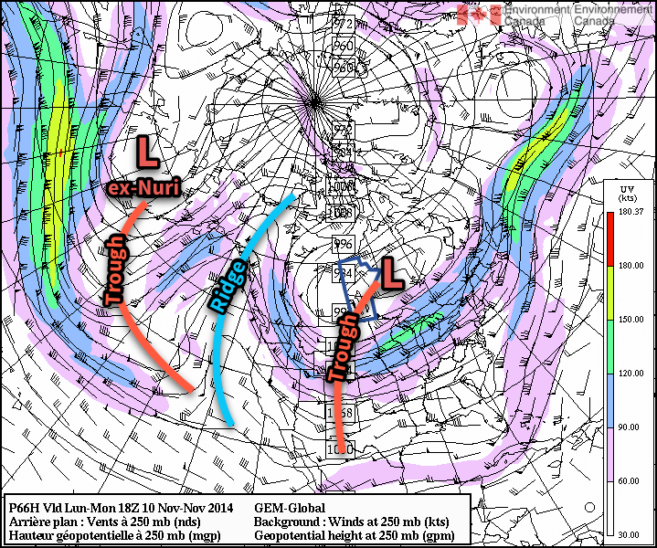
The intense storm over the Aleutian Islands is also indirectly responsible for the outbreak of cold air expected in the coming week over much of North America. As the system intensifies over the Aleutian islands, a strong upper-level ridge will build over the west coast of North America which will cause a resultant upper level trough to deepen over the remainder of the continent.

The GDPS shows prominent ridging over the west coast of North America, resulting in a deep upper-level trough over central & eastern North America.

The deep upper-level trough will allow the cold air that’s been bottled up in the Arctic to spill southwards, resulting in well below seasonal temperatures across a significant portion of Eastern North America. The developing upper-level pattern is a fairly stable configuration for the flow, so no significant changes will likely occur in the next week or two other than gradual moderation.


  1. The strong temperature gradient was easily evident by a very strong jet streak of over 130 knots – that’s over 240km/h – at 500mb!  ↩
  2. A system has “bombed” when its central pressure drops 24mb or more in 24 hours.  ↩

Elsewhere in Weather News: October 26th, 2014

Vancouver Sees Significant Rain Event

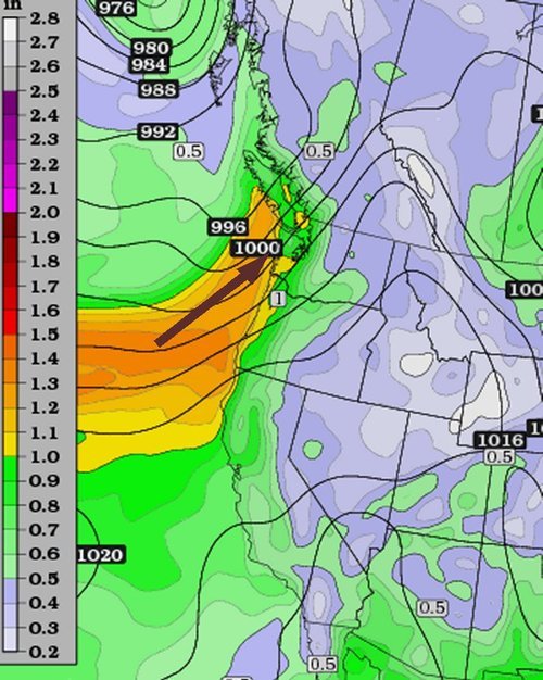
The city of Vancouver has seen its fair share of rainfall this past week, causing flooding problems throughout the metro. What was to blame for this event was an atmospheric river that came onshore the BC Coast, aided by a large upper level trough off the West Coast on Wednesday. Atmospheric rivers are narrow plumes of significant moisture which originate from the subtropics and flow from the southwest onto the shores of the west coast. On Wednesday morning fairly high PWAT[1]
values (>1”), a product of the atmospheric river, nosed into the Vancouver region which set the stage for the heavy rainfall event.

Atmospheric river making its way onto Vancouver island. (Source: Twisterdata)
Atmospheric river (high PWAT values) making its way onto Vancouver island. (Source: Twisterdata)

The rainfall started early Wednesday morning for Vancouver, including a thunderstorm that went through the city around 7am dropping heavy rain. With already saturated soil from the rain earlier in the week, flooding problems ensued. Metro Vancouver saw anywhere between 20-35mm, and pockets of locally higher amounts Wednesday. This event comes a day after the same system offshore brought very strong winds (gusts >100km/h) to Vancouver Island as well as downing power lines and snapping trees in metro Vancouver. It was reported that Tuesday night a total of 80,000 people in southern BC were without power at some time.

Flooding in Port Moody, just east of Vancouver, on Wednesday. (Source: Port Moody Fire Rescue)

As this mid-week system departs, it makes way for the next system upcoming system this weekend. This will be yet another fairly strong system to impact the west coast, bringing with it more heavy rains and strong northwest winds. Unfortunately, unsettled weather is expected to last for the Vancouver region into next week.


  1. PWAT stands for precipitable water, a measure of the amount of water contained in a column of air.  ↩