Staying Above Normal; Chance of Snow Midweek

This week will remain seasonably warm, although not quite as warm as last week. There will also be another chance of snow by the middle of the week as a low pressure system pushes up from the south.

Today will be seasonably warm, but mainly cloudy. We’ll be under a breezy north-easterly flow as a strong surface high sits off to our north-east. Temperatures will sit just below the freezing mark with little change throughout the day.

Tomorrow will be mainly cloudy once again, but this time there will be a slight chance of flurries. Any snow that does fall will not accumulate to much. Temperatures will sit in the mid minus single digits with a light easterly wind.
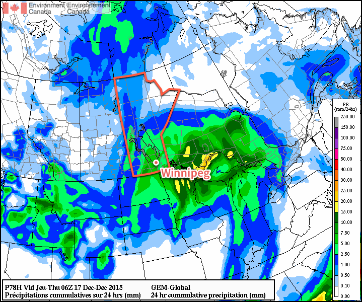
GDPS 24hr QPF valid 06Z December 17, 2015
Just one guess of the snow swath expected with a low pressure system passing by on Wednesday.

A stronger low pressure system is currently forecast to affect southern Manitoba on Wednesday. This will be a Colorado Low type system, which is expected to mainly affect areas to our south, but may also bring light to moderate snowfall to parts of southern Manitoba. At this point it appears that areas along the US and Ontario borders will see the most snow, but it’s too early to speculate on possible accumulations. Stay tuned for more updates.

Long Range

The long range forecast suggests that we’ll continue to slide closer to seasonal temperatures in the short to medium term. That means high temperatures near -10C and low temperatures near -20C. However, ensemble guidance continues to hint at high probabilities of above-normal weather as we move toward Christmas, so any prolonged cold snaps appear quite unlikely through the end of December.
Where’s Winter?

Winter will remain absent this week as temperatures remain well above seasonal and our meager snowpack continues to melt.

Today will remain well above normal for early December, as high temperatures across all of southern Manitoba remain near or slightly above zero. In the Winnipeg region, high temperatures are expected to creep just above the freezing mark, although skies are expected to remain mainly cloudy throughout the day. Winds will be breezy from the south at 20-30km/h.

Tuesday will once again be seasonably mild, with high temperatures near or just above freezing. A weak low pressure system will pass through or just south of southern Manitoba, potentially bringing some light rain or snow to some areas. Given the warm temperature profile, any snow that falls is unlikely to accumulate to much. On the other hand, if we see a bit of rain it will only aid the snowmelt.

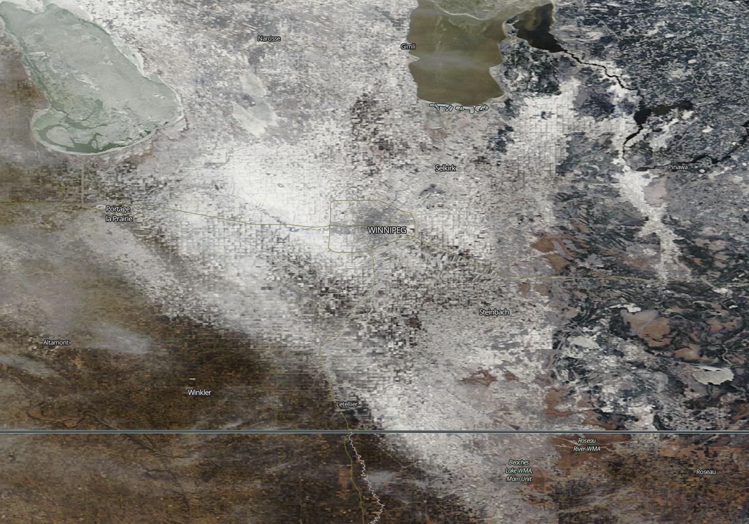
MODIS (Aqua) True Colour Satellite for December 6, 2015
Yesterday’s MODIS imagery clearly shows the diminishing snow pack over the Red River Valley.

Wednesday will see temperatures climb above freezing in southern Manitoba, perhaps well above zero in snow-free areas. In the northern Red River Valley, high temperatures will only be a few degrees above freezing. Winds will be breezy from the south at 20-30km/h.

Long Range

Models continue to show above-seasonal weather for the foreseeable future. However, after this week temperatures may not be quite as warm as they’ve been of late. The average high temperature at this time of year is -8C and the average low is -18C, so don’t expect temperatures to drop much below those values through the first half of December – particularly if we remain generally snow-free. The lack of snow reduces the reflectivity of the surface, allowing more sunlight to be absorbed, generating more heat in the lower atmosphere. So long as we don’t have snow on the ground over much of the southern Prairies, we will maintain a built-in bias toward warm conditions.

Pleasant Week Ahead

Pleasant weather is on tap this week as we see a fair amount of sunshine and above-seasonal temperatures.

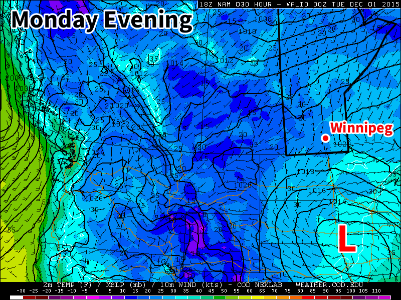
A low pressure system will sit just south of Manitoba early in the week

Monday

Today will see mainly sunny skies and mild temperatures. The daytime high will be just below zero with light southerly winds. A strong low pressure system will be bringing precipitation to portions of the Dakotas and Minnesota early this week, so you’ll want to check the forecast if you’re heading south.

Tuesday

Tuesday will see much the same weather as Monday. Skies are expected to remain mainly sunny, with high temperatures in the mid single digits. If the system to the south pushes a bit further north we may see more cloud cover, but that is not expected to be the case at this point. Winds will be north or north-westerly at 20 km/h.

Wednesday

Wednesday will once again feature mainly sunny skies and mild temperatures. Temperatures will be just below zero, with breezy southerly winds at 20 km/h.

Long Range

The long range forecast continues to strongly suggest above-normal weather for the first half of December. The current weather pattern over North America is very typical of El Nino, with warm conditions across the western half of Canada and an active storm track across the southern US. Expect this pattern to continue as we move further into winter.

More Snow on the Way

More snow is on the way this week, probably not what you were hoping to hear (at least most of you).

Monday

Today will feature mainly cloudy skies and more snow! There will be a chance of flurries throughout the day as we remain under a cloud deck with some low-level instability. Accumulations of new snow aren’t expected to be large, but will not be welcome by most nonetheless. Luckily, temperatures will remain near 0C, allowing snow to easily melt off treated surfaces. Winds will also be relatively light, preventing the white-out conditions we experienced last week.

Tuesday

We’ll likely see a break from the snow on Tuesday morning, but more is on the way later on Tuesday. A stronger low pressure system will be pushing into southern Manitoba from the west, bringing more accumulating snow by later on Tuesday.

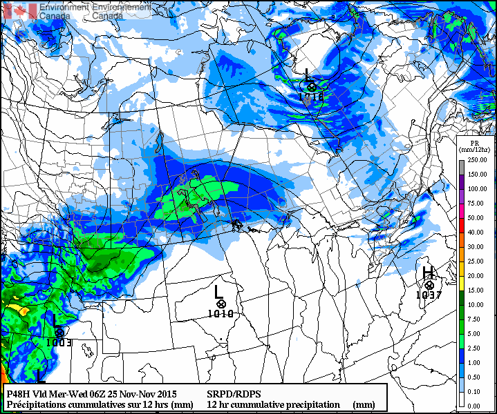
RDPS 12hr. QPF valid 06Z Wednesday November 25, 2015
A large swath of snow is expected to move through southern Manitoba on Tuesday.

At this point accumulations looks to be around 5ish centimetres, but that number may go up or down depending on the eventual track of the system. Winds will be easterly at 30km/h gusting to 50km/h, leading to blowing and drifting snow out on the highways. However, temperatures will still be hovering near 0C, again helping to prevent ice from forming on treated roadways.

Wednesday

Snow will taper off on Wednesday morning, followed be clearing skies through the day. Unfortunately, a cold front will push through southern Manitoba on Wednesday morning, ushering in gusty north winds and a chillier air mass. Wind speeds are expected to increase to 40km/h gusting to 60km/h, allowing for more blowing and drifting snow. Temperatures will fall throughout the day as this colder air mass floods in, with temperatures dropping to the minus double digits by evening.

Long Range

The long range forecast continues to show generally above-seasonal weather for southern Manitoba as we push further toward winter (remember it’s not technically “winter” yet). This November is running 6.4C above normal, although that is going to change with the colder pattern that we’re currently in. Unfortunately, we live in Manitoba, so even “warm” winter weather is never really that warm, but hopefully we’ll avoid the extreme cold that has plagued us frequently the last few winters.