Investors Group Field - Canada vs. USA - 2014

Beautiful Start to The Week For The First 2015 FIFA World Cup Game in Winnipeg

The first half of this week will bring generally pleasant summer weather to Winnipeg & the Red River Valley. Some showers or thunderstorms may be possible on Monday and/or Tuesday, but mainly south and east of Winnipeg.

Monday

Today will be a beautiful day for the first 2015 FIFA Women’s World Cup game played here in Winnipeg. Skies will be mainly sunny and high temperatures will climb into the upper twenties. Winds will be relatively light from the north-west at 20 km/h or lower. There may be a few passing showers or very weak thunderstorms south and east of Winnipeg, but nothing of particular significance. Overall it will be a very nice day!

Tuesday

Tuesday will see mainly sunny skies prevail once again, with temperatures in the mid twenties over much of southern Manitoba. Winds will be fairly gusty from the north-west at 30km/h gusting up to 50km/h. Similar to Monday, there will be a risk of thunderstorms south and east of Winnipeg. The risk for storms may shift in later forecasts, but presently it appears that eastern Manitoba could see some marginally severe storms, with perhaps some severe hail. We will provide another update if this threat is expected to materialize.

Wednesday

Benign weather looks to return for Wednesday with mainly sunny skies and no precipitation expected. Temperatures will be in the low twenties and winds will be from the north-west at 20-30km/h.

Long Range

Long range models suggest that generally normal to above-normal weather is expected for the next week or two. Frequent passing weather system will bring unsettled conditions from time to time, with a risk of thunderstorms (generally non-severe). We are certainly not in a full-blown summer pattern just yet, but average temperatures continue to warm!

Unsettled Start to the Week

The first part of this week will see unsettled weather as a strong low pressure system passes to our south. This system will likely result in moderate rainfall and a risk of thunderstorms over southern Manitoba on Tuesday.

Monday

Today looks to be mainly cloudy ahead of an approaching low pressure system. There may be a few passing showers throughout the day, but no major precipitation is expected. High temperatures are expected to reach the low twenties with gusty south winds.

Tuesday

Tuesday looks quite unsettled as we sit north of a fairly strong low pressure system over the Dakotas. A warm front will likely be located over northern North Dakota, allowing for warm and potentially stormy weather just to our south. In southern Manitoba, we will remain stuck in a cool easterly flow north of the warm front. As a result of our position relative to the warm front we likely see moderate rainfall during the day with a chance of embedded thunderstorms.

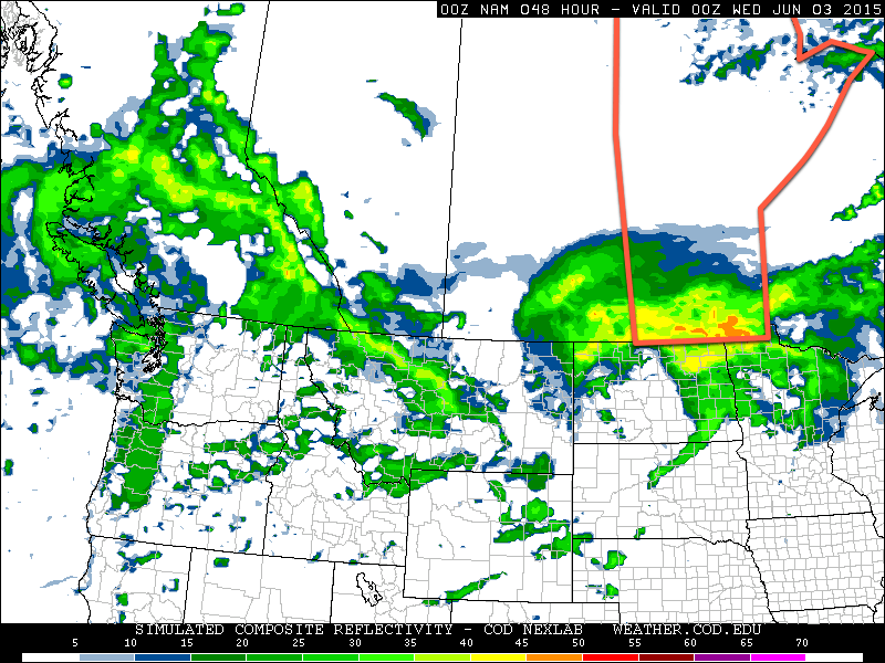
NAM Simulated RADAR Reflectivity
The simulated RADAR reflectivity from the NAM forecast for Tuesday afternoon shows a large area of rainfall moving over Southern Manitoba.

Should the warm front move further north than expected, our risk of thunderstorms will be higher, but at this time that does not look probable. Total rainfall amounts in southern Manitoba could be in the 15-35 mm range, although it is difficult to predict this sort of system ahead of time. Higher rainfall amounts are certainly possible on a localized basis due to isolated thunderstorm activity.

Wednesday

Wednesday looks cool and cloudy as Tuesday’s system departs. We my see a few showers during the day, but in general not much precipitation is expected. The wind will be from the north at around 30 km/h.

Long Range

The long range forecast suggests we’ll see generally normal to above-normal weather through the middle of June. Numerous weak to moderate weather systems are expected to traverse the region over the next while, meaning our weather will continue to feature unsettled patches, before we return to more favourable conditions.

More Warmth Ahead This Week

The weather this week will continue from where the weekend left off as warm and mainly sunny conditions prevail. Temperatures will remain in the upper twenties, before dropping off a bit mid-week.

Monday

Today will be mainly sunny, although some upper-level cloud may drift through southern Manitoba as a result of a large weather system to our south. Other than that, there isn’t much weather to discuss for today. Temperatures will climb into the upper twenties and winds will remain light.

Tuesday

Tuesday looks to remain quite warm, with temperatures once again reaching the upper twenties. During the afternoon it is expected that the atmosphere will destabilize a bit due to slightly higher humidity and daytime heating. This may result in the development of some showers and thunderstorms. Any storms that do develop will be weak with only very small hail and/or brief gusty winds being possible.

Wednesday

A cold front will pass through southern Manitoba on Wednesday morning, ushering in slightly cooler temperatures. Highs are expected to be in the low to mid twenties under mainly sunny skies. There may be some light showers associated with the passage of the cold front, but other than that no significant weather is expected.

Long Range

The long range forecast suggests we’ll generally stick with above-normal temperatures, although not necessarily as warm as it has been recently. Highs will more likely reside in the low to mid twenties, although the occasional jump into the upper twenties is certainly possible.

Chilly Start to the Week

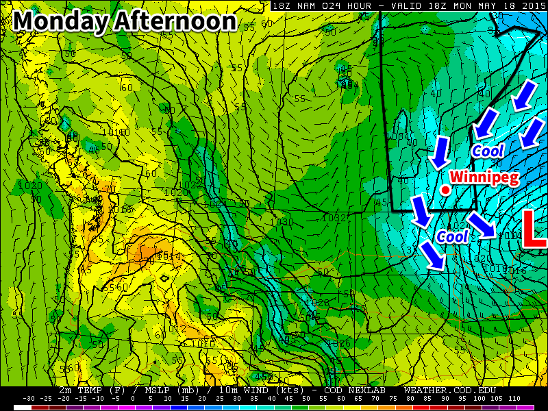
This week will start off on the cool side as a brisk northerly flow builds in behind this weekend’s Colorado Low. Temperatures on Monday will be downright chilly for mid-May.

Cool weather will dominate southern Manitoba on Monday

Monday

We’ll see skies gradually clear today as the system that brought us rain (and snow) this weekend departs. It will remain very chilly though, as temperatures barely climb into positive values. Daytime highs will only make it into the low to mid single digits, which should hopefully be enough to melt a good amount of the snow that fell. Winds will be northerly at 40 km/h gusting to 60 km/h, but will taper off throughout the day as the system pushes further off to the east.

Tuesday

Tuesday will remain on the cool side, but should be a fairly pleasant day (at least relative to the weekend!). High pressure will build into the region behind the weekend’s low pressure system, bringing much calmer conditions. High temperatures will climb into the teens under mainly sunny skies and light winds.

Wednesday

Wednesday will be quite nice as temperatures climb into the upper teens under mainly sunny skies. Winds will be relatively light and from the north-west, making for another pleasant day.

Long Range

The long range forecast shows conditions remaining slightly below normal through the end of the work-week. There are hints that we’ll see warmer conditions build in by the weekend, but it’s too early to say for sure. In general, models show us transitioning to a generally warmer pattern toward the end of the month, although there will still be some cooler days mixed in here and there.