Scary Cold

This week will start out scary cold, as it continues to feel more like January than early December.

Monday morning will be extremely cold in southern Manitoba

Monday

Monday
-20°C / → -20°C
Mainly Sunny

This morning will likely feature the coldest temperatures we’ve seen so far this winter. Temperatures will slowly climb toward minus twenty the day, but a gusty south wind will begin to develop as well. By the afternoon the wind will be 40km/h gusting to 60km/h, putting wind chill values in the mid to upper minus thirties. That gusty south wind will also generate patches of heavy blowing and drifting snow in open areas.

Tuesday

Tuesday
-12°C / -20°C
Mix of sun and cloud

Tuesday will be significantly nicer than Monday. Temperatures will be in the minus teens, but the wind will be light and from the west…just that fact alone will make it feel a lot warmer!

Wednesday

Wednesday
-12°C / -25°C
Mainly Sunny

Wednesday will feature much the same weather as Tuesday. Temperatures will once again be in the minus teens, but with a slightly stronger west wind. There may be a few flurries early on Wednesday morning, but nothing of great significance.

Long Range

Long range guidance suggests we’ll see less extreme conditions develop as we move into December. Models are hinting at an upper ridge building over the Prairies about a week or so into December. That doesn’t necessarily mean it will be warm, but conditions that are closer to normal, or perhaps even above-normal should become more prevalent.
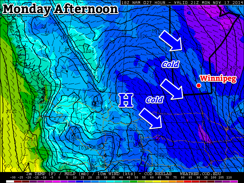
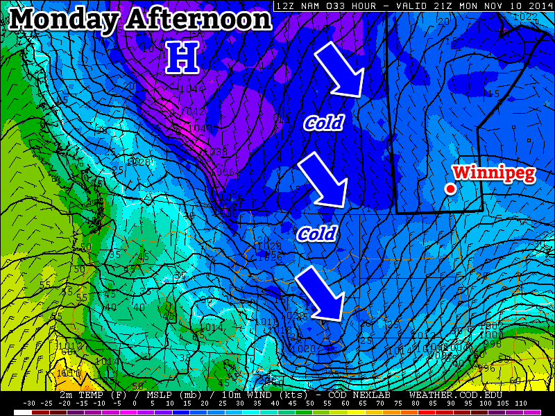
Mid-Winter Cold in November

This week will feature the coldest weather we’ve seen since last winter, just what you were hoping for I’m sure!

Monday

Monday
-12°C / -16°C
Clearing

Skies will clear on Monday morning, giving way to a sunny, but cold day. High temperatures will be in the minus teens with a brisk north-west wind. Watch out for slippery sections on the roads, as freezing drizzle and snow from yesterday will certainly still be an issue on untreated surfaces.

Tuesday

Tuesday
-9°C / -17°C
Mainly cloudy with chance of flurries

Tuesday will be one of the warmer days this week (if you can believe it). Temperatures will hover around the -10C mark with a chance of flurries throughout the day. The mainly cloudy skies will be partly responsible for the warmer conditions, trapping heat near the surface. Winds will be fairly light and from the north-west.

Wednesday

Wednesday
-18°C / -30°C
Mainly Sunny

Wednesday looks to be the coldest day since last winter as a strong surface high descends into southern Manitoba. High temperatures will barely crack the minus teens and lows on Wednesday night could approach -30C. A brisk northerly wind will add a decent wind chill factor as well, making it feel even colder, if that’s possible!

Long Range

The long range forecast looks awful, so there’s barely any point even talking about it. Temperatures look to remain below seasonal for the foreseeable future…hopefully you’re ready for winter, because it’s here!

Remaining Cold

This week will remain cold as arctic air continues to spill down from the north.

A northwesterly flow will continue to bring cold weather to southern Manitoba on Monday

Monday

Monday
-8°C / -14°C
Mix of sun and cloud with chance of flurries

Today will be cold and breezy. Temperatures in the morning will be in the minus teens, rising into the minus single digits by afternoon. Skies will be a mix of sun and cloud with chance of light flurries. The wind will be from the north-west at 20-30km/h.

Tuesday

Tuesday
-7°C / -10°C
Mix of sun and cloud with chance of flurries

Tuesday will be slightly warmer than Monday, but not by much. High temperatures will once again be in the minus single digits, once again under a mix of sun and cloud. There will also be a chance of light flurries throughout the day. Winds will be breezy and from the south.

Wednesday

Wednesday
-9°C / -18°C
Mainly cloudy with flurries

Wednesday looks to be a fairly miserable day. High temperatures will be near the -10C mark, with a gusty north-west wind and flurries. This means blowing snow is likely in open areas, similar to the conditions experienced on Sunday. Winds speeds of 40km/h gusting to 60km/h are expected.

Long Range

The long range forecast calls for continued cold weather. Weather models suggest that we’ll see below-normal weather persist for at least another week. Unfortunately, it looks like winter is here to stay, like it or not.

First Taste of Winter

This week will feature our first taste of winter as a cold arctic air mass descends on southern Manitoba.

Cold weather will descend on southern Manitoba this week

Monday

Monday
-5°C / -8°C
Mainly cloudy with chance of flurries

Today will be one of the coldest days we’ve seen so far this fall. High temperatures will stay on the minus side of zero with the possibility of light flurries throughout the day. There will be a breezy north wind as well, but overall it shouldn’t be too unpleasant.

Tuesday

Tuesday
-4°C / -5°C
Mainly cloudy with chance of flurries

Tuesday will feature weather that is very similar to that experienced on Monday. High temperatures will once again remain in the minus single digits with a chance of flurries. The wind will once again be from the north, at 20-30km/h.

Wednesday

Wednesday
-3°C / -6°C
Flurries

Sub-freezing weather will continue on Wednesday, with high temperatures in the minus single digits yet again. Flurries will be likely throughout the day, and some light accumulation may even occur. The wind will be gusty and from the north or north-west.

Long Range

The long range forecast suggests we will see wintry conditions continue for the foreseeable future. Thankfully, no major snowfall events are currently in the forecast. Snow cover dramatically affects our temperature regime, so the longer we can avoid the white stuff the longer we will avoid really cold conditions!