A Return to Calmer Weather

After a weekend marked by severe storms, heavy rain, and strong winds, we should see a return to calmer weather this week. Temperatures will be near seasonal values with more sun than cloud.

This Week

Drier weather is on tap today, as a high pressure system builds into the region. This high should bring mainly sunny skies, offering a much needed break from the wet weather of the past week. Temperatures should climb into the low twenties with breezy winds out of the north at 20 km/h.

Tuesday should see temperatures climb into the mid twenties as some warmer air begins to filter in from the west. With slightly higher humidity expected to build in as well, we could also see some isolated thunderstorms develop. These storms are expected to be quite localized in nature, so not everyone will be affected. Those affected could unfortunately see more rainfall and perhaps a bit of small hail, but nothing too serious. Outside of the storms winds will be fairly light with mainly sunny skies.

We should see continued sunshine on Wednesday with temperatures once again in the mid twenties. Winds will be a bit stronger than Tuesday, at 20 km/h gusting to 40 km/h out of the northwest.

Long Range

Long range models suggest we will generally see above seasonal weather as we move into July. However, it is less clear whether or not our weather pattern will be drier next month. Climatologically June is the wettest month of the year, with 90 mm being “normal”. So far this month the Winnipeg airport has received 91.4 mm, which is right around normal. However, many other parts of southern Manitoba have seen far more precipitation. For wetter areas a period of dry weather would be very much appreciated.
Drier Weather to Start the Week

This week will start out on a drier note after the heavy rains of the weekend left many parts of southern Manitoba in a very soggy state.

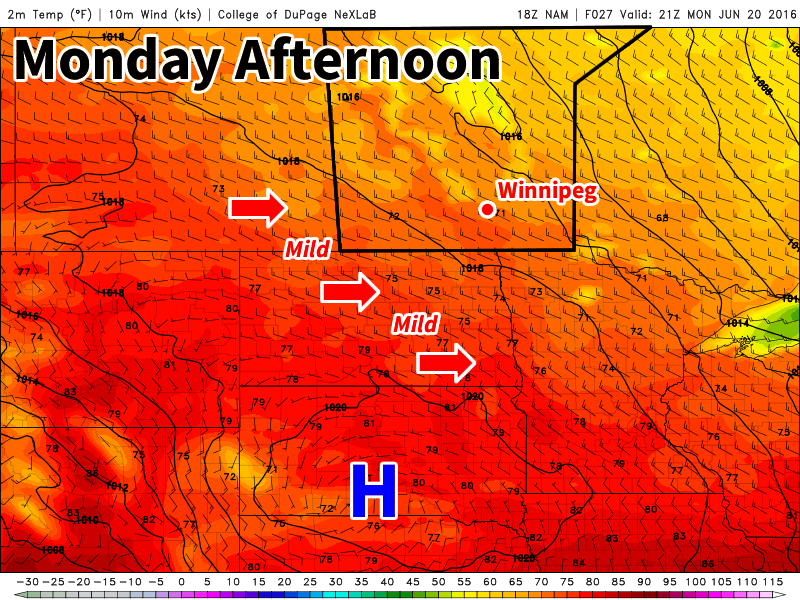
Mild and breezy weather is expected in southern Manitoba on Monday

This Week

Today will be mainly sunny with temperatures climbing into the low twenties. The sunshine will be welcomed by many in southern Manitoba as it will give a chance for many water logged areas to dry out. Winds will be northwesterly at 20-30 km/h.

Tuesday will feature much the same weather as today, with temperatures in the low twenties and mainly sunny skies. Winds will be a bit lighter however, making it an even better day.

Wednesday’s weather is the most uncertain of the early week period. Most models suggest southern Manitoba will see mainly sunny conditions with temperatures in the mid twenties. However, an area of precipitation is expected to pass to our south. Should the forecast shift that precipitation northward, we could see more rain. At this time that does not appear likely, but it is something to bear in mind.

Long Range

The long range forecast continues to show us in a generally above-seasonal pattern through the end of June. However, we are also forecast to remain near the storm track through month’s end, suggesting more wet weather may be on the way later this month. Forecasting weather in the long range can be quite difficult in summer, so unfortunately you’ll just have to take the conditions as they come to some extent.

Beautiful Start to the Week, but More Rain is Coming

This week will get off to a great start, with warm temperatures and sunny skies. However, more rain is on the way Tuesday night as the next low pressure system moves into the region.

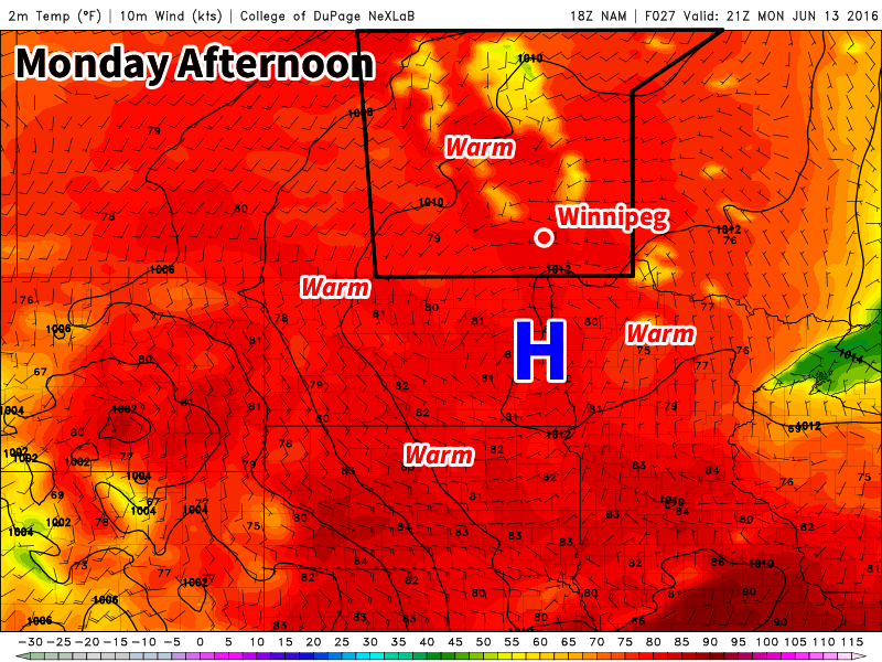
Warm weather is expected in southern Manitoba today

The Week

Today will be a great day in southern Manitoba. High temperatures in the mid to upper twenties are expected with sunny skies. Winds will be light from the west. Today may end up being one of the nicer days this week, so enjoy it!

Tuesday will see temperatures in the mid twenties, but with increasing cloudiness through the day as a low pressure system begins moving into the region. Winds will be breezy out of the south-east at 20 km/h gusting to 40 km/h ahead of this system. Rain is expected to move into southern Manitoba on Tuesday night with this next system.

Wednesday will see rain ending from the aforementioned low pressure system. At this potential rainfall accumulations remain uncertain, so check back tomorrow for more details. Once the rain ends skies will remain mainly cloudy with temperatures in the upper teens. Winds will be from the north at 20-30 km/h.

Long Range

The long range forecast shows warmer weather returning late this week. Models are also hinting at our next risk of thunderstorms developing on Thursday and/or Friday with the approach of an upper trough moving in from western North America. We’ll have more details about this risk later in the week. Besides the thunderstorm risk, long range models generally show above seasonal temperatures for the remainder of June, although some cooler stretches are likely to be interspersed with the warmer ones.

A Couple More Cool Days Before We Heat Up

We’ll have a couple days of cool weather before an upper ridge builds in, bringing hot & humid weather to southern Manitoba in the second half of the week. The arrival of the heat and humidity is also expected to bring our first significant risk of severe thunderstorms this year.

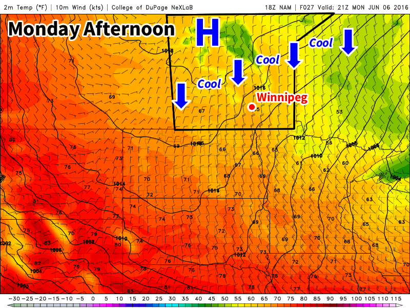
A cool northerly flow will be in place over southern Manitoba on Monday

This Week

Today will remain on the cool side as a surface high to our north-west pumps cool air into southern Manitoba. Some cloud cover is expected in southern Manitoba during the morning as an upper disturbance moves through, but skies should clear by the afternoon. Daytime highs will be in the upper teens with gusty north winds at 40 km/h gusting to 60 km/h.

Tuesday will remain cool as we remain under the influence of that surface high. Temperatures will once again be in the upper teens, although some areas in western Manitoba may reach the low twenties. Skies are expected to be mainly sunny and winds will be breezy from the north.

Warmer weather will begin to move into southern Manitoba on Wednesday as the surface high moves off to the east. A southerly flow will be in place over southern Manitoba, helping to bring warmer air into the region and push daytime highs into the mid twenties over the Red River Valley and the upper twenties over western Manitoba. There will likely be a risk of severe thunderstorms in eastern Saskatchewan on Wednesday and that may spill over into western Manitoba. Depending on how conditions develop, the thunderstorm risk may extend across all of southern Manitoba on Wednesday night as storms from Wednesday evening move east with time. A westerly steering flow and a strong southerly low-level jet would tend to favour easterly or south-easterly storm motions, which would help steer storms toward the Red River Valley during the overnight period. More details on Wednesday’s potential thunderstorm risk will be available as the week progresses.

Long Range

The long range forecast suggests a hot, but unsettled pattern, will be in place for southern Manitoba from late this week into the weekend. An upper ridge will be centred over southern Manitoba during this time period, but we are expected to remain at the top of this ridge, putting us along the storm track. The influx of warm, humid air due to the southerly flow in this ridge combined with the moderate to strong flow with the jet stream aloft should favour numerous thunderstorm chances during the Wednesday-Monday period. The nature of the thunderstorm threat remains quite unclear, but at least one or two severe events seems probable at this time. An upper trough is expected to approach either late this weekend or next week, which will push out this hot/humid air mass.