Elsewhere in Weather News: April 12, 2014

Cyclone Ita hit North Queensland last Friday, called one of the worst ever in the region.
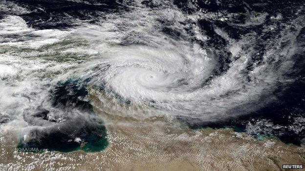
Visible satellite image of Cyclone Ita as it hit Far North Queensland

Cyclone Ita hit North Queensland, Australia as a category 3 storm on Friday into Saturday (local time), bringing strong winds and flooding rain to the region. Wind speeds higher than 120 km/h were reported near the small town of Cookstown, Australia and speeds near 160 km/h were reported at Cape Flattery. In addition, more than 125 mm of rain fell in Cookstown. However, the highest reported rainfall total was 311 mm in Bairds. Cyclone Ita hit the Soloman Islands before impacting Australia, causing 21 deaths there. The number of deaths, were there any, from Ita in Australia is not presently known. Luckily, the part of North Queensland hit by Ita is sparsely populated, helping to minimize the impact of the storm.

Cyclones are a common phenomenon in the waters surrounding Australia. Also called willy-willies by locals, cyclones are the same as hurricanes, except that they occur in the Pacific and Indian Oceans, rather than the Atlantic Ocean. The main requirements for cyclone formation are surface water temperatures of at least 27 degrees Celsius and weak vertical wind shear (the absence of a jet stream overhead). These conditions are most often met in the tropics, though cyclones and hurricanes have been known to impact areas at higher latitudes late in the summer and early in the fall.

Sources:
Elsewhere in Weather News: April 5th, 2014

Madagascar Hit by Strong Cyclone

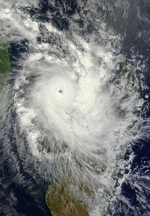
Madagascar’s week did not start off on a high note, as a strong cyclone dubbed “Cyclone Hellen” took aim at the country. Hellen took a turn towards Madagascar on Sunday and quickly deepened due to ideal cyclone conditions – as much as 60mb drop in 24 hours – over the warm waters surrounding Madagascar. Considered a very powerful storm for the country, this category four cyclone brought winds of 230km/h, while located in the northern part of the Mozambique Channel to the northwest of Madagascar.

Image of Hellen on Sunday, after it underwent rapid intensification, still over the northern Mozambique Channel. A well-defined eye can be seen. (Source: NASA: MODIS/LANCE)

Fortunately, the saving grace that helped avoid widespread damage to the country was that the eye of the storm was very compact and it collapsed easily after moving off of the warm ocean waters. The surface pressure of the cyclone went back up 65mb in the following 24 hours. Because of this, sustained winds significantly weakened to around 80km/h after making landfall therefore only a few coastal areas received damage to structures. Mahajanga, a large city with a population of over 100,000 and located close to where the cyclone made landfall, received just over 150mm from the storm. Although landslides were of concern over Madagascar’s rugged inland terrain, residents took necessary precautions and no injuries were reported. Hellen’s remnants lingered over Madagascar before getting pushed over to the neighbouring country, Mozambique, then dying off.

Another unrelated tropical storm is currently spinning up in the western Pacific Ocean and is headed toward the Philippines. This storm however, is not benefiting from ideal conditions for typhoon intensification. It is not expected to strengthen to more than a category one and will likely be more of a rain-maker than a powerful storm. The small Pacific island of Palau should still be on the lookout though, as the storm is on track to pass directly over the island. Regardless, an eye (no pun intended) will need to be kept on this storm.

Elsewhere in Weather News: March 29th, 2014

Atlantic Storm Slams Canadian Maritimes

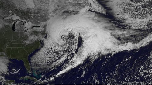
This past week a strong Nor’easter affected the Canadian Maritimes which brought large amounts of snow as well as record-breaking wind gusts. The dynamic system that started off as a weak low off Florida’s east coast and quickly deepened, over 40mb in 24 hours, over the Gulf Stream. By the time the low had traveled up the East Coast and reached the Canadian Maritimes, it had peaked in strength at 955mb. Although this system, a cold low, was much different dynamically than a hurricane, it brought extreme wind gusts of category 3 strength; 186km/h gust in Wreckhouse, NL (breaking the old record of 180km/h). Widespread 100km/h gusts were reported across both Nova Scotia and Newfoundland.

Impressive picture of the Nor'easter just before the storm reached maximum intensity. (Source: NOAA)
Impressive picture of the Nor’easter before the storm reached maximum intensity. (Source: NOAA)

The forecast proved to be a tough one, especially along Nova Scotia’s coast, where warm air coming off the Atlantic Ocean had an impact on the snow amounts. Widespread amounts of 40cm were reported in both Nova Scotia and New Brunswick. Halifax’s snowfall total, which was affected by the warm air coming off the Atlantic, only received 21cm. The highest total out of all the major Maritime cities was Charlottetown, PEI, which reported an incredible 53cm from the storm and experienced snowfall rates as high as 10cm per hour. Unsurprisingly, about 20,000 people were out of power at some point in the Maritimes and most flights in Halifax were cancelled on Wednesday. The Confederation Bridge connecting PEI to the mainland was also closed, due to the strong winds.

Only to add salt to the wound, the Maritimes are expecting another messy weather system to affect the region Sunday night into Monday. It will bring a mixed bag of precipitation to the region, depending on proximity to the Atlantic Coast; rain and freezing rain can be expected near the coast such as in Halifax. Further inland into New Brunswick, ice pellets/freezing rain transitioning to heavy snow will fall. The precipitation amounts will not be as high as the previous system, but nonetheless significant, as models are snowing that conservatively 15cm could fall in the snowfall region and 20mm of rain near the coast.

Elsewhere in Weather News: March 22nd, 2014

Below Normal February Temperatures for most of Continental US; Will Return

What seems to be the winter that won’t give up in Southern Manitoba has not only been persistent in the Canadian Prairies, but also a good chunk of the United States. The central and eastern half of the US has been fairly consistent in staying below normal in February thanks to a persistent trough on the east coast and ridge over the west coast. Consequently, a northwest flow in the upper levels of the atmosphere has established itself over the Northern US Plains and Midwest and, as a result, Arctic highs were continuously helped down into the region. Interestingly enough, central North America has been one of the only regions in the world to experience below normal temperatures in February.

Temperature anomalies across the globe for February, notice the below average in Central/Eastern US, contrasted by the much above normal just to the east, over the ocean. This is caused by persistent troughing on the East Coast. (Source: NOAA)

The pattern, which has not shifted around much this winter, has caused extremes to occur not only temperature-wise but also precipitation wise. The problem is that with the ridge staying put over the area systems have trouble making their way into the region and instead diverted further north. California continues to experience severe to exceptional drought – the highest level of drought, as per the US Drought Monitor. Consequences might not be immediate but could spell trouble once the wildfire season rolls around, and when water reserves literally start to run dry in the state. Currently, about 60% of the state is considered to have an above average risk for wildfires due to the drought, according to NICC.

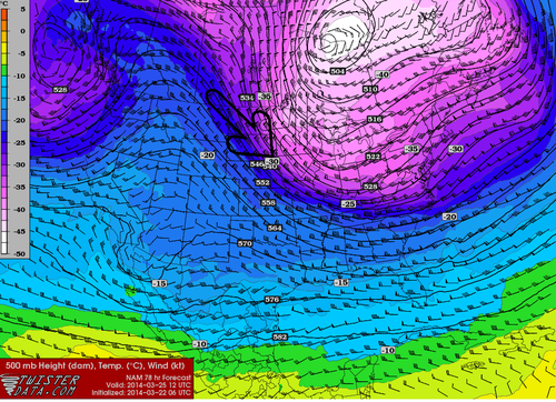
Sunday night into early next week yet another blast of Arctic air is expected to infiltrate across a good chunk of the United States. In addition to this cold blast, models are showing a potent Nor’easter Tuesday-Wednesday next week blasting through the Northeast US and Atlantic Canada which could drop significant amounts of snow. However, there is a glimmer of hope for the central United States as most models are in agreement that temperatures late next week into next weekend will be either bounce back to normal or slightly above normal.

500mb northwest flow returns to the region this week, shown by the NAM here, on Tuesday morning. (Source: Twisterdata)
Northwest flow returns to the region this week, shown by the NAM here, on Tuesday morning. (Source: Twisterdata)