Elsewhere in Weather News: March 15th, 2014

Cyclone Lusi Heads towards New Zealand; Otherwise a Calm Week

The weather this week has been fairly uneventful but the most significant event has been the three tropical storms that churned simultaneously off Australia’s north and east coast earlier this week. The strongest of the three storms, Cyclone Lusi, was of category three at its strongest point when it moved over the Island of Vanuatu. Vanuatu is an Island on the eastern side of the Coral Sea, near New Caledonia. Flooding was the biggest of the resident’s worries as the cyclone was fairly slow moving; affecting the island from Monday through Wednesday. Of course, strong winds were also problematic as many houses on the island are not built to withstand category three cyclone winds (120km/h). Long-term damage could also be concerning – crops destroyed and freshwater contaminated by flooding waters. Nearly 40,000 people living on the island were affected and about 100 people were evacuated from low-lying areas. Unfortunately, six people perished from trees falling on houses and fast currents associated with the floodwaters.
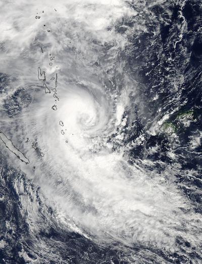
Cyclone Lusi as seen by NASA's Aqua satellite on March 12th, after the cyclone had passed over the northern islands of Vanuatu. (Source: NASA)
Cyclone Lusi as seen by NASA’s Aqua satellite on March 12th, after the cyclone had passed over the northern islands of Vanuatu. (Source: NASA)

The cyclone continued its trek southwards towards New Zealand where it is expected to make landfall this morning. As it moved south the cyclone encountered colder waters causing it to weaken significantly and start its transition to an extra-tropical storm. On Friday evening the cyclone still packed somewhat of a punch as it affected the northern island of New Zealand; about 7,200 people were reported to not have power and residents were urged to stay inside. New Zealand averages about one tropical storm per year.

Elsewhere in weather news, weather has remained relatively quiet across the globe, apart for severe thunderstorms affecting Argentina and Australia.
Elsewhere in Weather News: March 8th, 2014

Cyclone Takes Aim at Northern Queensland

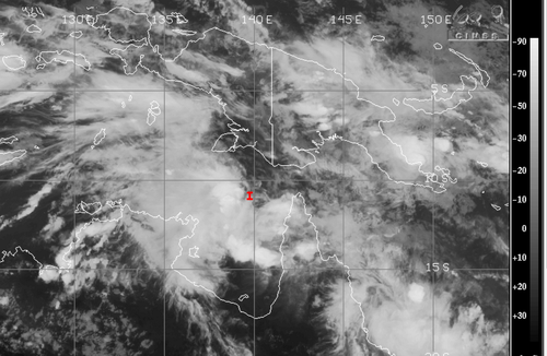
On Thursday, March 7th an area of convection appeared off the northern coast of Australia in the Arafura Sea, associated with a weak tropical disturbance. Since then the convection has remained nearly stationary due to steering winds being fairly weak but not much organization has occurred. However, the disturbed area is expected to organize quickly today into tomorrow as it drifts slightly to the southeast where shear values are low and sea surface temperatures are very warm; 30-31°C. By Sunday evening it is expected that Gillian become a category two cyclone, just off the northern coast of Queensland.

Infrared satellite image of Gillian looking rather disorganized, but with some deep convection on Friday evening. (Source: CIMSS)

The Australian Bureau of Meteorology (BoM) warns that winds could approach 150km/h in areas closest to where it makes landfall. Shoreline areas are most at risk along the peninsula due to the storm surge and large waves. Flooding/flash flooding is also expected as areas along the coast have received around 850mm in February; over double their average rainfall for that month. Another 250-400mm could fall in the region due to Gillian. It is expected that Gillian linger through the beginning of next week and die out as it continues south over land.

Queensland's rainfall for the past 30 days, note the area of 800+mm, this is where Gillian is headed. (Source:BoM)
Queensland’s rainfall for the past 30 days, note the area of 800+mm, this is where Gillian is headed. (Source:BoM)

Interestingly enough a second, weaker, cyclone is spinning off the east coast of Queensland and is expected to make landfall at about the same time that Gillian does as a strong category one. Both cyclones are to watch Sunday into the beginning of next week as they pose a threat to the northern and eastern areas of Queensland. The Australian cyclone season begins November 1st and ends April 30th and on average they see about ten cyclones per year.

Elsewhere in Weather News: March 1st, 2014

Australian Town Sees Flooding Rains

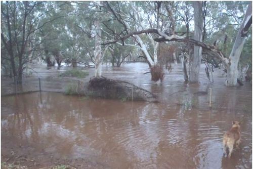
The town of Dajarra, a small Australian town in the northwestern part of Queensland, has faced flooding problems that started mid-week and worsened Thursday. The flooding was associated with a surface trough of low pressure that stayed nearly stationary for over 24 hours and sparked slow moving convection. General reports of 60-80mm in the region were reported but some localized amounts reached as high as 150mm. In addition, the region has been drought-stricken in the past few months which makes it tougher for water to infiltrate soils and easier to runoff.

Wills River overflows its banks in Dajarra. (Source: ABC)

The result of all this rain was that creeks overflowed their banks and quickly turned into raging rivers. Most residents were evacuated as homes were threatened or were inundated by the floodwaters. Some workers from the railway were also stranded but have since been saved from the waters. The town is still cut off due to floodwaters as of Friday evening.

Dajarra’s average rainfall for the whole month of February is 100mm but they have received over 125% of this in the past week. It appears as though the surface trough will linger until the end of this weekend and continue to bring unsettled weather. This event comes two weeks after the flooding that occurred in Adelaide, South Australia, which wreaked havoc on the city. In one day 73mm of rain was dumped on Adelaide making it the most rain the city had received on a single day in February since 1969.

Elsewhere in Weather News: February 15th, 2014

US East Coast Experiences another Blast of Winter

Yet another winter storm has affected the US Southeast and eastern seaboard this past week. The low pressure quickly organized just offshore over the warm waters of the Gulf Stream, but at the same time dragging down brisk Arctic air all the way down to the southern states such as Georgia and Alabama. As the low pressure system moved north, just off the coast it quickly became a “meteorological bomb”. A meteorological is defined by a low pressure deepening 24mb in 24 hours, which means deep intensification is occurring. It’s not uncommon to see this occur off the coast in winter because of the large contrast between ocean and land temperature, but is uncommon to see this happen in the middle of the continent.

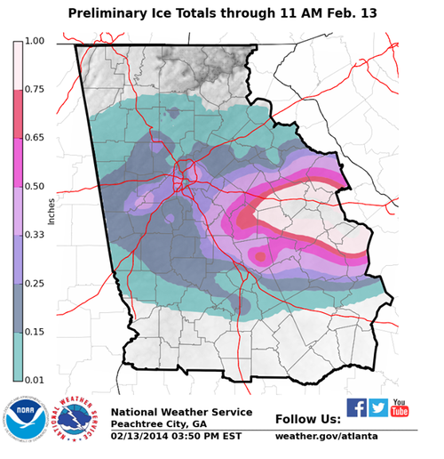
Due to this storm, over 6,000 flights had been cancelled across the eastern seaboard and services totally shut down in the south for 36 hours because of the storm. It appears that the worst damage occurred from Augusta Georgia, westwards, to just south of Atlanta. Here ice accumulation totals approached 2.5cm which made trees and power lines top heavy and eventually collapsing. Snow amounts in the northeast US were also impressive, where snow rates of 10cm/h fell in the heaviest bands. The highest reports were 70cm in South Berne, NY and 61cm in Shrewsbury, VT. Thundersnow was also reported just west of New York City as multi-cell thunderstorm clusters drifted north of the warm front and transitioned to snow producers.

Ice accumulation with the latest winter storm affecting Georgia. (Source: NWS Atlanta)

Residents should not put their shovels away quite yet though as a strong low off the coast is expected in the Wednesday-Thursday timeframe next week which will be another big weather producer for the East Coast.