Elsewhere in Weather News: August 3rd, 2013

Damaging Tornado Touches Down in Italy

On Tuesday, the 30th of July a strong tornado touched down in the northern part of Italy in the city of Milan. The storm which was associated with the same upper level low as talked about in last week’s EIWN, as well as a very potent shortwave nearby, was fed by very moist air coming straight from the Mediterranean Sea. The conditions were favorable for tornadoes with low cloud bases and a favorable shear profile.

The tornado, rated an EF-2 (winds of 178-217km/h) on the Enhanced Fujita scale, touched down in the industrial part of Milan, called Grezzago. It quickly picked up lots of debris; easily ripped off roofs, snapped trees and even picked up vehicles. One lucky resident caught in the tornado remembers her car being lifted into the air and thrown about 10 meters, she was uninjured. Thankfully, no fatalities came from this tornado, though 15 people were found to have injuries caused by the twister. There easily could have been more injuries, such as the person who was filming this video, had the windows not held up.

Very dangerous video of an office worker watching the tornado from close up. Notice all the debris. (Source: AP)

This is not the first serious tornado Italy has seen this year, back in the beginning of May, a strong EF-3 tornado touched down in the central part of Italy, caused quite a bit of damage as well as injured 20 people. Italy will get a break this weekend as no severe weather outbreaks are expected.
Elsewhere in Weather News: July 27th, 2013

France Faces Severe Storms; More Coming Today

France has had its fair share of severe storms this past week, with more of it expected to come today (Saturday). A level 3 “severe” thunderstorm, the highest risk possible, has been issued by ESTOFEX (European Storm Forecast Experiment) for the northern half of France. Conditions are favorable for tornadoes with a warm front draped across the region and incoming cold front from the west; an upper-level low spinning off the coast of France over the Atlantic will provide sufficient destabilization in the upper levels of the atmosphere.

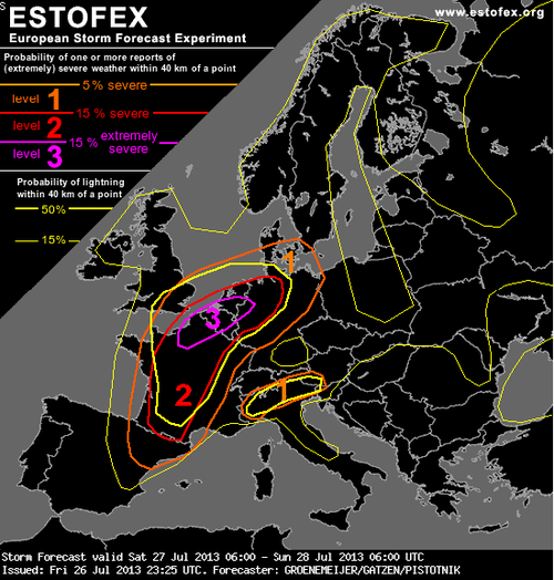
ESTOFEX forecast

ESTOFEX forecast for today, risk 3 in northern France, Belgium, Netherlands and northwest Germany. Highest risk for large tornadoes resides here. (Source: ESTOFEX)

The only potential flaw in the setup could be due to the large MCS that fired up on Friday evening in west-central France as it continues to move northeast potentially leaving debris cloud in the region this morning. But with that said, as of Friday evening, the MCS was moving fairly quickly, and at this rate would be out of the region in time for tomorrow’s setup. With dewpoints in the low twenty Celsius range, shear plentiful with the approaching upper-level trough, and a great shear profile, all kinds of severe weather could be in play, including powerful tornadoes. The severe weather risk also extends into northwest Germany, Belgium and the Netherlands.

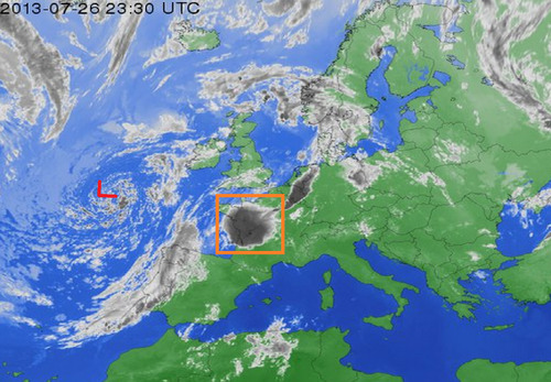
MCS and upper level low

Upper level low spinning off the coast of France and MCS in orange box that could hinder storm activity tomorrow. Infrared satellite image taken Friday evening. (Infrared satellite image source: Weather Online)

The expected severe weather follows a significant weather outbreak that occurred in France on Tuesday afternoon. Strong storms passed through the Burgundy region dropping large hail (between ping-pong and golf ball size) and causing significant damage to vineyards. In this region, crop losses are as much as 75% in the hardest hit areas. Flooding was also an issue, where some main roads such as the one between Pommard and Volnay were flooded out and impassable.

In 2008 an EF-4 tornado touched down around Hautmont, France and caused 4 fatalities and 18 injuries. Severe weather is not that common of an occurrence in France, with only a couple outbreaks per year.

Elsewhere in Weather News: July 20th, 2013

Severe Weather Outbreak in Southern Ontario; Numerous Warnings Issued Friday

On Friday, severe weather rolled across much of southern Ontario, southern Quebec and nearby states such as Michigan and New York. Severe weather was imminent in the region as a strong squall line of storms formed with some bowing segments in the morning and continued into a great thunderstorm environment as the afternoon wore on. CAPE values were quite high, shear sufficient and for any storms that remained discrete, a decent tornado potential was there before getting absorbed into the squall line. This prompted a plethora of warnings to be issued, including numerous tornado warnings throughout the day.

Wind damage was the biggest concern on Friday though, numerous reports of wind gusts exceeding 100km/h and even one report as high as 119km/h in Waterloo Ont., were reported. In turn, significant damage was reported across southern Ontario; mature trees knocked down, trees falling on homes and winds flattening crops. As of Friday night 550,000 people were still without power in Quebec and Ontario due to winds knocking down power lines and trees falling on lines. Storm survey teams are expected to head out to various spots across southern Ontario tomorrow to determine if damage was caused by straight-line winds or a tornado touching down. Two unconfirmed funnel clouds had been reported around the towns of Bradford and Barrie, Ontario. Unfortunately one person has died and ten more have been injured because of falling tree limbs; this is a reminder to people that even though a tornado might not be imminent, it’s better to take cover as a storm approaches.

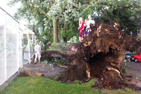
Downed tree

Large trees downed in Toronto by strong winds produced in Friday’s storms. (Source: City News)

The cold front behind this system will put end to Ontario’s heatwave. Many cities in southern Ontario, including Toronto, had reached “official” heatwave status by reaching 32°C three days in a row. This combined with high humidity values made for excessive heat, therefore it’s likely that most residents will welcome the cooler and drier air on Sunday.

Elsewhere in Weather News: July 13th, 2013

Strong Typhoon Makes Landfall in Taiwan

A strong typhoon, Typhoon Soulik, has made landfall in northern Taiwan last night bringing heavy rainfall and strong winds in the order of around 160km/h – considered category two. Soulik, once a category four typhoon, encountered cooler waters before making landfall and Taiwan’s rugged terrain continues to tear it apart. It’s expected to cross the South China Sea and make a second landfall on China’s southeast coast as a tropical storm. Most models show it heading into China’s mainland weakening into a tropical depression and further on, a low pressure system. Although only a tropical depression, Soulik will bring copious amounts of rain into the mainland, prompting fears of possible flooding later this weekend.

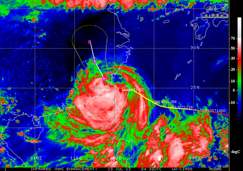
Soulik

IR image of Soulik on Friday night. Expected track and intensity overlayed. (Source: CIMSS)

As of Friday night, electricity disruptions, 1 death and two dozen injuries had been reported. Around 8,500 people had been evacuated prior to Soulik making landfall because they lived in landslide-prone terrain.