Elsewhere in Weather News: June 15th, 2013

Colorado’s Black Forest Fire

Residents of Colorado Springs and surrounding areas have been on high alert this past week because of wildfires in the area that are burning out of control. Currently, there are three large fires burning in Colorado. The largest wildfire of the trio is known as the Black Forest Fire. This fire covers about 60 square kilometers and has destroyed about 400 homes already, as of Friday evening. Unfortunately, two people have also perished from this fire. On Friday thunderstorms moved over the area but although they brought much needed rain, they also had undesired effects such as cloud to ground lightning strikes that potentially sparked up new fires. The Black Forest Fire is around 30 percent contained as of Friday evening so firefighters still have quite a bit of work to do this weekend.

The reason for such extreme wildfire events this spring in Colorado can be associated with drought. The severe drought that was seen throughout the US Plains last year and into this spring has shifted slightly further west. Although areas of the Plains have been mostly relieved of drought from thunderstorm activity this spring, Colorado has continued to experience severe to exceptional drought. The town of Colorado Springs is located under extreme drought which translates into little moisture available for vegetation and in consequence, wildfires are easily sparked.

Black Forest Fire

Plume of smoke from the Black Forest Fire threatens homes in the foreground. (Source:Reuters)

Temperatures are expected to remain quite warm with highs in the upper twenties and even low thirties in the area this weekend, not helping the fire risk. There is also a chance of storms. The longer range doesn’t look promising for drenching rains either as a ridge is expected to redevelop in the southern US Plains mid next week.
Elsewhere in Weather News: June 8th, 2013

Severe Flooding in Europe

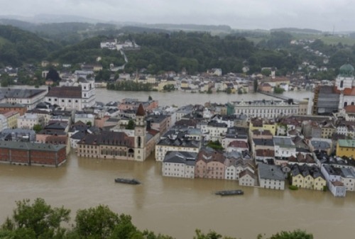
Major flooding has swept across central parts of Europe where Slovakia, Germany and the Czech Republic have all experienced crippling flooding this past week due to extreme rainfall. Amounts of 75mm were widespread across that part of the continent, and near the Alps, significantly higher amounts of precipitation were observed (some as snowfall at higher elevations). A few reports of 150-200cm of snow were recorded in Austria and Germany at high elevations.

Flooding

Severe flooding in Passau, Germany where the Danube easily overflowed its banks. (Source: AFP)

Rivers such as the Danube and Elbe have reached levels last attained 11 years ago and are threatening or have already breached sandbag dikes in some areas. Over 300,000 sandbags and counting have been prepared and put in place to prevent both rivers from overflowing their banks. The threat of a flood has forced residents out of their homes – as many as 40,000 people have been forced to move away from the nearby dikes and up to higher ground. The flooding upstream also has residents in Hungary, especially Budapest, worried as the Danube River has not crested yet but is expected to reach its peak later this weekend. Dikes there are expected to hold if the current crest projection is correct; it is believed the crest will be about a foot below maximum capacity.

Unfortunately 17 people have already lost their lives to the rapidly rising floodwaters and damage estimates top the 15 billion mark. Crop damage is widespread across Germany where over 250,000 hectares have been flooded out.

The forecast for central Europe calls for some rain on Sunday, associated with a trough but these showers will be nothing near as significant as what was experienced last week.

Elsewhere in Weather News: June 1st, 2013

This past week featured a number of severe weather events across the Great Plains of the United States. At least 98 tornadoes had been reported since Monday as of Friday evening.

image

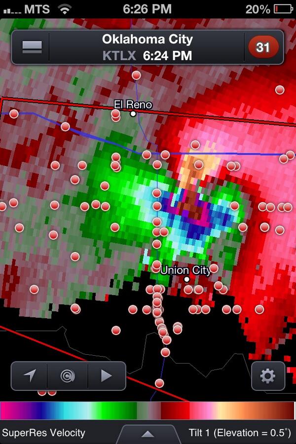
Extreme Rotation was Observed as a Supercell Thunderstorm Approached Oklahoma City on Friday

This series of days with severe thunderstorms and tornadoes was caused by similar atmospheric conditions to what was in place around the time of the Moore, OK tornado. These conditions revolve around four properties that forecasters look for when assessing the potential for thunderstorms, the properties being moisture, instability, shear, and a triggering mechanism. Over the past week copious amount of moisture were present over the US Plains, noted by very humid conditions at the surface. These hot and muggy conditions caused the lower atmosphere to become very unstable generating very high levels of instability. A large dip in the jet stream, called a longwave trough, came onshore from the Pacific Ocean earlier this week putting the plains under a strong jet stream causing wind shear. And finally a series of fronts and drylines offered triggering mechanisms for storms throughout the week. These four ingredients came together perfectly to generate many severe and indeed tornadic storms all over the United States.

The week was capped (no pun intended) off on Friday by a complex of supercell thunderstorms that passed through Oklahoma City causing widespread damage and at least 5 deaths. The rotation in these thunderstorms (seen as the bright colour in the image above) has been referred to by many meteorologists as the strongest they have ever seen. In addition to several tornados touching down in the Oklahoma City Metro area, hail as large as softballs pelted down in some areas while nearly the entire OKC metro area received between 6 – 10” of rain causing widespread flooding with water as deep as 4’ in some places. Flash flood warnings continue this morning for much of eastern Oklahoma state with widespread overland flooding ongoing.

Elsewhere in Weather News: May 25th, 2013

Powerful Tornado Devastates Moore, Oklahoma

As you may have heard through media reports these past few days, Oklahoma was subject to severe tornadic weather this week which resulted in catastrophic and tragic consequences for many. Supercells posed a threat to residents as they dropped a number of large tornadoes – including a historical tornado that struck Moore on Monday, May 20th. A longwave trough (same as talked about in last week’s EIWN) was in place on the west coast as were other factors that made the conditions ripe for strong, long tracked tornadoes.

Moore tornado

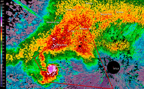
Supercell with hook echo and large debris ball (just west of Moore), May 20th, 2013. (Source: UCSB)

Moore, with a population of over 50,000, is located in the heart of Tornado Alley and has been struck directly by tornadoes 3 times in the past 15 years. The fact that they are situated where moist air comes in from the Gulf of Mexico and where a source of dry air from the south-west US not too far away, causes many dryline setups in mid-late spring – ideal conditions for triggering storms.

On May 20th, storm cells fired up early in the afternoon and quickly became supercellular and well organized with rotation. As the supercell approached the Moore area, a hook echo formed and not long after, a debris ball could be seen on radar just before it was passed over Moore – it was obvious that Moore was in dire trouble and a tornado had touched down. Thankfully, the National Weather Service in Norman provided generous lead time of 16 minutes before the tornado entered Moore, certainly saving many lives.

Moore damage

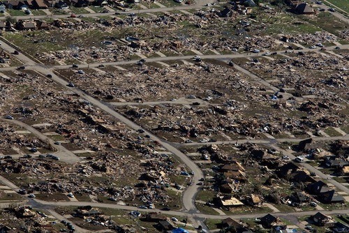
Aerial view of the damage in Moore. (Source: AOL)

Tragically however, even though advance warnings were given, 24 people perished that day. In some areas it was not possible to take refuge in interior rooms; EF-5 winds easily ripped apart any building in the tornado’s path. Damages are estimated to be in the billions of dollars with an estimated 1,300 homes destroyed and countless number of vehicles wrecked.

Incredible video of a close up view of the 2013 Moore tornado, not to be tried at home – very dangerous! (Source: Jeffery Lechus/Youtube)

It appears the storm track will remain active with troughing across the western part of the continent and intermittent shortwaves rounding down the ridge across Southern US. Severe weather looks likely in the High Plains region of the US (Nebraska, Kansas) in the coming week – not out of the ordinary for these locations at this time of the year.