Elsewhere in Weather News: May 18th, 2013

Severe Weather Event South of the Border: Possible AWM Chase Sat/Sun
Trough

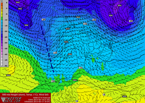
Negatively-tilted trough on Saturday late afternoon. (NAM) (Map source: Twisterdata)

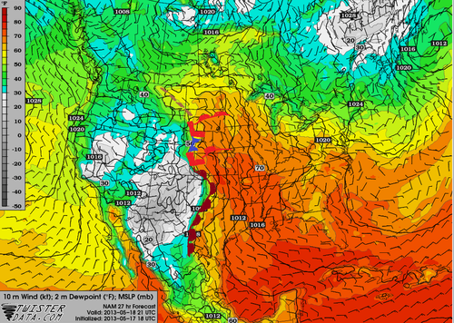
The same system that will cause Southern Manitoba to have a rainy May long weekend is expected to produce a string of severe weather days across the Central US, starting today, continuing through at least Tuesday. A negatively-tilted longwave trough approaching from the west will help to provide the necessary wind shear, lift, and instability for severe storms to develop. A broad surface low with an extending cold front from Central South Dakota through Nebraska will be in place with a warm front slicing through north-east South Dakota. Another, stronger, low pressure center will be in place in Kansas with an extending dryline all the way down to Texas. These features will offer enough lift for severe storms on Saturday. This, combined with other severe weather ingredients such as a stiff low level jet (LLJ), high amounts of instability, deep low level moisture and low cloud bases is ideal for severe weather and tornadoes. The Storm Prediction Center has issued a Moderate Risk for Nebraska and Kansas with a Slight Risk extending up to North Dakota for their 2 Day Outlook as of Friday night.
Surface Analysis

Surface analysis of the Plains. (Map source: Twisterdata)

As of Friday evening these ingredients appeared to be maximized in the vicinity of north-western Kansas near the Nebraska border. Storms will not be confined to this area though, as strong to severe storms will still be possible into South Dakota and down into Oklahoma, but whether they will be tornadic or not is still to be seen.

The ingredients that will be in place tomorrow in South Dakota:

  • Instability: about 2000J/Kg of MLCAPE (mixed layer)
  • Surface dewpoint: 18°C
  • Shear: 40 knots (0-6km shear)
  • LLJ: 20 knots
  • Lifting condensation levels (cloud bases): around 750m

With the LLJ being only 20 knots, an AWM Chase is still up in the air. If models tend towards a stronger LLJ, the chase will likely be on with a target somewhere in Central South Dakota.

Sunday also offers a significant severe weather threat as the trough continues its trek towards the east. Severe weather risk would extend into Southern Minnesota all the way down to Oklahoma. There is still some uncertainty about Sunday but it does look like another significant severe weather outbreak day for the Plains and Upper Mississippi Valley. Stay tuned in the comments section as the event approaches, updates will be posted.

AWM Chase is On!

Two of the AWM team members will be out chasing this setup along with a student from the University of Manitoba. You can keep up with their chase right here:

new TWTR.Widget({
version: 2,
type: ‘list’,
rpp: 30,
interval: 30000,
title: ‘May 18, 2013’,
subject: ‘AWM North Daktoa Chase’,
width: ‘auto’,
height: 500,
theme: {
shell: {
background: ‘#3c3c3c’,
color: ‘#eeeeee’
},
tweets: {
background: ‘#eeeeee’,
color: ‘#2c2c2c’,
links: ‘#489ce1’
}
},
features: {
scrollbar: true,
loop: false,
live: true,
behavior: ‘all’
}
}).render().setList(‘WeatherInThePeg’, ‘awm-team’).start();
Elsewhere in Weather News: May 11th, 2013

Cyclone Duo in Indian Ocean

Two separate cyclones formed in the Indian Ocean this week and will continue to intensify and organize over the weekend. A low shear environment combined with warm sea surface temperatures of around 30°C, were key factors in the formation of these two cyclones.
The first cyclone, located south of the equator, is named Jamala. This cyclone is headed west and is only expected to intensify to a category one hurricane for a short amount of time before weakening to a tropical storm again. Despite reaching category one and heading west towards land, Jamala is not expected to affect Madagascar or any parts of eastern Africa as models show it weakening to almost nothing before reaching the coast.

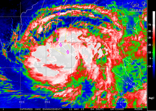
The second cyclone, cyclone 01B located north of the equator, is more of a concern to Bangladesh and surrounding countries. This cyclone has the potential to cause substantial damage to Bangladesh as land is prone to flooding there. Storm surge will likely be an issue, depending on the strength of the hurricane when it makes landfall. As of Friday evening, 01B had estimated maximum surface winds near the 95km/h mark but was expected to increase in strength as it moved north, towards Bangladesh. Landfall is still a ways away, but its stronger outer bands are expected to arrive near the Myanmar and Bangladesh shores early Tuesday.

Cyclone 01B

Enhanced infrared image of tropical cyclone 01B Friday night. (Source: CIMSS/NHC)

The Indian Ocean cyclone season is most active from the beginning of spring to early winter but it is possible to have cyclones form throughout the year.

Elsewhere in Weather News: May 4th, 2013

Let it Snow!

Record-setting snowstorms were the topic of conversation in parts of the US this week.

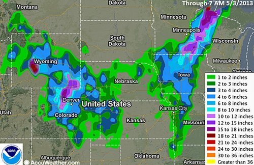
Snowfall reports

Snowfall map until Thursday morning. (Source: NOAA)

Springtime weather was delayed once again as a significant trough moved across Central US dragging down unseasonably cold arctic air with it. Friday morning, temperatures at 850mb reached below freezing all the way down to Mexico; and snow fell from Northern Ontario all the way down to northern parts of Arkansas and Oklahoma! Many snowfall records were shattered, some of the most significant being:

  • Britt, Iowa – Achieved a snow depth of 28cm, beating the old record of 25cm (in 1947).
  • Chippewa-Falls/Eau Claire, Wisconsin – Recorded a snowfall of 22cm shattering the old record of 5cm (in 1946).
  • Extreme north-west Wisconsin – Recorded a snowfall of 46cm.

The trough will not make it to the East Coast as the main jet stream is retreating north and a cutoff low will form in southern US. This cutoff low is expected to slowly drift across the region feeding into tropical moisture while dropping significant rainfall over parts of the south-east and east-central US. Accumulations of over 80mm are expected, increasing concerns that flash floods might be a problem over the weekend.

In other news, a category one cyclone formed off the north-eastern coast of Australia, however it had minimal impacts on land as it fizzled out and only brought lowland flooding and erosion to coastal areas.

Italy also saw an active week with a large tornado reported in it’s northern region. An approaching shortwave combined with significant instability and sufficient shear on Friday was the cause for severe storms in the area.

Short video of the Italian tornado as seen from the nearby city of Castelfranco Emilia. (Source: R. Melotti)

Elsewhere in Weather News: April 27th, 2013

Fairly Calm Week

It has been relatively quiet weather-wise across the globe this week with no significant events affecting heavily populated areas. However, there were still some extreme weather events that took place, although more localized.

This past Thursday, a cold front pushing south across Hong Kong and parts of south-east China dropped excessive amounts of rainfall, triggering flood concerns. The front had significant warm and moist air to work with as it slowly moved south towards the South China Sea. Several reports came in from south-eastern China showing 50mm of rain in a 24 hour period, concerning residents of increased flood risk this weekend and into next week thanks to another low pressure through making its way into the region.

In other news, isolated severe storms pushed through the state of Louisiana Wednesday. The long cold front extended from Southern Ontario all the way down to Louisiana; where dynamics were most favorable for severe storms midday Wednesday. A weak tornado even touched down in Keeling, a suburb of New Orleans, causing power outages and downing trees. After the storms moved through, 32,000 people in the area were left without power, but it has since been restored. There is a chance for more severe weather in the same area on Sunday and severe weather in the Plains region early next week. Following those events, there isn’t any indication of severe weather until at least next weekend as moisture gets flushed out. What comes after that remains to be seen as there is much uncertainty between weather models.

Dewpoints

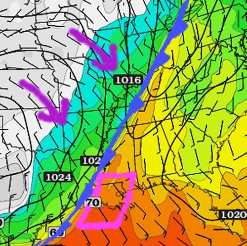
Surface dewpoints (in Fahrenheit) Wednesday morning. Cold front is clearly visible and the circled area ahead of the front in Louisiana had the highest tornado potential. (Source: Twisterdata)