Elsewhere in Weather News: October 20th, 2012

Severe Weather Outbreak in Dixie Alley

This past Wednesday evening a severe weather outbreak comprised of severe winds and strong tornadoes occurred in the southern United States, causing damage to rural areas of Northern Mississippi. This was brought on by the same system we experienced over the past couple of days. The polar jet stream along with a strong low level jet overhead and plenty of moisture from the Gulf of Mexico combined to create conditions ripe for tornadoes in Dixie Alley.
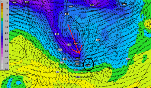
Trough

500mb heights/temperatures with trough (arrow) and circled area where the tornado outbreak occurred. (Source: Twisterdata)

The strongest, a half-mile tornado, rated EF-3 by the National Weather Service, touched down near Jackson Mississippi and caused quite a bit of damage, tearing up large trees and wrecking mobile houses. As the tornado trekked for 26 kilometers, nine people taking cover inside mobile houses were injured but thankfully no fatalities occurred during this event. As the night wore on, more tornadoes touched down in Mississippi and Arkansas, doing damage to rural homes and cutting off power to residents.

Tornado damage

Tornado damage in Leake County, MS. (Source: WLBT)

A few colder days will follow the trough this weekend and a return flow will set up, bringing warm and humid weather back to the region. Weather models are showing another large trough will likely develop late next week, bringing the potential for more dynamic weather. Of course, it is not uncommon to have severe weather in the southern US during the spring and fall, when the polar jet is in the vicinity.

Elsewhere in the world the weather has remained relatively calm, except for this unusual tornado in France.

Video of the tornado in Marseille, France. (Taner Ozdil)

Tornadoes in France are not rare but are not a common sight in October.

Elsewhere in Weather News: October 12th, 2012

Tropical Storm Hits Bangladesh

A surprisingly strong tropical storm impacted southern Bangladesh on Wednesday and Thursday of this week. According to the India Meteorological Department the storm was a depression, which would give it maximum sustained wind speeds of 52km/h. Forecasters did not believe it would have a significant impact when it hit land, but in its aftermath there have been at least 26 deaths with many people still missing.

Tropical Storm damage in Bhola

Some of the destruction in Bhola is seen on Thursday. The death toll is expected to rise further (AFP/File, Str)

Strong winds from the tropical storm damaged houses and uprooted trees in coastal portions of Bangladesh. Crops were also severely damaged in the storm and some fisherman are feared lost at sea. Many fisherman suggested that poor forecasting downplayed the storm, which didn’t make it clear that they should stay on land.

Bangladesh is a relatively small, but densely populated country (estimated population is greater than 160,000,000) that is located in the delta of the Ganges river. The country’s low-lying coastal location makes it particularly vulnerable to natural disasters, including floods, tropical cyclones, and severe thunderstorms.

Sources:
http://www.ndtv.com/article/world/bangladesh-storm-toll-rises-to-26-scores-missing-278938
http://www.cnn.com/2012/10/11/world/asia/bangladesh-tropical-storm/index.html

Elsewhere in Weather News: October 6th, 2012

Record Early Snowstorm Hits Northern States

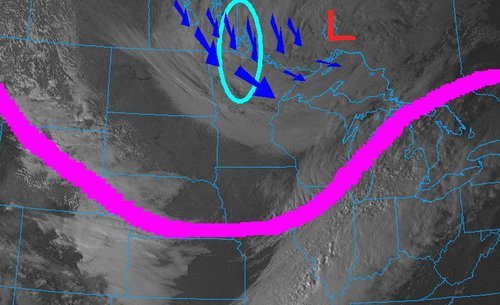
The same powerful low pressure system that brought the first significant snowfall of the season to Southern Manitoba dropped copious amounts of snow south of the border. A surface low pressure system that was moving in a north-easterly fashion combined with a deepening upper low through the area resulted in a record-breaking early winter storm this past week in North Dakota and Minnesota.

Visible satellite

Image of visible satellite taken on Friday afternoon. Large upper low is located in NW Ontario with jet stream in pink and cyan circled area the hardest hit areas. (Image source: COD)

Impressive snowfall totals were recorded in Northern Minnesota and North Dakota in the wake of the storm. Numerous cars were spotted in the ditches and tractor-trailers jackknifed in Northern Minnesota on Friday, due to treacherous road conditions. Around 3,000 people were out of power in the two states on Friday afternoon in the hardest hit areas. Woodridge, MB to Thief River Falls, MN received the heaviest bands of snow. Below lists some of the impressive amounts of snow accumulation recorded in Minnesota and North Dakota, as per reported by the National Weather Service:

  • Badger, MN (30 minutes south of Piney, MB): 30-36cm
  • Roseau, MN: 18cm
  • Grand Forks, ND: 9cm – A record for largest amount of snow to fall this early in the year (old record: 5cm)
  • International Falls, MN: 4cm – Also a record for the largest amount of snow to fall this early in the year (old record: 1.5cm)

(The remainder of the reports as of 3pm, Friday afternoon can be seen at http://www.crh.noaa.gov/news/display_cmsstory.php?wfo=fgf&storyid=87914&source=0)

This snowfall brings to a close (for now) the extreme fire danger in North Dakota and Minnesota whose conditions were similar to Southern Manitoba – extremely dry and windy. The Karlstad fire in Minnesota on October 3rd was fanned by severe 65km/h winds and drought conditions. In total, 31 buildings were destroyed; thankfully, no one was hurt.

Damage

Picture of the damage in Karlstad. (Source: MPL/Nathaniel Minor)

As the low pressure system continues to move further north-east, areas in Northern Ontario such as Timmins and Geraldton will experience their first snowfall of the year.

Elsewhere in Weather News: September 29, 2012

Typhoon Jelawat Forecast to Weaken Before Impacting Japan

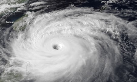
Typhoon Jelawat remains at very strong intensity despite weakening from its previous status as a super typhoon. Earlier this week Jelawat had maximum sustained winds of 220km/h near its centre, which would classify it as a category four hurricane by north american standards. The storm currently has maximum sustained winds of 145km/h (as of Friday afternoon), the equivalent of a category two hurricane.

Satellite image of Jelawat on Thursday morning when it was heading toward Taiwan with 155mph sustained winds

Satellite image of Jelawat on Thursday morning when it was heading toward Taiwan with 155mph sustained winds. (JMA/NOAA) – via Washington Post (see sources)

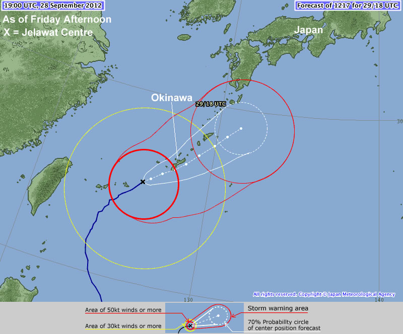
Jelawat is presently located near Okinawa and is moving in a north-easterly direction toward Japan, weakening the further north it moves. According to the Japanese Meterological Agency Jelawat will impact the Ryukyu Islands, including Okinawa, today before moving toward the Japanese mainland late today into Sunday.

Jelawat's Forecast track by the JMA

Jelawat’s Forecast track by the JMA

Thus far Jelawat has not caused any devastating damage, owing to the fact that it has not yet impacted any large land masses. Some damage was reported on Lanyu (Orchid Island), located just off Taiwan’s south-eastern coast. No casualties have been reported on Lanyu, but the harbor, gas station, and supermarket were reportedly destroyed. There may be more damage as this typhoon moves over the more heavily populated Ryukyu Islands this weekend.

Sources: http://www.taipeitimes.com/News/front/archives/2012/09/29/2003543923, http://www.hko.gov.hk/wxinfo/currwx/tc_gis_e.htm, http://www.washingtonpost.com/blogs/capital-weather-gang/post/typhoon-jelawat-closing-in-on-okinawa-japan-nadine-becomes-hurricane-again/2012/09/28/c0f6844c-097b-11e2-a10c-fa5a255a9258_blog.html